Reach 9 · Congress to Blunn Creek
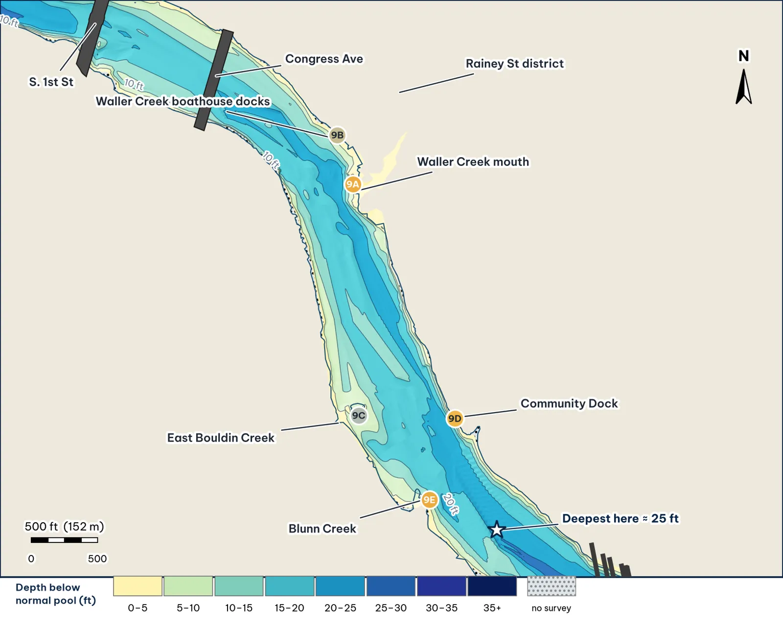
Congress Avenue to Blunn Creek, past Rainey Street and the Waller Creek mouth. Depths from my grid of TWDB 2008 points analysis.
The bottom analysis
- A broad channel, 20–24 ft deep. The deepest point of each cross-section has a median of about 22 ft; the deepest cell is about 24 ft. The reach is about 615 ft wide.
- Two creek deltas. Waller Creek (north bank) drops from about 7 ft to 19 ft within 95 ft of its mouth (9A). Blunn Creek (south bank) breaks from 8 to 15 ft within about 40 ft, with 20-ft water within 90 ft (9E).
- The steepest bank is at the Community Dock on the north shore: about 1 ft at the dock to 19.5 ft only 58 ft out (9D).
Cover and forage
- Creek mouths, reeds and docks. OpenStreetMap shows reed beds along the Congress and Rainey shorelines, rowing-club and boathouse docks (9B), and a small islet off East Bouldin Creek (9C) analysis.
- Clarity drops downstream. The City describes the water as "very clear above Lamar," and visibility falls toward downtown and I-35, first after rain (City of Austin; Torwick).
Through the seasons inference
| Season | Giant play |
|---|---|
| Winter / pre-spawn | Jig or big worm on the 9D drop and the Waller delta slope |
| Spawn | Blunn and Waller deltas: sight-fish with a soft jerkbait from a distance |
| Summer | Dock shade at 9B and 9D at first light; avoid the bat crowds at dusk |
| Fall | Glide across the Waller delta lip as shad move in |
How to fish it for a giant
The Approach
- Creek mouths first. Waller (9A) and Blunn (9E) have the deepest water closest to a creek delta in this reach. Sit in 18–20 ft and cast up onto the delta analysis.
- Docks. Skip a jig or stick worm under the 9B and 9D docks, then crawl it down the slope inference.
- Line. 20 lb fluorocarbon around docks analysis.
Access, hazards and rules
- Launch at the Holiday Inn ramp (one lane, unimproved, west of I-35) in Reach 10 and run up (TPWD access).
- Rentals at 74 Trinity St., on this reach's north bank (TPWD paddling trail).
Bats and tour boats
Bat-watching boats crowd the water just east of Congress at sunset from spring to fall (congressbats.com).
Reach 9 Spots: Congress to Blunn Creek (Rainey St, Waller Creek)
5 spots: 9A, 9B, 9C, 9D, 9E. Close-up maps from the 2008 survey; scores from the giant ranking.
9A · Waller Creek mouth into the channel
#12 of 51Deep water3Cover3Forage5Low pressure2Data5Best: Spawn · Fall
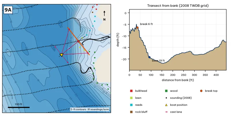
Orange line: break top. Blue dot: base of the break. Black dots: 2008 TWDB soundings. Shoreline squares: bank type (see the Bank-Type Map chapter). Contour interval: 2 ft, at 91 soundings per acre within 250 ft.
| Measure | Value |
|---|---|
| Depth at the bank | 8.0 ft (first wet grid cell, 0 ft from the OSM shoreline) analysis |
| Break top | 7.1 ft, 38 ft from the bank analysis |
| Base of the break | 19.2 ft, 95 ft from the bank analysis |
| Slope | steepest 2.7 ft per 10 ft; average 2.1 ft per 10 ft across the break analysis |
| Bank type | reeds (confidence: medium) |
| Deep-water access | 20-ft water 80 ft away; 25-ft water 2786 ft away; deepest within 300 ft: 23 ft analysis |
| Data support | good (a 2008 sounding lies within 15 ft of the break) |
Why a giant would use it. Waller Creek empties onto a reed-lined delta, and the 2008 grid drops from about 7 ft to 19 ft within 95 ft of the mouth. Creek water brings bait, and the deep channel sits a cast away, so a big fish can feed on the delta and drop back without travelling. Score factors: cover = creek delta, reeds; forage = Waller Creek inflow; pressure = rowing club, Rainey crowds. inference
Wind and current. Best wind: from the SW (blowing onto this bank) analysis. SW wind blows onto the mouth. Waller Creek runs hard after rain and muddies the delta; the clear-to-muddy edge is the target. Lake current here is slight unless Tom Miller is releasing. inference
Sun and shade today (Oct 12). This is the NE bank of the reach. With 40-ft trees, a shade band of 25 ft or more falls on the water at: 8:05 am, 9:00 am, 10:00 am. analysis
Boat position and cast lanes. Hold over about 21 ft, roughly 140 ft off the bank (yellow triangle). Fan three casts to the break top (magenta arrows), then turn and work parallel to the break along the dashed lane inference.
Big-bass plan by season (★ = this spot is a seasonal pick) inference
- Winter / pre-spawn: Jig or big Texas-rigged worm crawled down the delta slope to 19 ft. Go slow.
- ★ Spawn: Sight-fish from a distance in clear water: weightless soft jerkbait (Fluke) or stick worm to beds on the delta. The lake record (14.05 lb) took a Zoom Fluke from a creek in February.
- Summer: Walking bait or wake bait over the delta at dawn. After a storm, a big white spinnerbait along the mud line.
- ★ Fall: Glide or swimbait across the delta lip (7–19 ft) as shad move toward the creek.
9B · Waller Creek boathouse docks (north bank)
#35 of 51Deep water2Cover4Forage3Low pressure2Data4Best: Post-spawn and summer
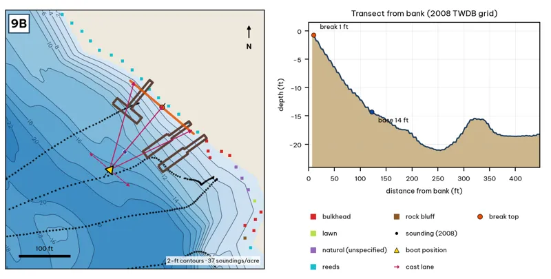
Orange line: break top. Blue dot: base of the break. Black dots: 2008 TWDB soundings. Shoreline squares: bank type (see the Bank-Type Map chapter). Contour interval: 2 ft, at 37 soundings per acre within 250 ft.
| Measure | Value |
|---|---|
| Depth at the bank | 0.8 ft (first wet grid cell, 8 ft from the OSM shoreline) analysis |
| Break top | 1.0 ft, 8 ft from the bank analysis |
| Base of the break | 14.4 ft, 125 ft from the bank analysis |
| Slope | steepest 1.4 ft per 10 ft; average 1.1 ft per 10 ft across the break analysis |
| Bank type | reeds (confidence: medium) |
| Deep-water access | 20-ft water 190 ft away; 25-ft water 2527 ft away; deepest within 300 ft: 22 ft analysis |
| Data support | fair (nearest sounding 48 ft from the break) |
Why a giant would use it. The rowing-club and boathouse docks sit on a shelf that slopes to 14 ft about 125 ft out. Dock shade over a gradual slope is classic summer big-bass cover. Score factors: cover = boathouse docks; forage = sunfish under docks; pressure = rowing traffic. inference
Wind and current. Best wind: from the SW (blowing onto this bank) analysis. SW wind blows onto the docks; the downtown skyline blocks north winds. Little current. inference
Sun and shade today (Oct 12). This is the NE bank of the reach. With 40-ft trees, a shade band of 25 ft or more falls on the water at: 8:05 am, 9:00 am, 10:00 am. analysis
Boat position and cast lanes. Hold over about 16 ft, roughly 170 ft off the bank (yellow triangle). Fan three casts to the break top (magenta arrows), then turn and work parallel to the break along the dashed lane inference.
Big-bass plan by season (★ = this spot is a seasonal pick) inference
- Winter / pre-spawn: 3/4 oz jig crawled down the slope off the dock ends.
- Spawn: Soft glide skipped or 'chopped' beside the dock posts so it hangs near the cover.
- ★ Summer: Skip a jig or a 7-in stick worm deep under the shade; the slope reaches 14 ft about 125 ft out.
- Fall: Swimbait along the outside edge of the dock line.
9C · East Bouldin mouth and the islet
#44 of 51Deep water1Cover3Forage4Low pressure3Data4Best: Spawn
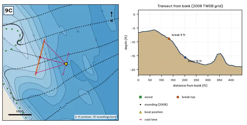
Orange line: break top. Blue dot: base of the break. Black dots: 2008 TWDB soundings. Shoreline squares: bank type (see the Bank-Type Map chapter). Contour interval: 2 ft, at 67 soundings per acre within 250 ft.
| Measure | Value |
|---|---|
| Depth at the bank | 6.6 ft (first wet grid cell, 0 ft from the OSM shoreline) analysis |
| Break top | 9.1 ft, 135 ft from the bank analysis |
| Base of the break | 15.8 ft, 205 ft from the bank analysis |
| Slope | steepest 1.3 ft per 10 ft; average 1.0 ft per 10 ft across the break analysis |
| Bank type | wood (confidence: low-medium) |
| Deep-water access | 20-ft water 480 ft away; 25-ft water 1318 ft away; deepest within 300 ft: 19 ft analysis |
| Data support | fair (nearest sounding 22 ft from the break) |
Why a giant would use it. A small islet off the East Bouldin Creek mouth, with a long shelf that breaks from about 9 ft to 16 ft roughly 135–205 ft out. Islands and creek mouths together make a natural ambush point. Score factors: cover = islet and creek mouth; forage = creek inflow; pressure = moderate. inference
Wind and current. Best wind: from the ESE (blowing onto this bank) analysis. ESE wind blows onto it. Creek inflow only after rain. inference
Sun and shade today (Oct 12). This is the SW bank of the reach. With 40-ft trees, a shade band of 25 ft or more falls on the water at: 3:00 pm, 4:00 pm, 5:00 pm, 6:00 pm, 6:30 pm. analysis
Boat position and cast lanes. Hold over about 18 ft, roughly 250 ft off the bank (yellow triangle). Fan three casts to the break top (magenta arrows), then turn and work parallel to the break along the dashed lane inference.
Big-bass plan by season (★ = this spot is a seasonal pick) inference
- Winter / pre-spawn: Jig or big Texas-rigged worm crawled down the delta slope to 16 ft. Go slow.
- ★ Spawn: Sight-fish from a distance in clear water: weightless soft jerkbait (Fluke) or stick worm to beds on the delta. The lake record (14.05 lb) took a Zoom Fluke from a creek in February.
- Summer: Walking bait or wake bait over the delta at dawn. After a storm, a big white spinnerbait along the mud line.
- Fall: Glide or swimbait across the delta lip (9–16 ft) as shad move toward the creek.
9D · Community Dock north-bank drop
#17 of 51Deep water3Cover4Forage3Low pressure3Data4Best: Post-spawn and summer
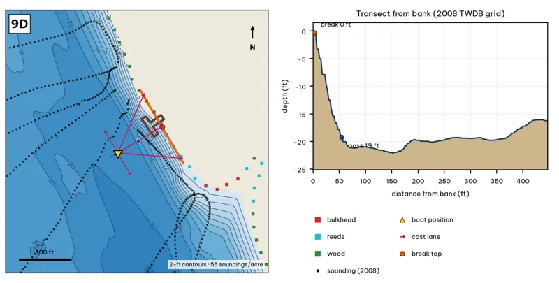
Orange line: break top. Blue dot: base of the break. Black dots: 2008 TWDB soundings. Shoreline squares: bank type (see the Bank-Type Map chapter). Contour interval: 2 ft, at 58 soundings per acre within 250 ft.
| Measure | Value |
|---|---|
| Depth at the bank | 0.3 ft (first wet grid cell, 0 ft from the OSM shoreline) analysis |
| Break top | 1.0 ft, 0 ft from the bank analysis |
| Base of the break | 19.5 ft, 58 ft from the bank analysis |
| Slope | steepest 4.4 ft per 10 ft; average 3.2 ft per 10 ft across the break analysis |
| Bank type | reeds (confidence: medium) |
| Deep-water access | 20-ft water 58 ft away; 25-ft water 864 ft away; deepest within 300 ft: 24 ft analysis |
| Data support | fair (nearest sounding 40 ft from the break) |
Why a giant would use it. The steepest bank in Reach 9: about 1 ft at the dock to 19.5 ft only 58 ft out. Bass can sit under the dock and reach 20 ft of water in a few tail kicks. Score factors: cover = dock over a 19-ft drop; forage = sunfish; pressure = moderate. inference
Wind and current. Best wind: from the WSW (blowing onto this bank) analysis. WSW wind blows onto it. Little current. inference
Sun and shade today (Oct 12). This is the NE bank of the reach. With 40-ft trees, a shade band of 25 ft or more falls on the water at: 8:05 am, 9:00 am, 10:00 am. analysis
Boat position and cast lanes. Hold over about 22 ft, roughly 102 ft off the bank (yellow triangle). Fan three casts to the break top (magenta arrows), then turn and work parallel to the break along the dashed lane inference.
Big-bass plan by season (★ = this spot is a seasonal pick) inference
- Winter / pre-spawn: 3/4 oz jig crawled down the slope off the dock ends.
- Spawn: Soft glide skipped or 'chopped' beside the dock posts so it hangs near the cover.
- ★ Summer: Skip a jig or a 7-in stick worm deep under the shade; the slope reaches 20 ft about 58 ft out.
- Fall: Swimbait along the outside edge of the dock line.
9E · Blunn Creek delta lip
#13 of 51Deep water3Cover3Forage4Low pressure3Data5Best: Spawn
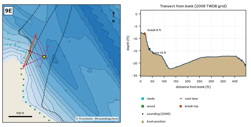
Orange line: break top. Blue dot: base of the break. Black dots: 2008 TWDB soundings. Shoreline squares: bank type (see the Bank-Type Map chapter). Contour interval: 2 ft, at 36 soundings per acre within 250 ft.
| Measure | Value |
|---|---|
| Depth at the bank | 8.1 ft (first wet grid cell, 0 ft from the OSM shoreline) analysis |
| Break top | 8.4 ft, 15 ft from the bank analysis |
| Base of the break | 14.8 ft, 42 ft from the bank analysis |
| Slope | steepest 3.1 ft per 10 ft; average 2.3 ft per 10 ft across the break analysis |
| Bank type | reeds (confidence: medium) |
| Deep-water access | 20-ft water 90 ft away; 25-ft water 529 ft away; deepest within 300 ft: 24 ft analysis |
| Data support | good (a 2008 sounding lies within 15 ft of the break) |
Why a giant would use it. Blunn Creek's delta lip: 8 ft to 15 ft within about 40 ft, with 20-ft water within 90 ft. Reeds on the delta, deep water just off it. Score factors: cover = creek delta, reeds; forage = Blunn Creek inflow; pressure = moderate. inference
Wind and current. Best wind: from the ESE (blowing onto this bank) analysis. ESE wind blows onto it. Blunn Creek is small; after storms it pushes a mud plume. inference
Sun and shade today (Oct 12). This is the SW bank of the reach. With 40-ft trees, a shade band of 25 ft or more falls on the water at: 3:00 pm, 4:00 pm, 5:00 pm, 6:00 pm, 6:30 pm. analysis
Boat position and cast lanes. Hold over about 17 ft, roughly 88 ft off the bank (yellow triangle). Fan three casts to the break top (magenta arrows), then turn and work parallel to the break along the dashed lane inference.
Big-bass plan by season (★ = this spot is a seasonal pick) inference
- Winter / pre-spawn: Jig or big Texas-rigged worm crawled down the delta slope to 15 ft, then on into the 24-ft water nearby. Go slow.
- ★ Spawn: Sight-fish from a distance in clear water: weightless soft jerkbait (Fluke) or stick worm to beds on the delta. The lake record (14.05 lb) took a Zoom Fluke from a creek in February.
- Summer: Walking bait or wake bait over the delta at dawn. After a storm, a big white spinnerbait along the mud line.
- Fall: Glide or swimbait across the delta lip (8–15 ft) as shad move toward the creek.