Reach 6 · Lamar, Pfluger and the Railroad Bridge
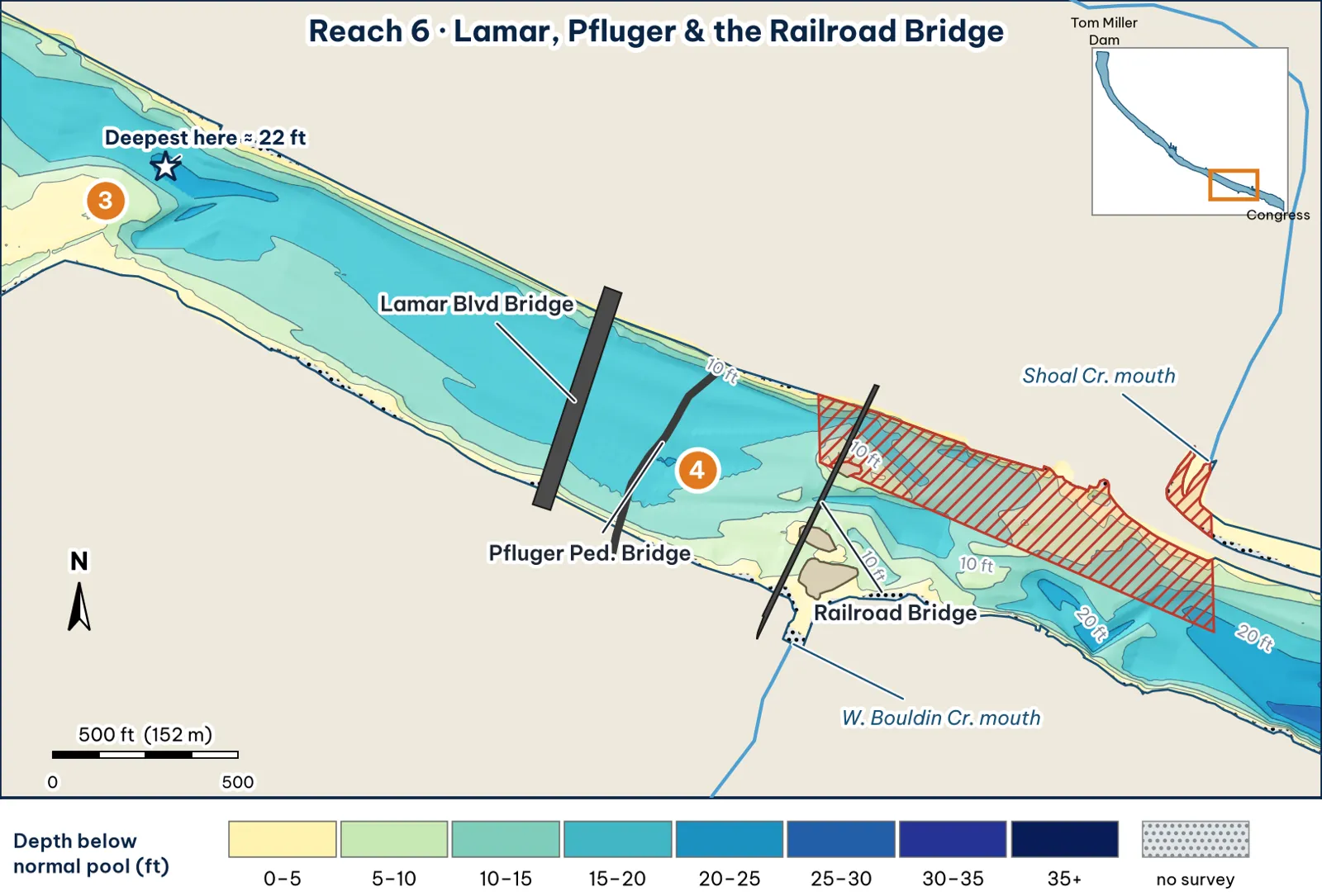
Three sets of pilings in about 700 ft of river (Lamar at 14,980 ft below the dam, Pfluger at 15,238 ft, the railroad bridge at 15,691 ft) analysis. The hatching marks the no-boat zone. The starred 22-ft cell is the Barton Creek hole at the upstream edge of this map; through the bridges, the channel runs 16–20 ft analysis.
The bottom
- The channel sits north of center analysis:
- It's about 515 ft wide, and the deepest point of each cross-section runs 16–20 ft.
- The deepest line runs about 155 ft off the north bank.
- The north bank is steep, reaching 15 ft within about 50 ft.
- The south side is a wider shelf analysis. It reaches 10 ft about 40 ft out, but 15 ft not until about 185 ft out.
- Islands. Two small islands sit on the south side near the railroad bridge, ringed by shallow water (OSM; TWDB contours).
- Pilings. TWDB found no scour holes below the bridge piers (TWDB 1999). TWDB's 2008 data also includes two bridge-column points near the railroad bridge (TWDB 2008 shapefiles).
Cover and grass
- Bridge pilings on three bridges. The guide caught bass "dropshotting the bridge pilings" (Torwick).
- Grass on the south shelf and around the islands inference.
- West Bouldin Creek comes in on the south side (OSM).
Water: clarity and current
- Clarity. This is roughly where the water changes from clear to stained. "Very clear above Lamar" (City of Austin, FY2023). Below here, Torwick found visibility dropping toward I-35 (Torwick).
- Current. Release current runs through the bridge lanes. The pilings make seams analysis.
Through the seasons
| Season | What to expect | Play analysis |
|---|---|---|
| Spring | Clearing water, and grass growing on the south shelf | Edges of the south shelf and the islands |
| Summer | Shade under three bridges | Shade lines on the pilings at midday |
| Fall | Pilings plus releases | Swimbait swung past each pier during releases. Drop-shot as a follow-up (Torwick) |
| Winter | Deep, steep north wall (inside the no-boat zone below the railroad bridge) | Jig on the deepest Lamar and Pfluger piers |
How to fish it for a giant
The Approach
- Where a giant sits. The deepest pier bases of the Lamar, Pfluger and railroad bridges, in the shade, out of the current analysis.
- Boat position. Work from the south half of each span, staying down-current of the pier you are fishing. The water below the railroad bridge on the north side is a no-boat zone analysis.
- Baits. Swing a swimbait or slow glide past each pier with current. Without current, pitch a 3/4 oz jig or a 10-in worm to the base and let it sit inference.
- Line. 20–25 lb fluorocarbon: Wired2Fish recommends fluorocarbon for durability around zebra-mussel cover and retying after contact (Wired2Fish).
Access, hazards and rules
Rule: No-boat zone
"A person may not operate a watercraft in the portion of Town Lake that is bounded by a line from the center of Town Lake to the mouth of Shoal Creek on the east, the shoreline of Town Lake on the north, the railroad bridge immediately west of Shoal Creek on the west, and center of Town Lake on the south" (City code 8-5-82). Stay south of the centerline between the railroad bridge and Shoal Creek. I read this from a posted copy of the code chapter, so confirm it's current with Lake Patrol at (512) 329-8841 unverified.
Hazard
- Rebar. There's "submerged rebar near the Lamar bridge," where a swimmer was injured in 2012, plus "bridge construction debris" (City of Austin 2020).
- Shallows. The ARC map marks "unmarked hazards (shallow)" on the south side at the railroad bridge (ARC map).
- Bring extra baits.
Pro tip
When the dam is releasing, this cluster gives you three bridges' worth of piling seams within one short drift. If a big fish follows a swimbait but won't commit, follow up on that same piling with a drop-shot, the presentation Torwick used here (analysis; Torwick).
Reach 6 Spots: Lamar, Pfluger and the railroad bridge
5 spots: 6A, 6B, 6C, 6D, 6E. Close-up maps from the 2008 survey; scores from the giant ranking.
6A · Lamar Blvd Bridge piling row
#33 of 51Deep water2Cover4Forage4Low pressure2Data3Best: Post-spawn and summer
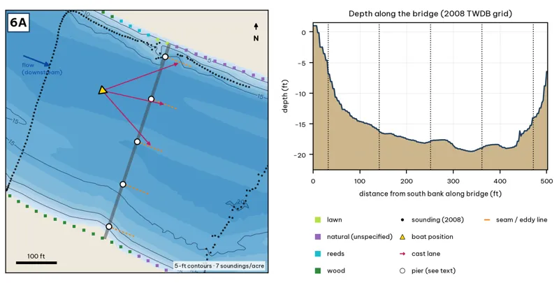
The bridge line is the OSM road or rail centerline. Pier markers are inferred from NBI span counts by assuming equal spans centered on the channel, except at the railroad bridge, where TWDB's footing outlines are used. Orange dashes show where a downstream eddy line should form during a release inference. Contours: 5-ft, at 7 soundings per acre within 250 ft.
| Measure | Value |
|---|---|
| Bridge (NBI 2025) | 6 spans, 200.9 m (659 ft), longest span 33.5 m (110 ft), concrete arch, built 1943 |
| Water width along the deck | 504 ft (2008 TWDB shoreline) analysis |
| Deepest water under the deck | 19.5 ft, 338 ft from the south end analysis |
| Deep-water access | deepest within 300 ft: 20 ft analysis |
| Data support | 7 soundings per acre; nearest sounding 207 ft from the crossing center |
Why a giant would use it. The Lamar Bridge piling row: 6 spans (NBI), a 1943 concrete arch. Piers in 15–19 ft. Score factors: cover = arch-bridge piers; forage = shad; pressure = downtown traffic. inference
Wind and current. Release seams on the downstream side. Shelter under the deck. inference
Sun and shade today (Oct 12). Shade under the deck at all hours. analysis
Boat position and cast lanes. Hold upstream of the deepest span (yellow triangle) and cast down-current to the eddy behind each pier (magenta arrows) inference.
Big-bass plan by season (★ = this spot is a seasonal pick) inference
- Winter / pre-spawn: 3/4 oz football jig or a 10-in Texas-rigged worm crawled along the pier bases in the deepest span (about 20 ft). Pause 5–10 seconds at each pier.
- Spawn: 6–8 in slow-sinking glide (sunfish or shad colors) swum past the shady side of each pier and killed beside it. Give followers the 180° turn.
- ★ Summer: The deck shades the piers all day. Pitch a 3/4 oz jig or a 10-in worm to the pier bases at first light and from dusk to the 10 pm fishing cutoff.
- Fall: 6–7 in swimbait or soft glide down the current seam past each pier when Tom Miller is releasing.
Hazard · Bridge debris Broken concrete and rebar lie under the bridges (City of Austin 2025). Expect snags.
6B · Pfluger Bridge piling row
#26 of 51Deep water3Cover3Forage3Low pressure2Data4Best: any season (not a seasonal pick)
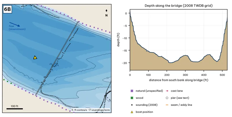
The bridge line is the OSM road or rail centerline. Pier markers are inferred from NBI span counts by assuming equal spans centered on the channel, except at the railroad bridge, where TWDB's footing outlines are used. Orange dashes show where a downstream eddy line should form during a release inference. Contours: 5-ft, at 17 soundings per acre within 250 ft.
| Measure | Value |
|---|---|
| Bridge (NBI 2025) | not in the National Bridge Inventory; pier positions not found in any public source |
| Water width along the deck | 528 ft (2008 TWDB shoreline) analysis |
| Deepest water under the deck | 20.0 ft, 220 ft from the south end analysis |
| Deep-water access | deepest within 300 ft: 20 ft analysis |
| Data support | 17 soundings per acre; nearest sounding 37 ft from the crossing center |
Why a giant would use it. Pfluger Pedestrian Bridge. It has piers, but their positions are not in any public data I found. Score factors: cover = footbridge piers; forage = shad; pressure = downtown traffic. inference
Wind and current. Release seams. Shelter. inference
Sun and shade today (Oct 12). Shade under the deck at all hours. analysis
Boat position and cast lanes. Hold upstream of the deepest span (yellow triangle) and cast down-current to the eddy behind each pier (magenta arrows) inference.
Big-bass plan by season (★ = this spot is a seasonal pick) inference
- Winter / pre-spawn: 3/4 oz football jig or a 10-in Texas-rigged worm crawled along the pier bases in the deepest span (about 20 ft). Pause 5–10 seconds at each pier.
- Spawn: 6–8 in slow-sinking glide (sunfish or shad colors) swum past the shady side of each pier and killed beside it. Give followers the 180° turn.
- Summer: The deck shades the piers all day. Pitch a 3/4 oz jig or a 10-in worm to the pier bases at first light and from dusk to the 10 pm fishing cutoff.
- Fall: 6–7 in swimbait or soft glide down the current seam past each pier when Tom Miller is releasing.
6C · Railroad bridge and islands
#27 of 51Deep water2Cover4Forage3Low pressure2Data5Best: any season (not a seasonal pick)
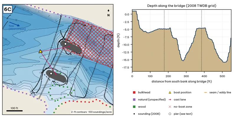
The bridge line is the OSM road or rail centerline. Pier markers are inferred from NBI span counts by assuming equal spans centered on the channel, except at the railroad bridge, where TWDB's footing outlines are used. Orange dashes show where a downstream eddy line should form during a release inference. Contours: 2-ft, at 103 soundings per acre within 250 ft.
| Measure | Value |
|---|---|
| Bridge (NBI 2025) | not in the National Bridge Inventory; TWDB's 2008 survey maps two pier/footing outlines (shown dark gray) |
| Water width along the deck | 552 ft (2008 TWDB shoreline) analysis |
| Deepest water under the deck | 15.4 ft, 282 ft from the south end analysis |
| Deep-water access | deepest within 300 ft: 18 ft analysis |
| Data support | 103 soundings per acre; nearest sounding 27 ft from the crossing center |
Why a giant would use it. The railroad bridge. TWDB maps two pier footprints with a 15-ft channel between them. The islands give current breaks. Score factors: cover = rail piers, island tips; forage = shad; pressure = downtown traffic; no-boat zone nearby. inference
Wind and current. Releases make strong seams at the footprints. Sheltered. inference
Sun and shade today (Oct 12). Shade under the deck at all hours. analysis
Boat position and cast lanes. Hold upstream of the deepest span (yellow triangle) and cast down-current to the eddy behind each pier (magenta arrows) inference.
Big-bass plan by season (★ = this spot is a seasonal pick) inference
- Winter / pre-spawn: 3/4 oz football jig or a 10-in Texas-rigged worm crawled along the pier bases in the deepest span (about 15 ft). Pause 5–10 seconds at each pier.
- Spawn: 6–8 in slow-sinking glide (sunfish or shad colors) swum past the shady side of each pier and killed beside it. Give followers the 180° turn.
- Summer: The deck shades the piers all day. Pitch a 3/4 oz jig or a 10-in worm to the pier bases at first light and from dusk to the 10 pm fishing cutoff.
- Fall: 6–7 in swimbait or soft glide down the current seam past each pier when Tom Miller is releasing.
No-boat zone
The red hatching marks the City no-boat zone: north of the centerline, between the railroad bridge and the Shoal Creek mouth (City code 8-5-82). The zone outline here is approximate analysis. Keep the boat south and east of it.
Hazard · Bridge debris Broken concrete and rebar lie under the bridges (City of Austin 2025). Expect snags.
6D · West Bouldin Creek mouth and south shelf
#42 of 51Deep water1Cover3Forage4Low pressure2Data5Best: Fall
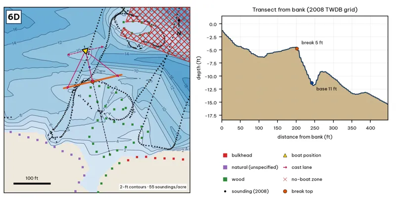
Orange line: break top. Blue dot: base of the break. Black dots: 2008 TWDB soundings. Shoreline squares: bank type (see the Bank-Type Map chapter). Contour interval: 2 ft, at 55 soundings per acre within 250 ft.
| Measure | Value |
|---|---|
| Depth at the bank | 1.3 ft (first wet grid cell, 0 ft from the OSM shoreline) analysis |
| Break top | 4.9 ft, 200 ft from the bank analysis |
| Base of the break | 10.9 ft, 240 ft from the bank analysis |
| Slope | steepest 1.9 ft per 10 ft; average 1.5 ft per 10 ft across the break analysis |
| Bank type | wood (confidence: low-medium) |
| Deep-water access | 20-ft water 524 ft away; 25-ft water 1239 ft away; deepest within 300 ft: 19 ft analysis |
| Data support | good (a 2008 sounding lies within 15 ft of the break) |
Why a giant would use it. The West Bouldin Creek mouth (OSM weir) and the south shelf, which breaks from about 5 to 11 ft about 200–240 ft out. Score factors: cover = creek mouth, weir; forage = creek inflow; pressure = downtown traffic. inference
Wind and current. Best wind: from the NNW (blowing onto this bank) analysis. An NNW wind blows onto it. Creek inflow after rain. inference
Sun and shade today (Oct 12). This is the S bank of the reach. With 40-ft trees, a shade band of 25 ft or more falls on the water at: 1:00 pm, 2:00 pm, 3:00 pm, 4:00 pm, 5:00 pm, 6:00 pm, 6:30 pm. analysis
Boat position and cast lanes. Hold over about 13 ft, roughly 285 ft off the bank (yellow triangle). Fan three casts to the break top (magenta arrows), then turn and work parallel to the break along the dashed lane inference.
Big-bass plan by season (★ = this spot is a seasonal pick) inference
- Winter / pre-spawn: Jig or big Texas-rigged worm crawled down the delta slope to 11 ft, then on into the 19-ft water nearby. Go slow.
- Spawn: Sight-fish from a distance in clear water: weightless soft jerkbait (Fluke) or stick worm to beds on the delta. The lake record (14.05 lb) took a Zoom Fluke from a creek in February.
- Summer: Walking bait or wake bait over the delta at dawn. After a storm, a big white spinnerbait along the mud line.
- ★ Fall: Glide or swimbait across the delta lip (5–11 ft) as shad move toward the creek.
6E · North channel wall at Lamar
#43 of 51Deep water2Cover3Forage3Low pressure2Data4Best: any season (not a seasonal pick)
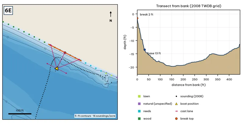
Orange line: break top. Blue dot: base of the break. Black dots: 2008 TWDB soundings. Shoreline squares: bank type (see the Bank-Type Map chapter). Contour interval: 5 ft, at 16 soundings per acre within 250 ft.
| Measure | Value |
|---|---|
| Depth at the bank | 1.6 ft (first wet grid cell, 0 ft from the OSM shoreline) analysis |
| Break top | 2.9 ft, 0 ft from the bank analysis |
| Base of the break | 14.1 ft, 38 ft from the bank analysis |
| Slope | steepest 3.6 ft per 10 ft; average 3.0 ft per 10 ft across the break analysis |
| Bank type | wood (confidence: low-medium) |
| Deep-water access | 20-ft water 603 ft away; 25-ft water 2298 ft away; deepest within 300 ft: 20 ft analysis |
| Data support | fair (nearest sounding 29 ft from the break) |
Why a giant would use it. The north channel wall at Lamar: from about 2 to 13 ft within 32 ft. Score factors: cover = channel wall; forage = sunfish; pressure = downtown traffic. inference
Wind and current. Best wind: from the SSW (blowing onto this bank) analysis. A SSW wind blows onto it. Moderate current. inference
Sun and shade today (Oct 12). This is the N bank of the reach. With 40-ft trees, a shade band of 25 ft or more falls on the water at: 8:05 am. analysis
Boat position and cast lanes. Hold over about 16 ft, roughly 82 ft off the bank (yellow triangle). Fan three casts to the break top (magenta arrows), then turn and work parallel to the break along the dashed lane inference.
Big-bass plan by season (★ = this spot is a seasonal pick) inference
- Winter / pre-spawn: 3/4–1 oz football jig or 10-in Texas-rigged worm dragged down the face from 3 to 14 ft, then on into the 20-ft water. Long pauses.
- Spawn: Slow-sinking glide counted down to the break top (3 ft), swum along it and killed at the edge.
- Summer: Walking topwater or wake bait along the bank in the first and last hour; a 10–12 in worm on the 14-ft base in between.
- Fall: Swimbait or glide run parallel to the break top as shad push up.