Reach 5 · Barton Creek Mouth
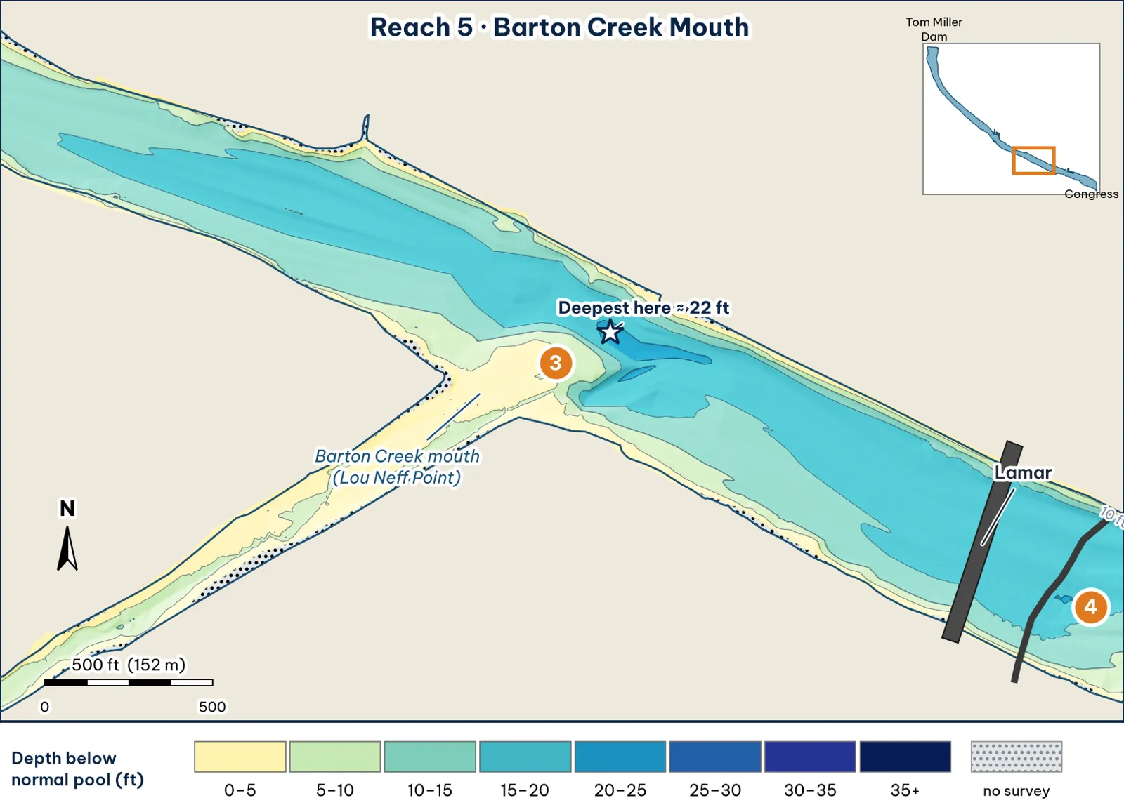
Barton Creek mouth (Lou Neff Point). The channel crosses to the north bank, leaving a wide, shallow flat off the creek mouth.
The bottom
- The channel crosses to the north bank analysis:
- It's about 470–620 ft wide, and the deepest point of each cross-section runs 17–22 ft.
- The deepest line runs about 150 ft off the north bank.
- The deepest cell, about 22 ft, sits about 2.6 miles below the dam, just below the creek mouth.
-
The Barton flat (the south side, off the creek mouth) analysis:
- 5 ft about 30 ft out from the south bank.
- 10 ft about 90 ft out.
- 15 ft about 230 ft out.
The sample cross-section shows a shelf about 5 ft deep that's roughly 250 ft wide, then a sharp drop to 18–19 ft. - The Barton Creek arm. In the 2008 grid, it's mostly 4–5 ft deep (median), reaching about 7 ft in most places and 12.5 ft at its deepest analysis. TWDB surveyed it in 2008 (TWDB 2008). In 1999, TWDB noted "shoaling and sediment deposition" at creek mouths (TWDB 1999). Barton Creek carries about 93 million pounds of suspended sediment a year, mostly in big storms (City of Austin, Barton Creek study).
Cover and grass
- The historic center of the grass. In 2013, "dense growths of fanwort... traversed the width of Lady Bird Reservoir at the confluence of Barton Springs Creek" (TPWD 2019). Fanwort grows in Barton Creek today (City of Austin, FY2024–25).
- Bank plants. Giant reed is abundant at "the mouths of Barton and Waller Creeks" (City plant page).
Water: clarity, temperature and current
- Spring water. Barton Springs runs about 71–72°F year-round. USGS daily averages stayed between 21.5 and 22.1°C all of 2025, and the gauge read 22.1°C (71.8°F) and 21 cfs at 11:00 am CT on Oct 12, 2026 (USGS 08155500). The City still says "68–70" (City of Austin). TPWD says Barton Creek "remains warm during the winter" (TPWD).
- Spring flow. TPWD gives a long-term average of 32 million gallons a day, about 50 cfs (TPWD paddling trail; analysis unit conversion). At today's 21 cfs, the warm plume is small.
- Clarity. Clear. The guide found clear water and healthy grass "around Barton Springs" (Torwick).
- After rain. It turns muddy only after big storms. Rains of an inch or more after dry spells "may not generate runoff" (City Barton Creek study).
Through the seasons
| Season | What to expect | Play analysis |
|---|---|---|
| Spring | The spring-fed flat warms early | Edge of the flat, where 5 ft drops to 15 ft |
| Summer | 71–72°F spring water is cooler than an 80°F+ lake | The creek-mouth plume at dawn |
| Fall | Lake and springs are near the same temperature until the fronts come | Grass edge on the flat lip. Strong when the water first cools |
| Winter | The creek "remains warm" (TPWD) | The cold-front refuge. Jig or big worm on the drop |
How to fish it for a giant
The Approach
- Where a giant sits. The lip of the Barton flat, where 5 ft drops to 15 ft, and the creek-mouth plume in cold weather (the creek "remains warm," per TPWD) analysis.
- Boat position. Out in about 18 ft, roughly 250 ft off the south bank. Cast up onto the flat and bring the bait back down the drop analysis.
- Baits. Pre-spawn: a slow-sinking glide counted down to the lip and killed at the drop. Winter: a jig or big worm on the drop below the plume. Spawn: sight-fishing on the flat (stay back; clear water) inference.
- Line. 20 lb fluorocarbon analysis.
Access, hazards and rules
- Access. Zilker Park Boat Rentals is on Barton Creek (TPWD paddling trail).
Hazard
- Canoes. The ARC map warns "Be alert for canoes in this area" at the creek mouth (ARC map).
- Algae. The "backwater area between the lake and Barton Springs pool" has had toxic algae mats (City of Austin).
Rule
Dogs may swim in Barton Creek between the lake and Barton Springs Pool (City code 8-5-49, quoted in City of Austin 2020). People may not swim or wade anywhere in the lake.
Reach 5 Spots: Barton Creek mouth
3 spots: 5A, 5B, 5C. Close-up maps from the 2008 survey; scores from the giant ranking.
5A · Barton flat lip
#41 of 51Deep water2Cover2Forage4Low pressure2Data4Best: any season (not a seasonal pick)
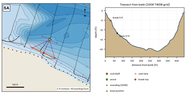
Orange line: break top. Blue dot: base of the break. Black dots: 2008 TWDB soundings. Shoreline squares: bank type (see the Bank-Type Map chapter). Contour interval: 2 ft, at 46 soundings per acre within 250 ft.
| Measure | Value |
|---|---|
| Depth at the bank | 0.8 ft (first wet grid cell, 0 ft from the OSM shoreline) analysis |
| Break top | 1.3 ft, 0 ft from the bank analysis |
| Base of the break | 12.6 ft, 78 ft from the bank analysis |
| Slope | steepest 2.1 ft per 10 ft; average 1.5 ft per 10 ft across the break analysis |
| Bank type | rock bluff (confidence: medium) |
| Deep-water access | 20-ft water 182 ft away; 25-ft water 3174 ft away; deepest within 300 ft: 22 ft analysis |
| Data support | fair (nearest sounding 16 ft from the break) |
Why a giant would use it. The lip of the Barton flat: about 5 ft at 30 ft from the bank, falling to about 12 ft at 68 ft, then the 20-ft channel. Rock bluff (TPWD). Barton spring water (71–72°F) flows across it. Score factors: cover = flat lip (grass when present); forage = spring-fed flat bait; pressure = Zilker paddle traffic. inference
Wind and current. Best wind: from the NNE (blowing onto this bank) analysis. An NNE wind blows onto it. Barton inflow plus lake current. inference
Sun and shade today (Oct 12). This is the SW bank of the reach. With 40-ft trees, a shade band of 25 ft or more falls on the water at: 1:00 pm, 2:00 pm, 3:00 pm, 4:00 pm, 5:00 pm, 6:00 pm, 6:30 pm. analysis
Boat position and cast lanes. Hold over about 15 ft, roughly 122 ft off the bank (yellow triangle). Fan three casts to the break top (magenta arrows), then turn and work parallel to the break along the dashed lane inference.
Big-bass plan by season (★ = this spot is a seasonal pick) inference
- Winter / pre-spawn: Suspending jerkbait or a 3/4 oz jig worked slowly off the edge at about 13 ft.
- Spawn: Wake bait or slow glide over the flat, then let it fall off the 1-ft edge, where pre-spawn females stage.
- Summer: Big walking topwater over the flat at dawn and dusk; a 10–12 in worm dragged along the 1–13 ft edge after sun-up.
- Fall: Swimbait run parallel to the edge, best when wind blows onto the flat.
5B · Barton Creek mouth delta
#46 of 51Deep water1Cover3Forage5Low pressure1Data4Best: Spawn
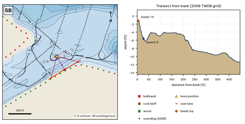
Orange line: break top. Blue dot: base of the break. Black dots: 2008 TWDB soundings. Shoreline squares: bank type (see the Bank-Type Map chapter). Contour interval: 2 ft, at 88 soundings per acre within 250 ft.
| Measure | Value |
|---|---|
| Depth at the bank | 1.2 ft (first wet grid cell, 2 ft from the OSM shoreline) analysis |
| Break top | 1.5 ft, 2 ft from the bank analysis |
| Base of the break | 5.7 ft, 30 ft from the bank analysis |
| Slope | steepest 2.1 ft per 10 ft; average 1.5 ft per 10 ft across the break analysis |
| Bank type | wood (confidence: low-medium) |
| Deep-water access | 20-ft water 384 ft away; 25-ft water 3500 ft away; deepest within 300 ft: 18 ft analysis |
| Data support | fair (nearest sounding 49 ft from the break) |
Why a giant would use it. The Barton Creek mouth delta. Coarse sediment (City 2025). Spring water and a creek plume. Score factors: cover = creek delta; forage = warm spring water; bait; pressure = very heavy paddle traffic. inference
Wind and current. Best wind: from the NNW (blowing onto this bank) analysis. An NNW wind blows into it. Barton inflow. inference
Sun and shade today (Oct 12). This is the SW bank of the reach. With 40-ft trees, a shade band of 25 ft or more falls on the water at: 1:00 pm, 2:00 pm, 3:00 pm, 4:00 pm, 5:00 pm, 6:00 pm, 6:30 pm. analysis
Boat position and cast lanes. Hold over about 8 ft, roughly 75 ft off the bank (yellow triangle). Fan three casts to the break top (magenta arrows), then turn and work parallel to the break along the dashed lane inference.
Big-bass plan by season (★ = this spot is a seasonal pick) inference
- Winter / pre-spawn: Jig or big Texas-rigged worm crawled down the delta slope to 6 ft, then on into the 18-ft water nearby. Go slow.
- ★ Spawn: Sight-fish from a distance in clear water: weightless soft jerkbait (Fluke) or stick worm to beds on the delta. The lake record (14.05 lb) took a Zoom Fluke from a creek in February.
- Summer: Walking bait or wake bait over the delta at dawn. After a storm, a big white spinnerbait along the mud line.
- Fall: Glide or swimbait across the delta lip (1–6 ft) as shad move toward the creek.
5C · North wall into the 22-ft hole
#25 of 51Deep water3Cover3Forage3Low pressure2Data4Best: Fall
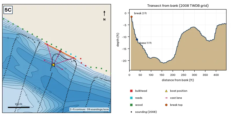
Orange line: break top. Blue dot: base of the break. Black dots: 2008 TWDB soundings. Shoreline squares: bank type (see the Bank-Type Map chapter). Contour interval: 2 ft, at 39 soundings per acre within 250 ft.
| Measure | Value |
|---|---|
| Depth at the bank | 1.6 ft (first wet grid cell, 8 ft from the OSM shoreline) analysis |
| Break top | 2.6 ft, 8 ft from the bank analysis |
| Base of the break | 11.9 ft, 40 ft from the bank analysis |
| Slope | steepest 3.9 ft per 10 ft; average 2.9 ft per 10 ft across the break analysis |
| Bank type | wood (confidence: low-medium) |
| Deep-water access | 20-ft water 139 ft away; 25-ft water 3328 ft away; deepest within 300 ft: 22 ft analysis |
| Data support | fair (nearest sounding 18 ft from the break) |
Why a giant would use it. The north wall into the 22-ft hole: from about 2 to 11 ft within 35 ft, then down to the hole. Score factors: cover = wooded wall; forage = sunfish; pressure = heavy traffic. inference
Wind and current. Best wind: from the SSW (blowing onto this bank) analysis. A SSW wind blows onto it, often. Moderate current. inference
Sun and shade today (Oct 12). This is the NE bank of the reach. With 40-ft trees, a shade band of 25 ft or more falls on the water at: 8:05 am. analysis
Boat position and cast lanes. Hold over about 14 ft, roughly 85 ft off the bank (yellow triangle). Fan three casts to the break top (magenta arrows), then turn and work parallel to the break along the dashed lane inference.
Big-bass plan by season (★ = this spot is a seasonal pick) inference
- Winter / pre-spawn: 3/4–1 oz football jig or 10-in Texas-rigged worm dragged down the face from 3 to 12 ft, then on into the 22-ft water. Long pauses.
- Spawn: Slow-sinking glide counted down to the break top (3 ft), swum along it and killed at the edge.
- Summer: Walking topwater or wake bait along the bank in the first and last hour; a 10–12 in worm on the 12-ft base in between.
- ★ Fall: Swimbait or glide run parallel to the break top as shad push up.