Reach 11 · Festival Beach to the Holly Bend
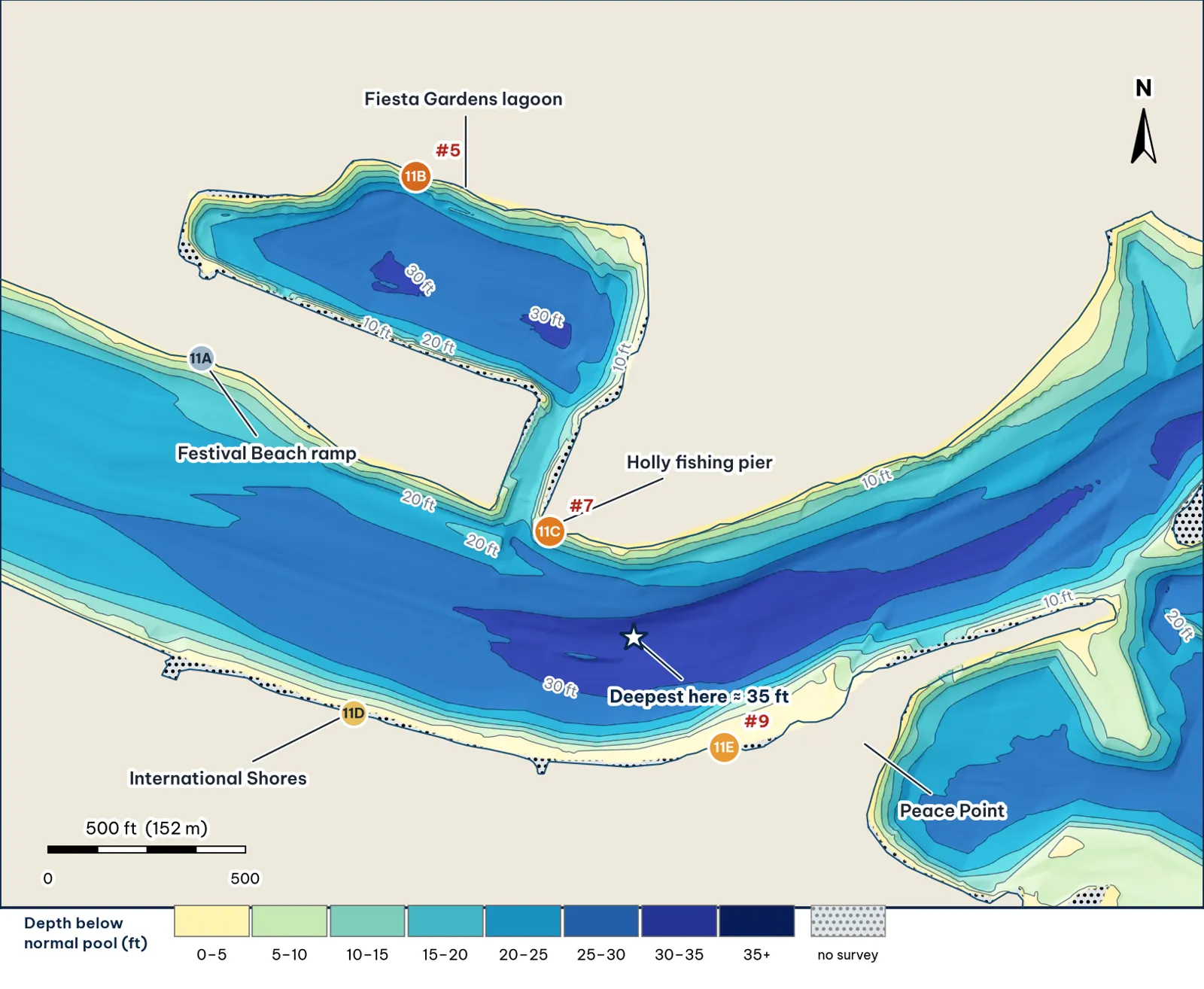
Festival Beach, the Fiesta Gardens lagoon and the bend at Holly, where the deepest water in Lady Bird lies. Depths from my grid of TWDB 2008 points analysis.
The bottom analysis
- The deepest water on the lake. About 35 ft at the Holly bend (11C), with the median deepest point of each cross-section at about 30 ft.
- The Fiesta Gardens lagoon is an enclosed basin about 30 ft deep, joined to the lake by a narrow channel near the Holly pier. Its north wall drops from about 3 ft to 24 ft within 48 ft (11B).
- The south bank slopes to 25–29 ft within about 110–150 ft at International Shores (11D) and Peace Point (11E).
Cover and forage
- Piers, docks and bulkheads on both banks; the Holly fishing pier at the lagoon mouth (11C) analysis.
- Shad over deep water inference. TPWD's 2019 survey found gizzard shad the second most common forage (TPWD 2019).
- Sparse soundings. Several spots here rely on interpolated depths between survey lines; check with your graph unverified.
Through the seasons inference
| Season | Giant play |
|---|---|
| Winter / pre-spawn | Lagoon (11B) and the 35-ft hole at 11C: football jig, long pauses |
| Spawn | The lagoon's shallow edges, if boats can reach them unverified |
| Summer | 11D and 11E pier shade and the 25–29 ft drops at dawn and dusk |
| Fall | Swimbait along the south-bank drops as shad push up |
How to fish it for a giant
The Approach
- The deep bend. Work a jig down the 11E and 11C slopes into 30–35 ft. This is the deepest water on the lake, so it is a winter and mid-summer refuge inference.
- The lagoon. Fish the steep north wall with a jig or big worm, and run a glide along it in low light inference.
- Line. 20 lb fluorocarbon analysis.
Access, hazards and rules
- Festival Beach ramp: one lane, parking for about 5 trailers (TPWD access).
- Lagoon access by boat through the channel near the Holly pier is unconfirmed; check for low bridges or barriers before you go unverified.
Reach 11 Spots: Festival Beach, Fiesta Gardens lagoon and the Holly bend
5 spots: 11A, 11B, 11C, 11D, 11E. Close-up maps from the 2008 survey; scores from the giant ranking.
11A · Festival Beach ramp point
#48 of 51Deep water3Cover3Forage3Low pressure1Data2Best: any season (not a seasonal pick)
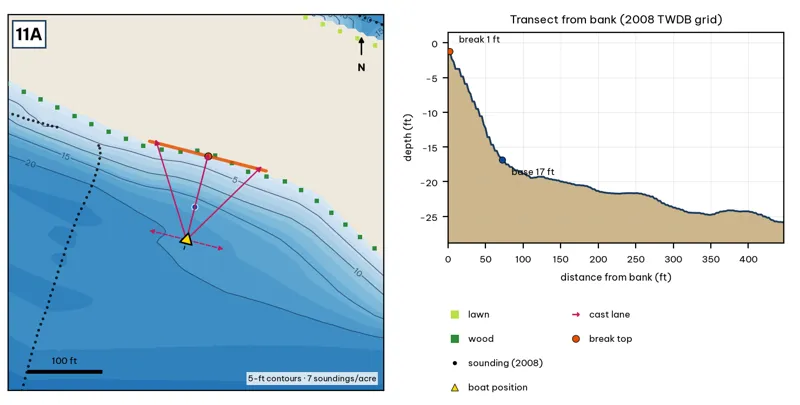
Orange line: break top. Blue dot: base of the break. Black dots: 2008 TWDB soundings. Shoreline squares: bank type (see the Bank-Type Map chapter). Contour interval: 5 ft, at 7 soundings per acre within 250 ft.
| Measure | Value |
|---|---|
| Depth at the bank | 1.3 ft (first wet grid cell, 0 ft from the OSM shoreline) analysis |
| Break top | 1.8 ft, 0 ft from the bank analysis |
| Base of the break | 17.3 ft, 78 ft from the bank analysis |
| Slope | steepest 2.6 ft per 10 ft; average 2.0 ft per 10 ft across the break analysis |
| Bank type | wood (confidence: low-medium) |
| Deep-water access | 20-ft water 114 ft away; 25-ft water 302 ft away; deepest within 300 ft: 25 ft analysis |
| Data support | low (nearest sounding 144 ft away; the break is interpolated) |
Why a giant would use it. The Festival Beach ramp point slopes to about 17 ft at 78 ft out, with 25-ft water about 300 ft out. It is the easiest launch for the east end of the lake, so it gets fished hard from the bank. Score factors: cover = ramp point; forage = sunfish; pressure = Festival Beach bank anglers. inference
Wind and current. Best wind: from the SSW (blowing onto this bank) analysis. SSW wind blows onto it. Slight current. inference
Sun and shade today (Oct 12). This is the N bank of the reach. With 40-ft trees it gets little shade today. analysis
Boat position and cast lanes. Hold over about 19 ft, roughly 122 ft off the bank (yellow triangle). Fan three casts to the break top (magenta arrows), then turn and work parallel to the break along the dashed lane inference.
Big-bass plan by season (★ = this spot is a seasonal pick) inference
- Winter / pre-spawn: 3/4–1 oz football jig or 10-in Texas-rigged worm dragged down the face from 2 to 17 ft, then on into the 25-ft water. Long pauses.
- Spawn: Slow-sinking glide counted down to the break top (2 ft), swum along it and killed at the edge.
- Summer: Walking topwater or wake bait along the bank in the first and last hour; a 10–12 in worm on the 17-ft base in between.
- Fall: Swimbait or glide run parallel to the break top as shad push up.
11B · Fiesta Gardens lagoon 30-ft hole
#5 of 51Deep water5Cover3Forage4Low pressure4Data4Best: Winter and pre-spawn · Spawn
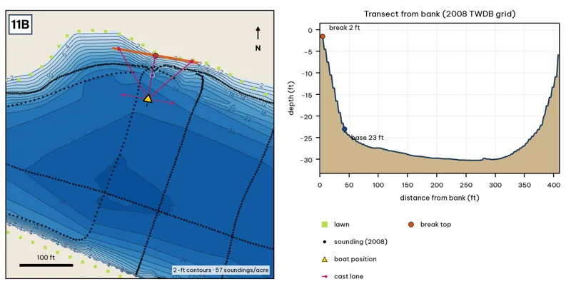
Orange line: break top. Blue dot: base of the break. Black dots: 2008 TWDB soundings. Shoreline squares: bank type (see the Bank-Type Map chapter). Contour interval: 2 ft, at 57 soundings per acre within 250 ft.
| Measure | Value |
|---|---|
| Depth at the bank | 1.6 ft (first wet grid cell, 2 ft from the OSM shoreline) analysis |
| Break top | 2.9 ft, 2 ft from the bank analysis |
| Base of the break | 23.9 ft, 48 ft from the bank analysis |
| Slope | steepest 6.0 ft per 10 ft; average 4.7 ft per 10 ft across the break analysis |
| Bank type | lawn (confidence: low-medium) |
| Deep-water access | 20-ft water 36 ft away; 25-ft water 56 ft away; deepest within 300 ft: 30 ft analysis |
| Data support | fair (nearest sounding 24 ft from the break) |
Why a giant would use it. The Fiesta Gardens lagoon is an enclosed basin about 30 ft deep, joined to the lake by a narrow channel near the Holly pier. Its north wall drops from about 3 ft to 24 ft within 48 ft. Enclosed, deep and quiet water can hold resident big fish. Score factors: cover = enclosed lagoon; forage = sunfish, shad trapped in lagoon; pressure = little boat traffic. inference
Wind and current. Best wind: from the S (blowing onto this bank) analysis. Sheltered from almost every wind; an S wind blows onto the north wall. No current. The channel mouth is the only exchange point. inference
Sun and shade today (Oct 12). This is the N bank of the reach. With 40-ft trees it gets little shade today. analysis
Boat position and cast lanes. Hold over about 26 ft, roughly 92 ft off the bank (yellow triangle). Fan three casts to the break top (magenta arrows), then turn and work parallel to the break along the dashed lane inference.
Big-bass plan by season (★ = this spot is a seasonal pick) inference
- ★ Winter / pre-spawn: 3/4–1 oz football jig or 10-in Texas-rigged worm dragged down the face from 3 to 24 ft, then on into the 30-ft water. Long pauses.
- ★ Spawn: Slow-sinking glide counted down to the break top (3 ft), swum along it and killed at the edge.
- Summer: Walking topwater or wake bait along the bank in the first and last hour; a 10–12 in worm on the 24-ft base in between.
- Fall: Swimbait or glide run parallel to the break top as shad push up.
11C · Holly pier to the 35-ft hole (deepest water in the lake)
#7 of 51Deep water5Cover4Forage4Low pressure2Data4Best: Winter and pre-spawn
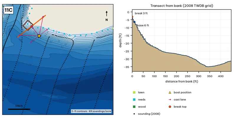
Orange line: break top. Blue dot: base of the break. Black dots: 2008 TWDB soundings. Shoreline squares: bank type (see the Bank-Type Map chapter). Contour interval: 2 ft, at 69 soundings per acre within 250 ft.
| Measure | Value |
|---|---|
| Depth at the bank | 3.2 ft (first wet grid cell, 0 ft from the OSM shoreline) analysis |
| Break top | 4.2 ft, 0 ft from the bank analysis |
| Base of the break | 20.5 ft, 75 ft from the bank analysis |
| Slope | steepest 3.0 ft per 10 ft; average 2.2 ft per 10 ft across the break analysis |
| Bank type | reeds (confidence: medium) |
| Deep-water access | 20-ft water 41 ft away; 25-ft water 64 ft away; deepest within 300 ft: 34 ft analysis |
| Data support | fair (nearest sounding 44 ft from the break) |
Why a giant would use it. The Holly fishing pier sits at the lagoon channel mouth, on the edge of the deepest water in the lake (about 35 ft, roughly 340 ft out). The bank slopes steadily to 20 ft at 75 ft out. Score factors: cover = pier over the deepest hole; forage = shad over deep water; pressure = Holly pier bank anglers. inference
Wind and current. Best wind: from the SE (blowing onto this bank) analysis. SE wind blows onto it. The lagoon channel exchanges water slowly; the main-lake current is weak. inference
Sun and shade today (Oct 12). This is the N bank of the reach. With 40-ft trees it gets little shade today. analysis
Boat position and cast lanes. Hold over about 23 ft, roughly 120 ft off the bank (yellow triangle). Fan three casts to the break top (magenta arrows), then turn and work parallel to the break along the dashed lane inference.
Big-bass plan by season (★ = this spot is a seasonal pick) inference
- ★ Winter / pre-spawn: 3/4 oz jig crawled down the slope off the dock ends.
- Spawn: Soft glide skipped or 'chopped' beside the dock posts so it hangs near the cover.
- Summer: Skip a jig or a 7-in stick worm deep under the shade; the slope reaches 21 ft about 75 ft out.
- Fall: Swimbait along the outside edge of the dock line.
11D · International Shores pier drop (south bank)
#22 of 51Deep water4Cover4Forage3Low pressure3Data1Best: Post-spawn and summer
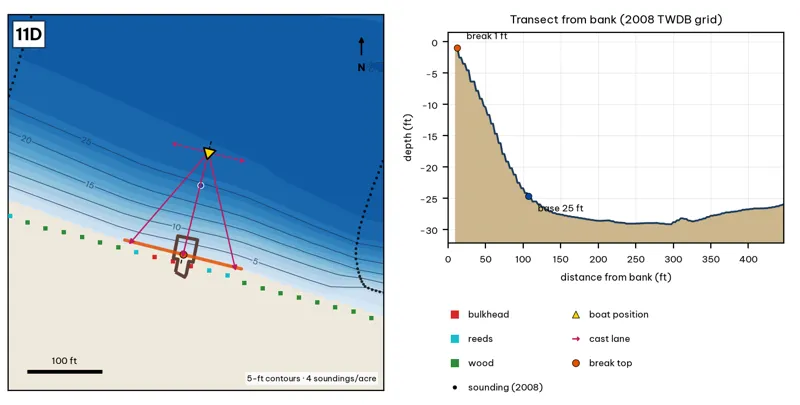
Orange line: break top. Blue dot: base of the break. Black dots: 2008 TWDB soundings. Shoreline squares: bank type (see the Bank-Type Map chapter). Contour interval: 5 ft, at 4 soundings per acre within 250 ft.
| Measure | Value |
|---|---|
| Depth at the bank | 1.0 ft (first wet grid cell, 10 ft from the OSM shoreline) analysis |
| Break top | 1.6 ft, 10 ft from the bank analysis |
| Base of the break | 25.2 ft, 112 ft from the bank analysis |
| Slope | steepest 3.1 ft per 10 ft; average 2.3 ft per 10 ft across the break analysis |
| Bank type | bulkhead (confidence: medium) |
| Deep-water access | 20-ft water 82 ft away; 25-ft water 109 ft away; deepest within 300 ft: 30 ft analysis |
| Data support | low (nearest sounding 230 ft away; the break is interpolated) |
Why a giant would use it. International Shores: a pier and bulkhead on the south bank, with a long slope to about 25 ft 110 ft out. Score factors: cover = pier, bulkhead; forage = sunfish; pressure = moderate. inference
Wind and current. Best wind: from the NNE (blowing onto this bank) analysis. NNE wind blows onto it. Slight current. inference
Sun and shade today (Oct 12). This is the S bank of the reach. With 40-ft trees, a shade band of 25 ft or more falls on the water at: 8:05 am, 9:00 am, 10:00 am, 11:00 am, 12:00 pm, 1:00 pm, 2:00 pm, 3:00 pm, 4:00 pm, 5:00 pm, 6:00 pm, 6:30 pm. analysis
Boat position and cast lanes. Hold over about 27 ft, roughly 158 ft off the bank (yellow triangle). Fan three casts to the break top (magenta arrows), then turn and work parallel to the break along the dashed lane inference.
Big-bass plan by season (★ = this spot is a seasonal pick) inference
- Winter / pre-spawn: 3/4 oz jig crawled down the slope off the dock ends.
- Spawn: Soft glide skipped or 'chopped' beside the dock posts so it hangs near the cover.
- ★ Summer: Skip a jig or a 7-in stick worm deep under the shade; the slope reaches 25 ft about 112 ft out.
- Fall: Swimbait along the outside edge of the dock line.
11E · Peace Point dock drop (south bank)
#9 of 51Deep water4Cover3Forage3Low pressure3Data5Best: Post-spawn and summer
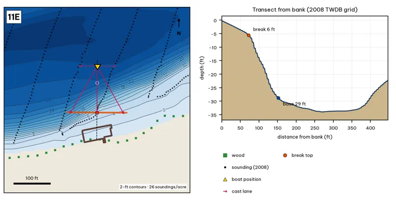
Orange line: break top. Blue dot: base of the break. Black dots: 2008 TWDB soundings. Shoreline squares: bank type (see the Bank-Type Map chapter). Contour interval: 2 ft, at 26 soundings per acre within 250 ft.
| Measure | Value |
|---|---|
| Depth at the bank | 0.1 ft (first wet grid cell, 0 ft from the OSM shoreline) analysis |
| Break top | 5.4 ft, 70 ft from the bank analysis |
| Base of the break | 28.8 ft, 152 ft from the bank analysis |
| Slope | steepest 3.6 ft per 10 ft; average 2.8 ft per 10 ft across the break analysis |
| Bank type | wood (confidence: low-medium) |
| Deep-water access | 20-ft water 105 ft away; 25-ft water 123 ft away; deepest within 300 ft: 35 ft analysis |
| Data support | good (a 2008 sounding lies within 15 ft of the break) |
Why a giant would use it. Peace Point dock: a wooded south bank that runs out to a 5-ft shelf, then falls to about 29 ft 150 ft out. It sits beside the 34–35 ft hole. Score factors: cover = dock, wooded bank; forage = sunfish; pressure = moderate. inference
Wind and current. Best wind: from the N (blowing onto this bank) analysis. N wind blows onto it. Slight current. inference
Sun and shade today (Oct 12). This is the S bank of the reach. With 40-ft trees, a shade band of 25 ft or more falls on the water at: 8:05 am, 9:00 am, 10:00 am, 11:00 am, 12:00 pm, 1:00 pm, 2:00 pm, 3:00 pm, 4:00 pm, 5:00 pm, 6:00 pm, 6:30 pm. analysis
Boat position and cast lanes. Hold over about 31 ft, roughly 198 ft off the bank (yellow triangle). Fan three casts to the break top (magenta arrows), then turn and work parallel to the break along the dashed lane inference.
Big-bass plan by season (★ = this spot is a seasonal pick) inference
- Winter / pre-spawn: 3/4 oz jig crawled down the slope off the dock ends.
- Spawn: Soft glide skipped or 'chopped' beside the dock posts so it hangs near the cover.
- ★ Summer: Skip a jig or a 7-in stick worm deep under the shade; the slope reaches 29 ft about 152 ft out.
- Fall: Swimbait along the outside edge of the dock line.