Reach 1 · Tom Miller Tailrace and Red Bud Isle
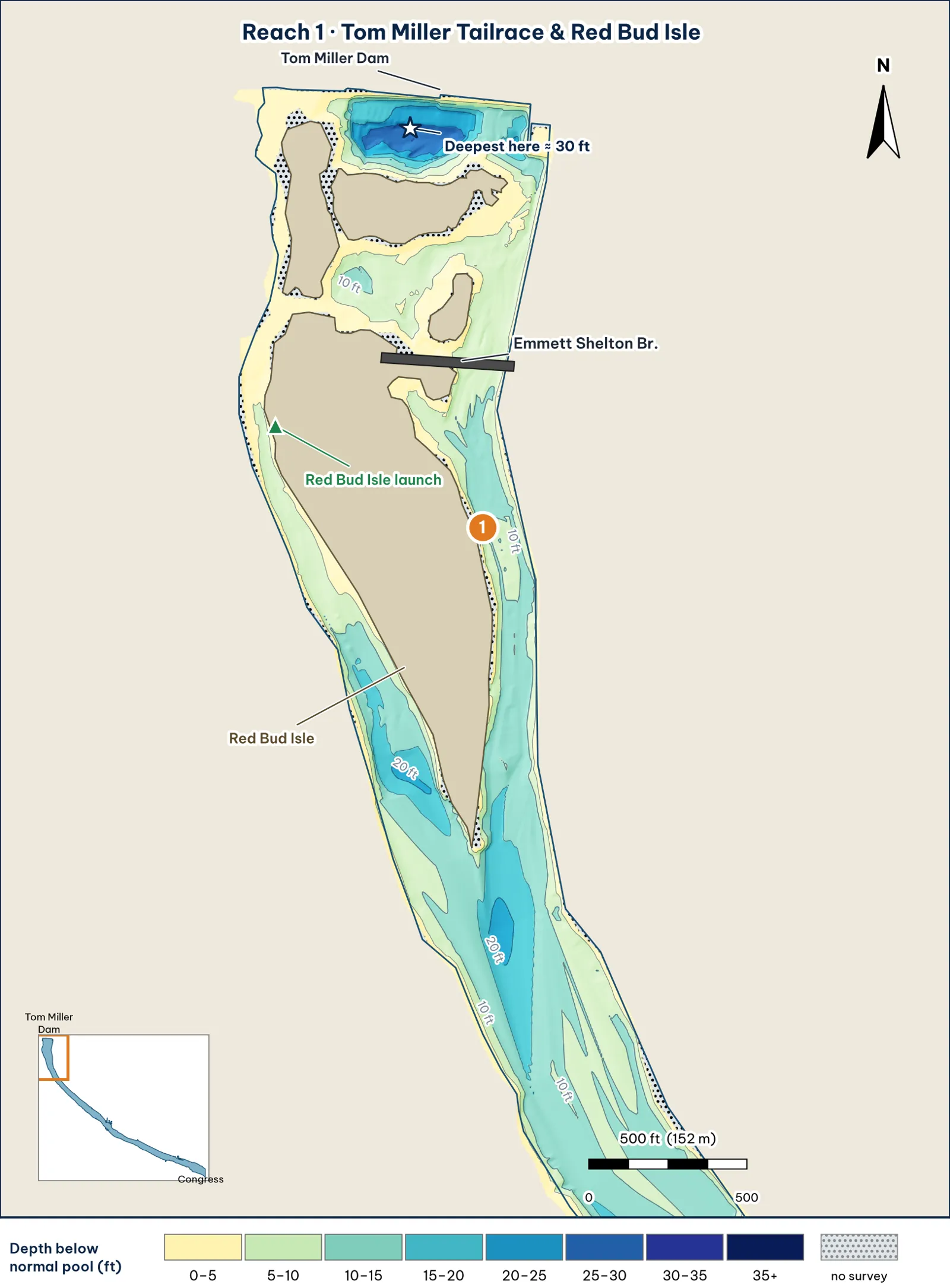
The Tom Miller tailrace and the channels around Red Bud Isle. Depth bands come from the TWDB 2008 grid, with OpenStreetMap shoreline and bridges. The star marks the deepest cell in the reach. Numbered markers are this guide's spots.
The bottom
- The tailrace scour hole. It's the deepest water in this guide. In the grid, the bottom falls past 20 ft over about 1.1 acres, a bowl roughly 500 ft across that starts about 50 ft below the dam face and runs to about 225 ft below it. It's past 25 ft over about half an acre, and bottoms out near 30–31 ft analysis. TWDB measured 2,376 soundings above the Emmett Shelton Bridge in 2008, so these depths are measured, not guessed. (In 1999, TWDB's boat couldn't get above that bridge, and LCRA supplied cross-sections for the area instead.) (TWDB 1999; TWDB 2008 shapefiles)
- Two channels around Red Bud Isle analysis:
- The west (right-bank) channel runs about 7–10 ft deep along the top half of the island. It deepens to about 16 ft at 2,000 ft below the dam and about 20 ft at 2,400 ft, toward the island's south tip.
- The east (left-bank) channel, the side with the Emmett Shelton Bridge, runs about 10–11 ft along the upper island and reaches about 15 ft at the tip.
- The two meet below the tip in a trough about 21 ft deep, roughly 2,800 ft below the dam.
- Back channels between the island's pieces are shallow, mostly under 5–10 ft.
- Banks. The banks drop off quickly, as you'd expect from TWDB's description of "a deep valley with steep-sided walls" (TWDB 1999). On the sample cross-section through the island, each channel bottoms out at about 11 ft within about 50–60 ft of the bank analysis.
Cover and grass
- Granite boulders. The City says the area holds "large granite boulder debris (from a previous catastrophic failure of the Austin Dam)" (City of Austin 2020). That's prime cover, and a sure snag.
- Grass. Fanwort grows "from Red Bud to I-35" (City of Austin, FY2024–25). The City's plant page also says Eurasian watermilfoil is "most dense in the upper reaches, where water temperatures are cooler," but TPWD's 2019 survey found milfoil absent since 2015. The two disagree unverified (City plant page; TPWD 2019).
- Bank cover. Giant reed "was most abundant near Red Bud Isle" (City plant page). Elsewhere, cover is mostly along the bank: "laydown logs and trees, overhanging brush, cypress tree roots" (TPWD).
- Bridge pilings. The Emmett Shelton Bridge has pilings across the east channel (OSM).
Water: clarity and current
- Clarity: the clearest water on the lake. The City says it's "very clear above Lamar" (City of Austin, FY2023).
- Where the water comes from. The City says the area is "almost exclusively influenced by Tom Miller Dam discharges from the hypolimnion of Lake Austin," meaning water drawn from deep in Lake Austin. It also warns of "unpredictable currents" (City of Austin 2020).
- Temperature swings less here. Long-term samples below the dam ranged from 52°F to 86°F. Downtown, they ranged from 41°F to 98°F (TXST 2019).
- Current hits this reach first and hardest. Releases arrive here before anywhere else, and they're strongest here analysis.
Through the seasons
| Season | What to expect | Play analysis |
|---|---|---|
| Spring | Clear water. A spring 2026 guide report had 4–6 ft visibility at about 68°F, with fish in submerged grass (Captain Experiences) | Slow-roll the inside channel edges and the back channels. Natural shad |
| Summer | The coolest water on the lake when the dam releases. Fanwort reaches the surface from July to September (City) | Dawn, and release windows. Work the edges of the scour hole and the Red Bud tip |
| Fall | Fanwort tops sit below the surface again from October on (City). Torwick found fish at about 73°F in mid-November 2024 | Grass edges along the channels, plus the tailrace when the dam releases. Swimbait while the water is above about 70°F |
| Winter | The narrowest temperature range on the lake. The 52°F low came in January 2011 (TXST) | Jig or big worm on the scour-hole edges. Long pauses |
How to fish it for a giant
The Approach
- Where a giant sits. The edge of the scour hole (about 31 ft at the bottom), the boulders against the dam, and the Emmett Shelton pilings. Hold over 12–15 ft on the edge and cast across the drop; don't park over the middle analysis.
- With current. Cast up-current and let a 6–7 in swimbait or a slow-sinking glide swing down past the rubble and pilings. Big bass hold behind boulders and wait for food to come to them inference.
- Without current. Drag a 3/4–1 oz football jig or a 10-in Texas-rigged worm down the hole's face from 15 to 25+ ft. Long pauses analysis.
- Glide control. Count the glide down at its sink rate (about 4–7 in per second for slow and super-slow models, per the glidebait report), so a 10-count puts it near 4–6 ft analysis.
- Line. 20–25 lb fluorocarbon for jigs and worms around rock and pilings; heavy glide gear (see the tackle chapter) analysis.
Access, hazards and rules
- Access. Red Bud Isle is a carry-in access on the TPWD paddling trail and a City park (TPWD paddling trail). There's no trailer ramp (TPWD access).
Hazard: current and algae
In 1964 the City counted 30 drownings over the previous decade, several of them caused by Tom Miller releases. The City warns of "unannounced swift current related to dam discharges" (City of Austin 2020). Wear your PFD.
Toxic blue-green algae mats have formed at Red Bud Isle, and six dog deaths in Austin have been linked to algae toxins since 2019. As of Oct 6, 2026, the algae was still present at Red Bud, though "much less" than earlier in the summer. 2026 is an untreated "control year" (City of Austin; City news). Keep dogs out of the water here and rinse your hands.
The Austin Rowing Club map marks "unmarked hazards (shallow)" near Red Bud (ARC map).
Rule
- Electric motors only, 5 hp or less, from 5 am to 10 pm (City code 8-5-82).
- No swimming or wading (City of Austin).
- The ARC map shows a loop traffic pattern around Red Bud Isle (ARC map).
Pro tip
Check LCRA's report before you go (see "Reading the Water"). If Tom Miller is scheduled to release this evening, be at the edge of the scour hole when the water starts moving. The guide reported bass holding tighter to structure when LCRA was releasing (Torwick). The timing is my inference inference.
Reach 1 Spots: Tom Miller Dam to Red Bud Isle
5 spots: 1A, 1B, 1C, 1D, 1E. Close-up maps from the 2008 survey; scores from the giant ranking.
1A · Tailrace scour-hole south lip
#1 of 51Deep water5Cover4Forage5Low pressure4Data4Best: Winter and pre-spawn · Post-spawn and summer
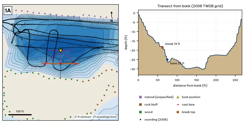
Orange line: break top. Blue dot: base of the break. Black dots: 2008 TWDB soundings. Shoreline squares: bank type (see the Bank-Type Map chapter). Contour interval: 2 ft, at 171 soundings per acre within 250 ft.
| Measure | Value |
|---|---|
| Depth at the bank | 1.1 ft (first wet grid cell, 0 ft from the OSM shoreline) analysis |
| Break top | 2.0 ft, 0 ft from the bank analysis |
| Base of the break | 24.4 ft, 78 ft from the bank analysis |
| Slope | steepest 4.3 ft per 10 ft; average 2.9 ft per 10 ft across the break analysis |
| Bank type | wood (confidence: low-medium) |
| Deep-water access | 20-ft water 65 ft away; 25-ft water 75 ft away; deepest within 300 ft: 30 ft analysis |
| Data support | fair (nearest sounding 34 ft from the break) |
Why a giant would use it. The tailrace scour hole is the deepest water in the guide (about 25–31 ft). When Tom Miller generates, this is where current is strongest and baitfish get pushed and disoriented; the south lip is the first slack-to-current edge downstream of the turbines. Score factors: cover = riprap and scour hole; forage = turbine-washed shad and sunfish; pressure = boat-only water under the dam. inference
Wind and current. Best wind: from the N (blowing onto this bank) analysis. Wind matters less than current here; the dam and bluffs shelter the hole (see the fetch table). Generation ON is the bite trigger here. Hold on the lip and let the current sweep the bait over the edge. With no release, fish the lip slowly. inference
Sun and shade today (Oct 12). This is the W bank of the reach. With 40-ft trees, a shade band of 25 ft or more falls on the water at: 4:00 pm, 5:00 pm, 6:00 pm, 6:30 pm. analysis
Boat position and cast lanes. Hold over about 26 ft, roughly 122 ft off the bank (yellow triangle). Fan three casts to the break top (magenta arrows), then turn and work parallel to the break along the dashed lane inference.
Big-bass plan by season (★ = this spot is a seasonal pick) inference
- ★ Winter / pre-spawn: 3/4–1 oz football jig or 10-in Texas-rigged worm dragged down the face from 2 to 24 ft, then on into the 30-ft water. Long pauses.
- Spawn: Slow-sinking glide counted down to the break top (2 ft), swum along it and killed at the edge.
- ★ Summer: Walking topwater or wake bait along the bank in the first and last hour; a 10–12 in worm on the 24-ft base in between.
- Fall: Swimbait or glide run parallel to the break top as shad push up.
1B · Emmett Shelton Bridge piling row
#19 of 51Deep water1Cover4Forage4Low pressure4Data5Best: Fall
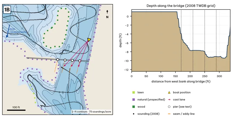
The bridge line is the OSM road or rail centerline. Pier markers are inferred from NBI span counts by assuming equal spans centered on the channel, except at the railroad bridge, where TWDB's footing outlines are used. Orange dashes show where a downstream eddy line should form during a release inference. Contours: 2-ft, at 75 soundings per acre within 250 ft.
| Measure | Value |
|---|---|
| Bridge (NBI 2025) | 10 spans, 121.9 m (400 ft) long, longest span 12.2 m (40 ft), built 1948; a separate 3-span relief bridge crosses the west channel |
| Water width along the deck | 339 ft (2008 TWDB shoreline) analysis |
| Deepest water under the deck | 9.4 ft, 312 ft from the west end analysis |
| Deep-water access | deepest within 300 ft: 12 ft analysis |
| Data support | 75 soundings per acre; nearest sounding 26 ft from the crossing center |
Why a giant would use it. Pilings are the only hard vertical cover in the main east channel of Reach 1. During releases each pier makes a small eddy on its downstream side, which is where a bass can sit out of the current and still see bait wash by. Score factors: cover = bridge pilings; forage = current carries bait past piers; pressure = boat-only, upper lake. inference
Wind and current. With a release on, work from upstream and drift baits past the downstream face of each pier. Slack water: fish them like any vertical post. Wind is minor here; the channel is narrow (S fetch median ~580 ft). A north wind blows straight down the channel and adds to the current. inference
Sun and shade today (Oct 12). Shade under the deck at all hours. analysis
Boat position and cast lanes. Hold upstream of the deepest span (yellow triangle) and cast down-current to the eddy behind each pier (magenta arrows) inference.
Big-bass plan by season (★ = this spot is a seasonal pick) inference
- Winter / pre-spawn: 3/4 oz football jig or a 10-in Texas-rigged worm crawled along the pier bases in the deepest span (about 9 ft). Pause 5–10 seconds at each pier.
- Spawn: 6–8 in slow-sinking glide (sunfish or shad colors) swum past the shady side of each pier and killed beside it. Give followers the 180° turn.
- Summer: The deck shades the piers all day. Pitch a 3/4 oz jig or a 10-in worm to the pier bases at first light and from dusk to the 10 pm fishing cutoff.
- ★ Fall: 6–7 in swimbait or soft glide down the current seam past each pier when Tom Miller is releasing.
Hazard · Bridge debris Broken concrete and rebar lie under the bridges (City of Austin 2025). Expect snags.
1C · Rock bank below the dam (east side)
#6 of 51Deep water4Cover4Forage4Low pressure4Data4Best: any season (not a seasonal pick)
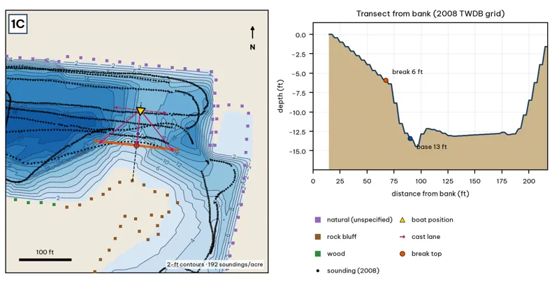
Orange line: break top. Blue dot: base of the break. Black dots: 2008 TWDB soundings. Shoreline squares: bank type (see the Bank-Type Map chapter). Contour interval: 2 ft, at 192 soundings per acre within 250 ft.
| Measure | Value |
|---|---|
| Depth at the bank | 0.0 ft (first wet grid cell, 15 ft from the OSM shoreline) analysis |
| Break top | 2.9 ft, 42 ft from the bank analysis |
| Base of the break | 12.6 ft, 88 ft from the bank analysis |
| Slope | steepest 3.4 ft per 10 ft; average 2.2 ft per 10 ft across the break analysis |
| Bank type | rock bluff (confidence: low-medium) |
| Deep-water access | 20-ft water 100 ft away; 25-ft water 108 ft away; deepest within 300 ft: 30 ft analysis |
| Data support | fair (nearest sounding 32 ft from the break) |
Why a giant would use it. Rock bluff meets the scour-hole slope. Rock holds heat and crawfish, and the bank turns to channel within about 90 ft. Score factors: cover = rock bluff; forage = crawfish on rock; shad below dam; pressure = boat-only. inference
Wind and current. Best wind: from the N (blowing onto this bank) analysis. A north wind blows onto this bank, but the fetch is short. Releases push water along this bank; fish the downstream end of the rock where the current slackens. inference
Sun and shade today (Oct 12). This is the W bank of the reach. With 40-ft trees, a shade band of 25 ft or more falls on the water at: 4:00 pm, 5:00 pm, 6:00 pm, 6:30 pm. analysis
Boat position and cast lanes. Hold over about 14 ft, roughly 132 ft off the bank (yellow triangle). Fan three casts to the break top (magenta arrows), then turn and work parallel to the break along the dashed lane inference.
Big-bass plan by season (★ = this spot is a seasonal pick) inference
- Winter / pre-spawn: 3/4–1 oz football jig or 10-in Texas-rigged worm dragged down the face from 3 to 13 ft, then on into the 30-ft water. Long pauses.
- Spawn: Slow-sinking glide counted down to the break top (3 ft), swum along it and killed at the edge.
- Summer: Walking topwater or wake bait along the bank in the first and last hour; a 10–12 in worm on the 13-ft base in between.
- Fall: Swimbait or glide run parallel to the break top as shad push up.
1D · West channel outside bank
#38 of 51Deep water1Cover3Forage3Low pressure4Data4Best: any season (not a seasonal pick)
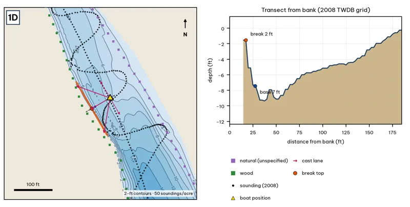
Orange line: break top. Blue dot: base of the break. Black dots: 2008 TWDB soundings. Shoreline squares: bank type (see the Bank-Type Map chapter). Contour interval: 2 ft, at 50 soundings per acre within 250 ft.
| Measure | Value |
|---|---|
| Depth at the bank | 1.5 ft (first wet grid cell, 15 ft from the OSM shoreline) analysis |
| Break top | 3.0 ft, 15 ft from the bank analysis |
| Base of the break | 8.1 ft, 32 ft from the bank analysis |
| Slope | steepest 3.5 ft per 10 ft; average 2.9 ft per 10 ft across the break analysis |
| Bank type | wood (confidence: low-medium) |
| Deep-water access | 20-ft water 555 ft away; 25-ft water 1470 ft away; deepest within 300 ft: 17 ft analysis |
| Data support | fair (nearest sounding 34 ft from the break) |
Why a giant would use it. The outside bank of the west channel. The current hugs it, keeping a 5–9 ft trough tight to a wooded bank. Score factors: cover = wooded outside bank; forage = sunfish on wood; pressure = boat-only. inference
Wind and current. Best wind: from the ENE (blowing onto this bank) analysis. ENE wind blows onto it (rare); most of the time it is sheltered. Strongest during releases (west channel takes part of the flow). Start upstream and work down the bank. inference
Sun and shade today (Oct 12). This is the W bank of the reach. With 40-ft trees, a shade band of 25 ft or more falls on the water at: 4:00 pm, 5:00 pm, 6:00 pm, 6:30 pm. analysis
Boat position and cast lanes. Hold over about 9 ft, roughly 78 ft off the bank (yellow triangle). Fan three casts to the break top (magenta arrows), then turn and work parallel to the break along the dashed lane inference.
Big-bass plan by season (★ = this spot is a seasonal pick) inference
- Winter / pre-spawn: 3/4–1 oz football jig or 10-in Texas-rigged worm dragged down the face from 3 to 8 ft, then on into the 17-ft water. Long pauses.
- Spawn: Slow-sinking glide counted down to the break top (3 ft), swum along it and killed at the edge.
- Summer: Walking topwater or wake bait along the bank in the first and last hour; a 10–12 in worm on the 8-ft base in between.
- Fall: Swimbait or glide run parallel to the break top as shad push up.
1E · Red Bud Isle south tip and channel merge
#29 of 51Deep water2Cover3Forage4Low pressure2Data4Best: Fall
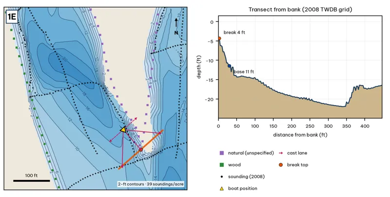
Orange line: break top. Blue dot: base of the break. Black dots: 2008 TWDB soundings. Shoreline squares: bank type (see the Bank-Type Map chapter). Contour interval: 2 ft, at 39 soundings per acre within 250 ft.
| Measure | Value |
|---|---|
| Depth at the bank | 4.6 ft (first wet grid cell, 0 ft from the OSM shoreline) analysis |
| Break top | 5.1 ft, 0 ft from the bank analysis |
| Base of the break | 13.1 ft, 42 ft from the bank analysis |
| Slope | steepest 2.8 ft per 10 ft; average 1.9 ft per 10 ft across the break analysis |
| Bank type | natural (confidence: low) |
| Deep-water access | 20-ft water 181 ft away; 25-ft water 2192 ft away; deepest within 300 ft: 22 ft analysis |
| Data support | fair (nearest sounding 21 ft from the break) |
Why a giant would use it. The island tip where the two channels merge. Current seams form off the tip, and the merge trough drops to about 21 ft downstream. Score factors: cover = island tip, laydowns; forage = seam concentrates bait; pressure = Red Bud Isle bank anglers. inference
Wind and current. Best wind: from the NW (blowing onto this bank) analysis. A NW wind blows across the tip; the fetch is short. Releases make a clear seam off the tip; the down-current eddy is the target. inference
Sun and shade today (Oct 12). This is the E bank of the reach. With 40-ft trees, a shade band of 25 ft or more falls on the water at: 8:05 am, 9:00 am, 10:00 am, 11:00 am. analysis
Boat position and cast lanes. Hold over about 15 ft, roughly 88 ft off the bank (yellow triangle). Fan three casts to the break top (magenta arrows), then turn and work parallel to the break along the dashed lane inference.
Big-bass plan by season (★ = this spot is a seasonal pick) inference
- Winter / pre-spawn: 3/4–1 oz football jig or 10-in Texas-rigged worm dragged down the face from 5 to 13 ft, then on into the 22-ft water. Long pauses.
- Spawn: Slow-sinking glide counted down to the break top (5 ft), swum along it and killed at the edge.
- Summer: Walking topwater or wake bait along the bank in the first and last hour; a 10–12 in worm on the 13-ft base in between.
- ★ Fall: Swimbait or glide run parallel to the break top as shad push up.