The Giant Spots, Ranked
Every one of the 51 spots gets a giant-potential score out of 100. It is my judgment of where an 8-lb-plus bass is most likely to live and feed, built from five factors, each scored 1–5 analysisinference:
- Deep water (counts double). How close the spot is to 20- and 25-ft water, and the deepest water within 300 ft, measured from the 2008 grid analysis. Big bass in a shallow river lake need a deep retreat close to their feeding area inference.
- Cover. Bridge piers, rock, wood, docks and depth changes at the spot inference.
- Forage. Creek mouths, current seams and sunfish banks inference.
- Low pressure. How few anglers and paddlers I expect, a judgment call unverified.
- Data. How many real soundings support the depth picture at the spot analysis.
Score = (2 × deep + cover + forage + pressure + data) ÷ 30 × 100. Ties share the same score and are ranked in guide order analysis.
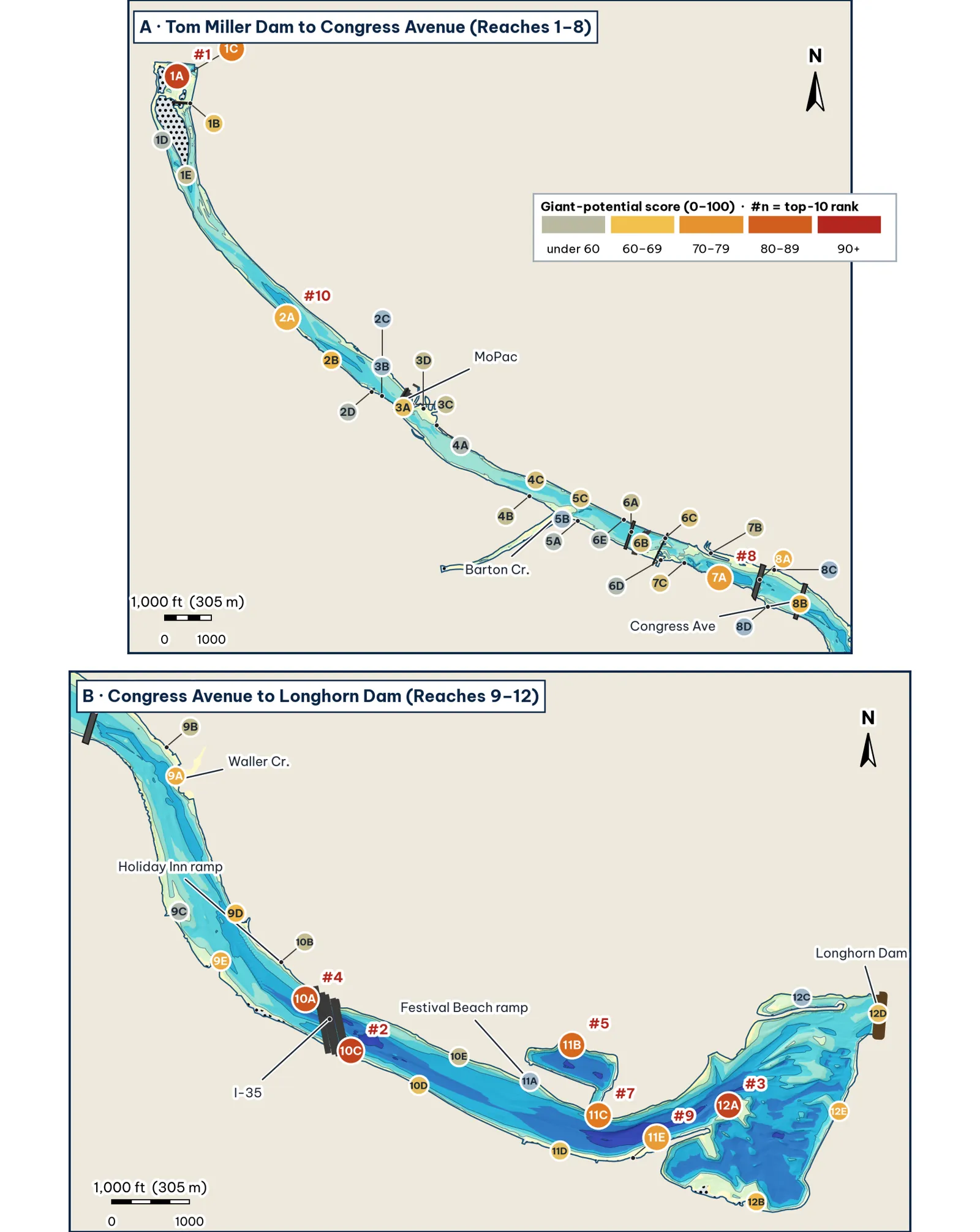
Spots colored by giant score. Labels show rank and spot ID analysis.
The top five, and why
#1 · 1A Tailrace scour-hole south lip · 90/100. The 30-ft scour hole below Tom Miller Dam is the deepest water on the upper lake, right against boulders and the dam's rubble, in the clearest water on the lake. Releases carry food through it analysisinference. Best seasons: Winter and pre-spawn (Dec–Feb), Post-spawn and summer (May–Aug). Deep water: 25-ft water 75 ft away; 30 ft within 300 ft analysis. See spot 1A.
#2 · 10C Harpers Branch mouth into the 33-ft hole · 90/100. Harpers Branch enters right beside a 33-ft hole, so a feeding flat and a deep retreat sit within one long cast (25-ft water about 60 ft away). It is in the lower lake, which most bass anglers skip analysisinference. Best seasons: Winter and pre-spawn (Dec–Feb), Fall (Sep–Nov). Deep water: 25-ft water 60 ft away; 33 ft within 300 ft analysis. See spot 10C.
#3 · 12A Snake Island west tip and the 30-ft channel · 90/100. The west tip of Snake Island splits the current at the head of the lower basin, with a 30-ft channel about 60 ft off the tip. Island points, current, deep water and light pressure all stack here analysisinference. Best seasons: Winter and pre-spawn (Dec–Feb), Fall (Sep–Nov). Deep water: 25-ft water 61 ft away; 31 ft within 300 ft analysis. See spot 12A.
#4 · 10A I-35 piling rows (main and frontage bridges) · 87/100. Three parallel I-35 bridges put the deepest pier water on the lake (about 30 ft under the main span) in permanent shade. Construction keeps most anglers away analysisinference. Best seasons: Winter and pre-spawn (Dec–Feb), Post-spawn and summer (May–Aug). Deep water: 25-ft water right at the spot; 31 ft within 300 ft analysis. See spot 10A.
#5 · 11B Fiesta Gardens lagoon 30-ft hole · 83/100. A boat-sized lagoon off the main lake whose north wall drops from about 3 ft to 24 ft within 48 ft, into a 30-ft hole. It is the kind of calm, deep pocket where big fish winter and stage before spawning analysisinference. Best seasons: Winter and pre-spawn (Dec–Feb), Spawn (Mar–Apr). Deep water: 25-ft water 56 ft away; 30 ft within 300 ft analysis. See spot 11B.
All 51 spots
| # | Spot | Score | Deep | Cover | Forage | Press. | Data | 25 ft at | Seasons |
|---|---|---|---|---|---|---|---|---|---|
| 1 | 1A Tailrace scour-hole south lip | 90 | 5 | 4 | 5 | 4 | 4 | 75 ft | W Su |
| 2 | 10C Harpers Branch mouth into the 33-ft hole | 90 | 5 | 3 | 5 | 4 | 5 | 60 ft | W F |
| 3 | 12A Snake Island west tip and the 30-ft channel | 90 | 5 | 4 | 4 | 4 | 5 | 61 ft | W F |
| 4 | 10A I-35 piling rows (main and frontage bridges) | 87 | 5 | 5 | 4 | 3 | 4 | <10 ft | W Su |
| 5 | 11B Fiesta Gardens lagoon 30-ft hole | 83 | 5 | 3 | 4 | 4 | 4 | 56 ft | W Sp |
| 6 | 1C Rock bank below the dam (east side) | 80 | 4 | 4 | 4 | 4 | 4 | 108 ft | – |
| 7 | 11C Holly pier to the 35-ft hole (deepest water in the lake) | 80 | 5 | 4 | 4 | 2 | 4 | 64 ft | W |
| 8 | 7A South wall at the 27-ft hole | 73 | 5 | 3 | 3 | 2 | 4 | 40 ft | W |
| 9 | 11E Peace Point dock drop (south bank) | 73 | 4 | 3 | 3 | 3 | 5 | 123 ft | Su |
| 10 | 2A South-bank rock bluff | 70 | 3 | 4 | 3 | 4 | 4 | none near | W |
| 11 | 8A South 1st Street Bridge piling row | 70 | 3 | 4 | 4 | 2 | 5 | 560 ft | Su |
| 12 | 9A Waller Creek mouth into the channel | 70 | 3 | 3 | 5 | 2 | 5 | 2,786 ft | Sp F |
| 13 | 9E Blunn Creek delta lip | 70 | 3 | 3 | 4 | 3 | 5 | 529 ft | Sp |
| 14 | 12E Longhorn Shores bank drop (east bank) | 70 | 3 | 3 | 3 | 5 | 4 | 225 ft | – |
| 15 | 2B The 24-ft trough | 67 | 3 | 3 | 3 | 4 | 4 | none near | – |
| 16 | 8B Congress Avenue Bridge piling row | 67 | 3 | 4 | 4 | 2 | 4 | 1,515 ft | Su |
| 17 | 9D Community Dock north-bank drop | 67 | 3 | 4 | 3 | 3 | 4 | 864 ft | Su |
| 18 | 12B Lakeshore Park south lobe drop | 67 | 2 | 3 | 4 | 5 | 4 | 191 ft | Sp |
| 19 | 1B Emmett Shelton Bridge piling row | 63 | 1 | 4 | 4 | 4 | 5 | 694 ft | F |
| 20 | 3A MoPac piling rows | 63 | 2 | 4 | 4 | 3 | 4 | none near | Su |
| 21 | 10D South-bank boardwalk drop | 63 | 4 | 3 | 3 | 3 | 2 | 116 ft | – |
| 22 | 11D International Shores pier drop (south bank) | 63 | 4 | 4 | 3 | 3 | 1 | 109 ft | Su |
| 23 | 12D Longhorn Dam face | 63 | 2 | 4 | 3 | 4 | 4 | 644 ft | F |
| 24 | 4C North-bank drop into the 19-ft pocket | 60 | 2 | 3 | 3 | 3 | 5 | none near | – |
| 25 | 5C North wall into the 22-ft hole | 60 | 3 | 3 | 3 | 2 | 4 | none near | F |
| 26 | 6B Pfluger Bridge piling row | 60 | 3 | 3 | 3 | 2 | 4 | 1,746 ft | – |
| 27 | 6C Railroad bridge and islands | 60 | 2 | 4 | 3 | 2 | 5 | 1,334 ft | – |
| 28 | 7C South bank below the railroad bridge | 60 | 3 | 2 | 3 | 2 | 5 | 742 ft | – |
| 29 | 1E Red Bud Isle south tip and channel merge | 57 | 2 | 3 | 4 | 2 | 4 | 2,192 ft | F |
| 30 | 3C North flat below MoPac | 57 | 2 | 2 | 3 | 3 | 5 | none near | – |
| 31 | 3D Johnson Branch delta flat | 57 | 1 | 3 | 4 | 3 | 5 | none near | Sp |
| 32 | 4B South bank wood line, Zilker | 57 | 2 | 3 | 3 | 3 | 4 | none near | – |
| 33 | 6A Lamar Blvd Bridge piling row | 57 | 2 | 4 | 4 | 2 | 3 | 2,039 ft | Su |
| 34 | 7B Shoal Creek delta lip | 57 | 2 | 3 | 4 | 2 | 4 | 455 ft | Sp |
| 35 | 9B Waller Creek boathouse docks (north bank) | 57 | 2 | 4 | 3 | 2 | 4 | 2,527 ft | Su |
| 36 | 10B Holiday Inn ramp drop (north bank) | 57 | 2 | 3 | 3 | 3 | 4 | 340 ft | – |
| 37 | 10E North-bank pier shelf above Festival Beach | 57 | 3 | 3 | 3 | 3 | 2 | 306 ft | – |
| 38 | 1D West channel outside bank | 53 | 1 | 3 | 3 | 4 | 4 | 1,470 ft | – |
| 39 | 2D Eanes Creek mouth | 53 | 2 | 3 | 4 | 3 | 2 | none near | Sp |
| 40 | 4A Texas Rowing Center north bank | 53 | 2 | 3 | 3 | 2 | 4 | none near | – |
| 41 | 5A Barton flat lip | 53 | 2 | 2 | 4 | 2 | 4 | none near | – |
| 42 | 6D West Bouldin Creek mouth and south shelf | 53 | 1 | 3 | 4 | 2 | 5 | 1,239 ft | F |
| 43 | 6E North channel wall at Lamar | 53 | 2 | 3 | 3 | 2 | 4 | 2,298 ft | – |
| 44 | 9C East Bouldin mouth and the islet | 53 | 1 | 3 | 4 | 3 | 4 | 1,318 ft | Sp |
| 45 | 3B South channel wall above MoPac | 50 | 2 | 3 | 3 | 3 | 2 | none near | – |
| 46 | 5B Barton Creek mouth delta | 50 | 1 | 3 | 5 | 1 | 4 | none near | Sp |
| 47 | 8C North-bank reed shelf between the bridges | 50 | 1 | 3 | 3 | 2 | 5 | 892 ft | – |
| 48 | 11A Festival Beach ramp point | 50 | 3 | 3 | 3 | 1 | 2 | 302 ft | – |
| 49 | 12C North arm flat edge (Metz side) | 50 | 1 | 2 | 3 | 4 | 4 | 825 ft | Sp |
| 50 | 2C Deep Eddy / Eilers Park north shelf | 47 | 1 | 2 | 3 | 3 | 4 | none near | – |
| 51 | 8D South-shore piers below 1st St | 47 | 1 | 4 | 3 | 2 | 3 | 937 ft | – |
Factor scores 1–5. "25 ft at": distance to the nearest 25-ft water in the 2008 grid; "none near" means more than 3,000 ft. Seasons: W winter/pre-spawn, Sp spawn, Su summer, F fall analysis.