The Whole Lake
What kind of water this is
Lady Bird Lake is the Colorado River held at one level between two dams. TWDB calls it a "constant level riverine lake," run as a "pass through" reservoir (TWDB 1999). The level is "Stable," per TPWD. When Tom Miller Dam releases water, the lake doesn't rise; the water just starts to move. The lake covers about 470 acres (TWDB 2008) and runs 6.0 river miles along the centerline from Tom Miller Dam to Longhorn Dam analysis.
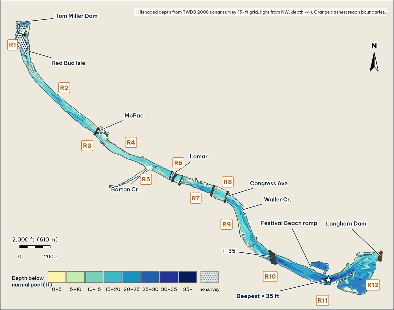
The whole lake, hillshaded from my 5-ft grid of TWDB's 2008 survey points analysis. Reach numbers and boundaries are shown; the lower lake (Reaches 9–12) is wider and deeper than the upper river. A full-page fold-out version follows this chapter.
Five things that matter for big bass
- The deepest water is in the lower lake, not at the dam. The deepest cell on the whole lake is about 35 ft at the Holly bend (Reach 11), and the lower basin above Longhorn Dam reaches about 31 ft analysis. The upper lake's deepest spot is the 30-ft tailrace scour below Tom Miller. TPWD's lake page lists an 18-ft maximum depth (TPWD); TWDB's 2008 soundings show much deeper water analysis.
- The face of Longhorn Dam is not the deep spot. The water against the dam is only about 15–21 ft deep in the grid analysis. The deep water sits a half-mile upstream.
- Giants come from the clear upper lake too. The lake record (14.05 lb) was a bedding fish sight-fished on the Barton Creek shoreline in February (Outdoor Life).
- There is very little grass. TPWD's 2019 survey found native plants on about 0.8% of the lake, mostly water willow and bulrush (TPWD 2019). Cover means wood, rock, docks, bridge piers and depth changes.
- Sunfish are the main menu. Redbreast sunfish dominated TPWD's 2019 forage sample (217 an hour), ahead of gizzard shad (50 an hour) (same source). Big baits in sunfish colors make sense analysis.
The twelve reaches
| Reach | River miles | Deepest analysis | Typical width analysis | Character |
|---|---|---|---|---|
| R1 Dam–Red Bud | 0.0–0.6 | 30 ft | 180 ft per channel | Tailrace scour, two channels around Red Bud Isle |
| R2 Red Bud–MoPac | 0.6–1.6 | 24 ft | 445 ft | Narrow, steep, cypress banks |
| R3 MoPac | 1.6–1.9 | 20 ft | 470 ft | Bridge pilings, north flat |
| R4 Austin High–Zilker | 1.9–2.4 | 18 ft | 380 ft | Shallow, uniform |
| R5 Barton mouth | 2.4–2.7 | 22 ft | 470 ft | Spring-fed creek and flat |
| R6 Lamar–RR bridge | 2.7–3.0 | 20 ft | 515 ft | Three bridges |
| R7 Shoal–1st St | 3.0–3.4 | 27 ft | 430 ft | 27-ft hole, steep south wall |
| R8 1st St–Congress | 3.4–3.6 | 21 ft | 720 ft | Downtown piers |
| R9 Congress–Blunn | 3.6–4.3 | 24 ft | 615 ft | Waller and Blunn creeks |
| R10 Blunn–Festival Beach | 4.3–5.0 | 33 ft | 585 ft | I-35 piers, Harpers Branch hole |
| R11 Festival–Holly | 5.0–5.5 | 35 ft | 620 ft | Lagoon, deepest water on the lake |
| R12 Lower basin | 5.5–6.0 | 31 ft | 1,280 ft | Snake Island, Longhorn Dam |
Widths are medians of cross-sections every 50 ft; deepest is the deepest grid cell in each reach analysis.
About the depth data
TWDB publishes its 2008 survey as 24,647 measured soundings plus interpolated points (TWDB 2008 shapefiles). Every map, profile and 3-D view here comes from a 5-ft grid I built by straight-line triangulation between those points analysis. TWDB warns its maps are "not intended for use as recreational boating maps, fishing maps." Depth is measured from a 429-ft pool; the bottom may have changed since 2008 (TWDB 2008).
The upper river in profile (Reaches 1–8)
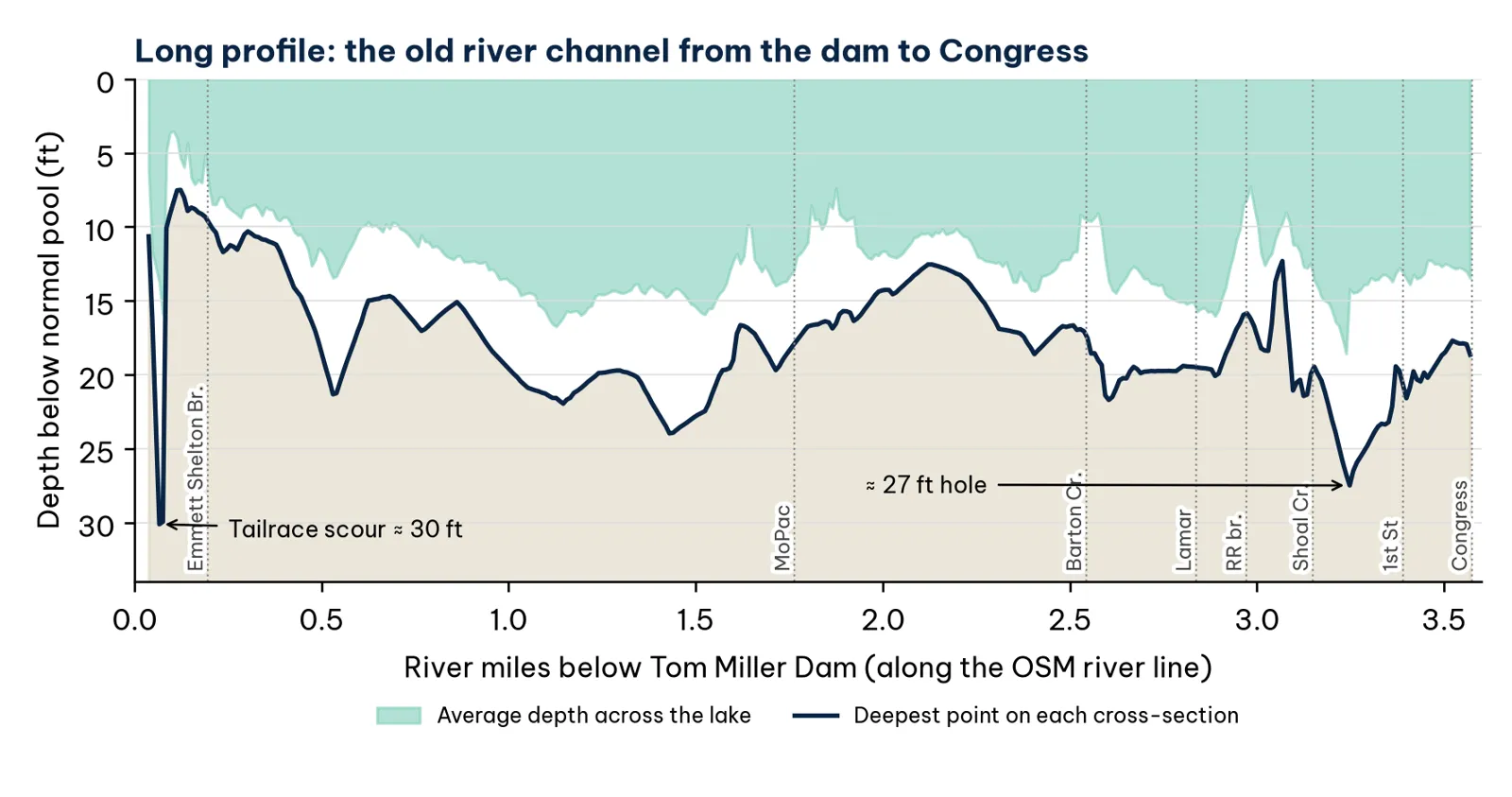
Deepest and average depth every 50 ft along the river from Tom Miller Dam to Congress, carried over from v2 analysis. East of Congress, the reach maps and the deep-water figures on each spot page show the lower lake.
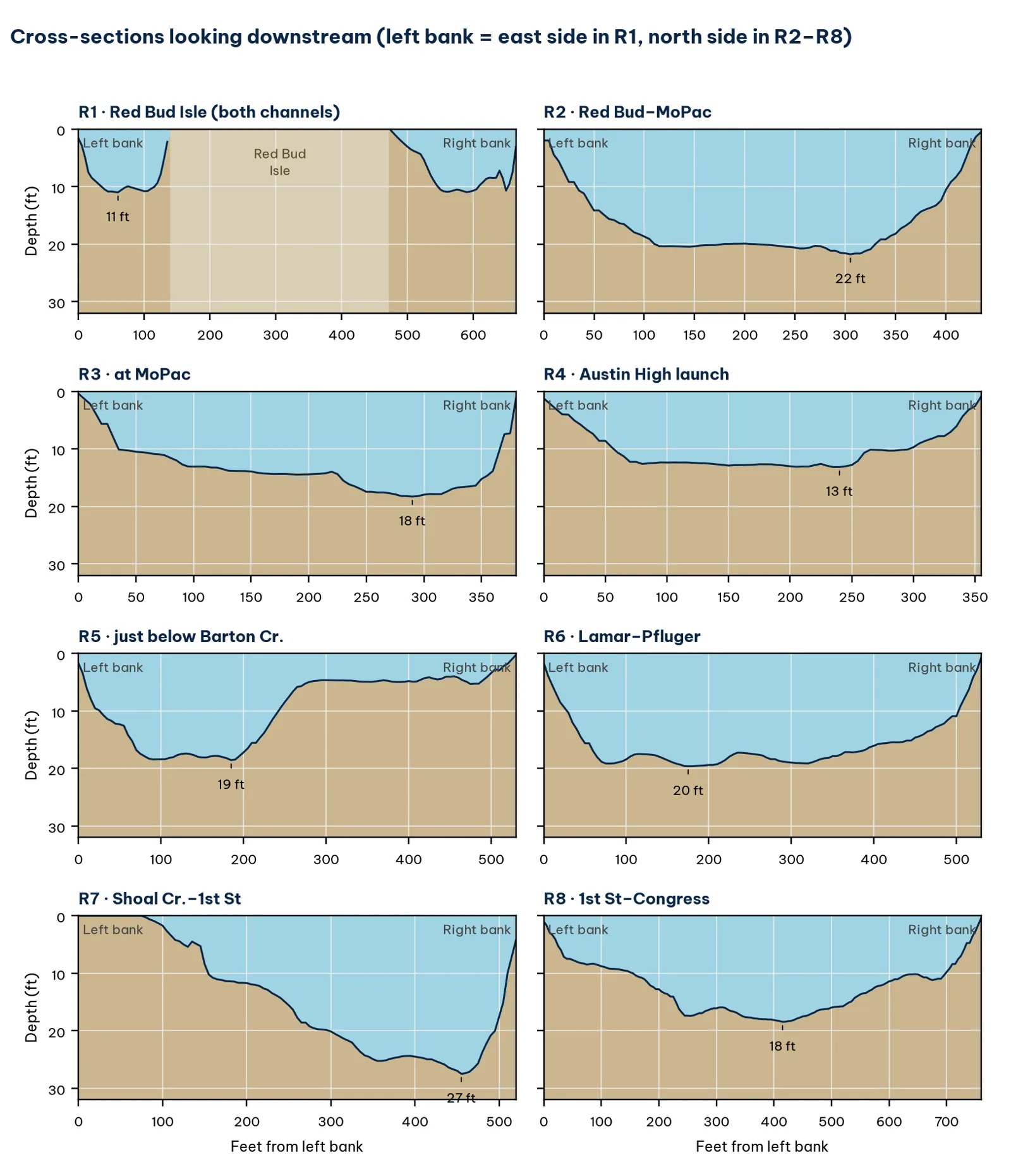
One sample cross-section per upper reach, looking downstream analysis. They show which bank drops fast and which one is a long shelf.