Reach 10 · Blunn Creek to Festival Beach
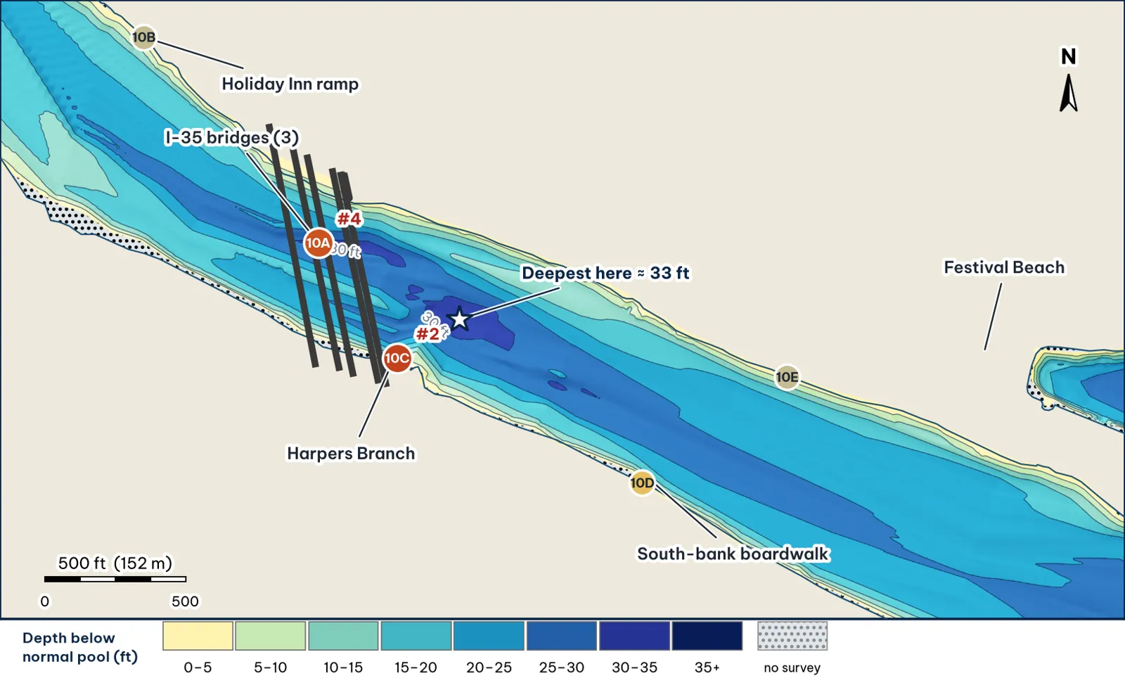
Blunn Creek to Festival Beach, through the three I-35 bridges and past Harpers Branch. Depths from my grid of TWDB 2008 points analysis.
The bottom analysis
- The lake gets deep here. The median deepest point of each cross-section is about 28 ft, and the deepest cell is about 33 ft, next to Harpers Branch (10C).
- I-35 crosses deep water. About 30 ft under the main span (10A), the deepest piling water on the lake.
- Steep south bank. The boardwalk shore drops from about 4 ft to 18 ft within 52 ft, with 25-ft water within 120 ft (10D).
Cover and forage
- Bridge piers. Three I-35 structures: main lanes (9 spans, 1,052 ft, built 1954) and two frontage bridges (1982) (NBI via FHWA) analysis. I-35 is being rebuilt, so piers and access may change unverified.
- Creek inflow next to deep water at Harpers Branch (10C) and Blunn Creek just upstream analysis.
- Wooded north bank at the Holiday Inn ramp (10B) and above Festival Beach (10E) analysis.
Through the seasons inference
| Season | Giant play |
|---|---|
| Winter / pre-spawn | The best winter water on the lake. Football jig into the 33-ft hole at 10C; jig on the deepest I-35 piers |
| Spawn | Harpers Branch and Blunn Creek mouths; pre-spawn females stage on the 10D drop |
| Summer | I-35 shade all day: jig or 10-in worm on the pier bases at dawn and until 10 pm |
| Fall | Glide or swimbait across the Harpers Branch delta as shad move in |
How to fish it for a giant
The Approach
- 10C first. Sit in about 25 ft and work a jig from the creek delta down to the 28- and 33-ft water; a slow glide over the delta lip in low light analysis.
- I-35. Hold upstream of the deepest span and work each pier base; the deck keeps it shaded all day analysis.
- Line. 20–25 lb fluorocarbon around piers (Wired2Fish).
Access, hazards and rules
- Holiday Inn ramp: one lane, unimproved, west of I-35 (TPWD access).
I-35 construction
Expect barges, booms and temporary work platforms around I-35. Obey closures and keep clear of work crews unverified.
Reach 10 Spots: Blunn Creek to Festival Beach (I-35, Holiday Inn ramp)
5 spots: 10A, 10B, 10C, 10D, 10E. Close-up maps from the 2008 survey; scores from the giant ranking.
10A · I-35 piling rows (main and frontage bridges)
#4 of 51Deep water5Cover5Forage4Low pressure3Data4Best: Winter and pre-spawn · Post-spawn and summer
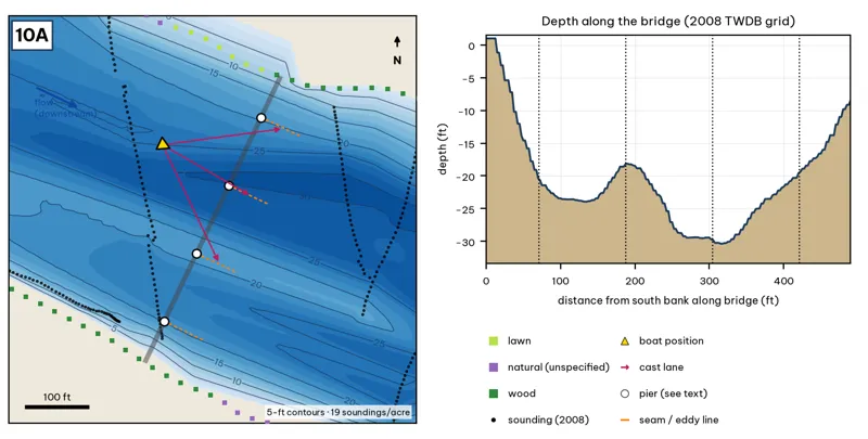
The bridge line is the OSM road or rail centerline. Pier markers are inferred from NBI span counts by assuming equal spans centered on the channel, except at the railroad bridge, where TWDB's footing outlines are used. Orange dashes show where a downstream eddy line should form during a release inference. Contours: 5-ft, at 19 soundings per acre within 250 ft.
| Measure | Value |
|---|---|
| Bridge (NBI 2025) | main lanes 9 spans, 1,052 ft, longest 130 ft, built 1954; two frontage bridges (1982). Being rebuilt |
| Water width along the deck | 492 ft (2008 TWDB shoreline) analysis |
| Deepest water under the deck | 30.4 ft, 318 ft from the south end analysis |
| Deep-water access | deepest within 300 ft: 31 ft analysis |
| Data support | 19 soundings per acre; nearest sounding 139 ft from the crossing center |
Why a giant would use it. Three parallel I-35 bridges with the deepest piling water in the lake: about 30 ft under the main span. Shade lines move across the water all day, and the piers break the slow river current. Score factors: cover = three I-35 bridges, deep piers; forage = shad in shade; pressure = construction zone, few anglers. inference
Wind and current. Weak current; fish the down-current side of each pier when Tom Miller releases. The bridges shelter the water underneath from most winds. Long SE and NW fetch along the reach. inference
Sun and shade today (Oct 12). Shade under the deck at all hours. analysis
Boat position and cast lanes. Hold upstream of the deepest span (yellow triangle) and cast down-current to the eddy behind each pier (magenta arrows) inference.
Big-bass plan by season (★ = this spot is a seasonal pick) inference
- ★ Winter / pre-spawn: 3/4 oz football jig or a 10-in Texas-rigged worm crawled along the pier bases in the deepest span (about 30 ft). Pause 5–10 seconds at each pier.
- Spawn: 6–8 in slow-sinking glide (sunfish or shad colors) swum past the shady side of each pier and killed beside it. Give followers the 180° turn.
- ★ Summer: The deck shades the piers all day. Pitch a 3/4 oz jig or a 10-in worm to the pier bases at first light and from dusk to the 10 pm fishing cutoff.
- Fall: 6–7 in swimbait or soft glide down the current seam past each pier when Tom Miller is releasing.
Hazard · Construction zone I-35 is being rebuilt; expect barges, booms and closures unverified.
10B · Holiday Inn ramp drop (north bank)
#36 of 51Deep water2Cover3Forage3Low pressure3Data4Best: any season (not a seasonal pick)
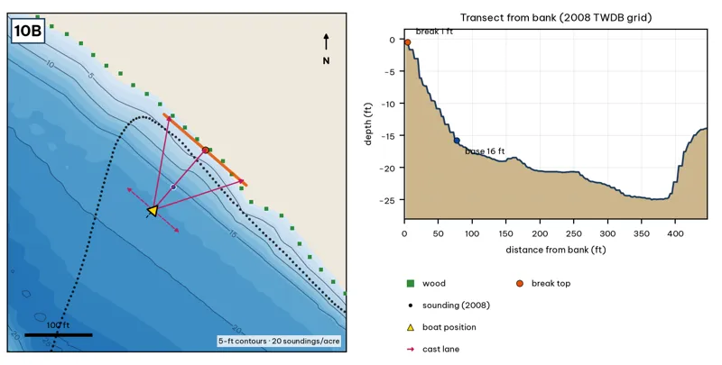
Orange line: break top. Blue dot: base of the break. Black dots: 2008 TWDB soundings. Shoreline squares: bank type (see the Bank-Type Map chapter). Contour interval: 5 ft, at 20 soundings per acre within 250 ft.
| Measure | Value |
|---|---|
| Depth at the bank | 0.5 ft (first wet grid cell, 2 ft from the OSM shoreline) analysis |
| Break top | 0.9 ft, 2 ft from the bank analysis |
| Base of the break | 16.3 ft, 82 ft from the bank analysis |
| Slope | steepest 2.9 ft per 10 ft; average 1.9 ft per 10 ft across the break analysis |
| Bank type | wood (confidence: low-medium) |
| Deep-water access | 20-ft water 183 ft away; 25-ft water 340 ft away; deepest within 300 ft: 23 ft analysis |
| Data support | fair (nearest sounding 22 ft from the break) |
Why a giant would use it. The Holiday Inn ramp sits on a wooded north bank that slopes to about 16 ft 80 ft out, with 25-ft water within 340 ft. Score factors: cover = ramp, wooded bank; forage = sunfish; pressure = small ramp. inference
Wind and current. Best wind: from the SW (blowing onto this bank) analysis. SW wind blows onto it. Slight current. inference
Sun and shade today (Oct 12). This is the NE bank of the reach. With 40-ft trees, a shade band of 25 ft or more falls on the water at: 8:05 am. analysis
Boat position and cast lanes. Hold over about 18 ft, roughly 128 ft off the bank (yellow triangle). Fan three casts to the break top (magenta arrows), then turn and work parallel to the break along the dashed lane inference.
Big-bass plan by season (★ = this spot is a seasonal pick) inference
- Winter / pre-spawn: 3/4–1 oz football jig or 10-in Texas-rigged worm dragged down the face from 1 to 16 ft, then on into the 23-ft water. Long pauses.
- Spawn: Slow-sinking glide counted down to the break top (1 ft), swum along it and killed at the edge.
- Summer: Walking topwater or wake bait along the bank in the first and last hour; a 10–12 in worm on the 16-ft base in between.
- Fall: Swimbait or glide run parallel to the break top as shad push up.
10C · Harpers Branch mouth into the 33-ft hole
#2 of 51Deep water5Cover3Forage5Low pressure4Data5Best: Winter and pre-spawn · Fall
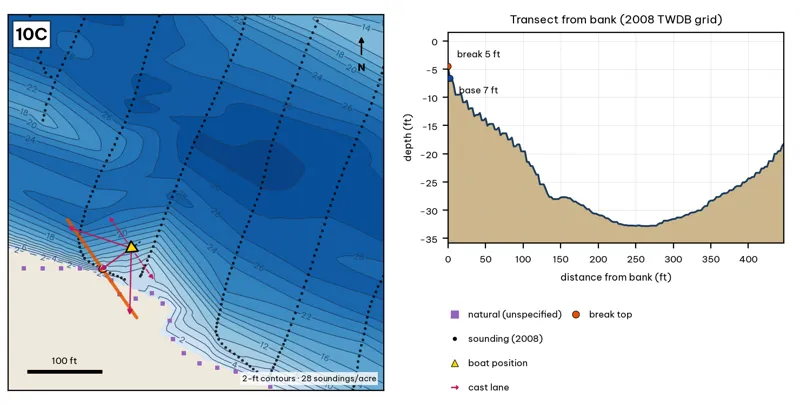
Orange line: break top. Blue dot: base of the break. Black dots: 2008 TWDB soundings. Shoreline squares: bank type (see the Bank-Type Map chapter). Contour interval: 2 ft, at 28 soundings per acre within 250 ft.
| Measure | Value |
|---|---|
| Depth at the bank | 4.5 ft (first wet grid cell, 0 ft from the OSM shoreline) analysis |
| Break top | 5.9 ft, 0 ft from the bank analysis |
| Base of the break | 13.5 ft, 42 ft from the bank analysis |
| Slope | steepest 2.8 ft per 10 ft; average 1.8 ft per 10 ft across the break analysis |
| Bank type | natural (confidence: low) |
| Deep-water access | 20-ft water 45 ft away; 25-ft water 60 ft away; deepest within 300 ft: 33 ft analysis |
| Data support | good (a 2008 sounding lies within 15 ft of the break) |
Why a giant would use it. Harpers Branch enters right next to the deepest bridge water: the transect falls from about 6 ft at the bank to 28 ft about 140 ft out and 33 ft about 260 ft out. A creek mouth, a hole, and pilings within 300 ft of each other. Score factors: cover = creek mouth on a 33-ft hole; forage = creek inflow next to deep water; pressure = little bank access. inference
Wind and current. Best wind: from the NE (blowing onto this bank) analysis. NE wind blows onto it (rare). The I-35 decks block much of the NW wind. Harpers Branch only runs after rain. inference
Sun and shade today (Oct 12). This is the SW bank of the reach. With 40-ft trees, a shade band of 25 ft or more falls on the water at: 1:00 pm, 2:00 pm, 3:00 pm, 4:00 pm, 5:00 pm, 6:00 pm, 6:30 pm. analysis
Boat position and cast lanes. Hold over about 15 ft, roughly 88 ft off the bank (yellow triangle). Fan three casts to the break top (magenta arrows), then turn and work parallel to the break along the dashed lane inference.
Big-bass plan by season (★ = this spot is a seasonal pick) inference
- ★ Winter / pre-spawn: Jig or big Texas-rigged worm crawled down the delta slope to 13 ft, then on into the 33-ft water nearby. Go slow.
- Spawn: Sight-fish from a distance in clear water: weightless soft jerkbait (Fluke) or stick worm to beds on the delta. The lake record (14.05 lb) took a Zoom Fluke from a creek in February.
- Summer: Walking bait or wake bait over the delta at dawn. After a storm, a big white spinnerbait along the mud line.
- ★ Fall: Glide or swimbait across the delta lip (6–13 ft) as shad move toward the creek.
10D · South-bank boardwalk drop
#21 of 51Deep water4Cover3Forage3Low pressure3Data2Best: any season (not a seasonal pick)
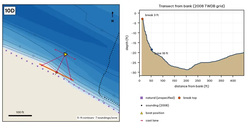
Orange line: break top. Blue dot: base of the break. Black dots: 2008 TWDB soundings. Shoreline squares: bank type (see the Bank-Type Map chapter). Contour interval: 5 ft, at 7 soundings per acre within 250 ft.
| Measure | Value |
|---|---|
| Depth at the bank | 2.9 ft (first wet grid cell, 10 ft from the OSM shoreline) analysis |
| Break top | 3.6 ft, 10 ft from the bank analysis |
| Base of the break | 18.4 ft, 52 ft from the bank analysis |
| Slope | steepest 5.2 ft per 10 ft; average 3.5 ft per 10 ft across the break analysis |
| Bank type | natural (confidence: low) |
| Deep-water access | 20-ft water 60 ft away; 25-ft water 116 ft away; deepest within 300 ft: 30 ft analysis |
| Data support | low (nearest sounding 193 ft away; the break is interpolated) |
Why a giant would use it. A boardwalk-lined south bank that drops from about 4 ft to 18 ft within 52 ft, with 25-ft water within 120 ft. Score factors: cover = boardwalk edge; forage = sunfish; pressure = boardwalk anglers. inference
Wind and current. Best wind: from the NNE (blowing onto this bank) analysis. NNE wind blows onto it. Slight current. inference
Sun and shade today (Oct 12). This is the SW bank of the reach. With 40-ft trees, a shade band of 25 ft or more falls on the water at: 1:00 pm, 2:00 pm, 3:00 pm, 4:00 pm, 5:00 pm, 6:00 pm, 6:30 pm. analysis
Boat position and cast lanes. Hold over about 20 ft, roughly 98 ft off the bank (yellow triangle). Fan three casts to the break top (magenta arrows), then turn and work parallel to the break along the dashed lane inference.
Big-bass plan by season (★ = this spot is a seasonal pick) inference
- Winter / pre-spawn: 3/4–1 oz football jig or 10-in Texas-rigged worm dragged down the face from 4 to 18 ft, then on into the 30-ft water. Long pauses.
- Spawn: Slow-sinking glide counted down to the break top (4 ft), swum along it and killed at the edge.
- Summer: Walking topwater or wake bait along the bank in the first and last hour; a 10–12 in worm on the 18-ft base in between.
- Fall: Swimbait or glide run parallel to the break top as shad push up.
10E · North-bank pier shelf above Festival Beach
#37 of 51Deep water3Cover3Forage3Low pressure3Data2Best: any season (not a seasonal pick)
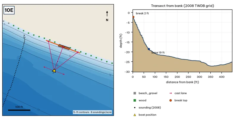
Orange line: break top. Blue dot: base of the break. Black dots: 2008 TWDB soundings. Shoreline squares: bank type (see the Bank-Type Map chapter). Contour interval: 5 ft, at 6 soundings per acre within 250 ft.
| Measure | Value |
|---|---|
| Depth at the bank | 2.2 ft (first wet grid cell, 0 ft from the OSM shoreline) analysis |
| Break top | 2.8 ft, 0 ft from the bank analysis |
| Base of the break | 19.0 ft, 78 ft from the bank analysis |
| Slope | steepest 2.7 ft per 10 ft; average 2.1 ft per 10 ft across the break analysis |
| Bank type | wood (confidence: low-medium) |
| Deep-water access | 20-ft water 89 ft away; 25-ft water 306 ft away; deepest within 300 ft: 25 ft analysis |
| Data support | low (nearest sounding 176 ft away; the break is interpolated) |
Why a giant would use it. A pier on a wooded north shelf above Festival Beach; 19 ft at 78 ft out. Score factors: cover = pier shelf; forage = sunfish; pressure = moderate. inference
Wind and current. Best wind: from the SSW (blowing onto this bank) analysis. SSW wind blows onto it. Slight current. inference
Sun and shade today (Oct 12). This is the NE bank of the reach. With 40-ft trees, a shade band of 25 ft or more falls on the water at: 8:05 am. analysis
Boat position and cast lanes. Hold over about 21 ft, roughly 122 ft off the bank (yellow triangle). Fan three casts to the break top (magenta arrows), then turn and work parallel to the break along the dashed lane inference.
Big-bass plan by season (★ = this spot is a seasonal pick) inference
- Winter / pre-spawn: Suspending jerkbait or a 3/4 oz jig worked slowly off the edge at about 19 ft.
- Spawn: Wake bait or slow glide over the flat, then let it fall off the 3-ft edge, where pre-spawn females stage.
- Summer: Big walking topwater over the flat at dawn and dusk; a 10–12 in worm dragged along the 3–19 ft edge after sun-up.
- Fall: Swimbait run parallel to the edge, best when wind blows onto the flat.