Reach 8 · South First Street to Congress Avenue
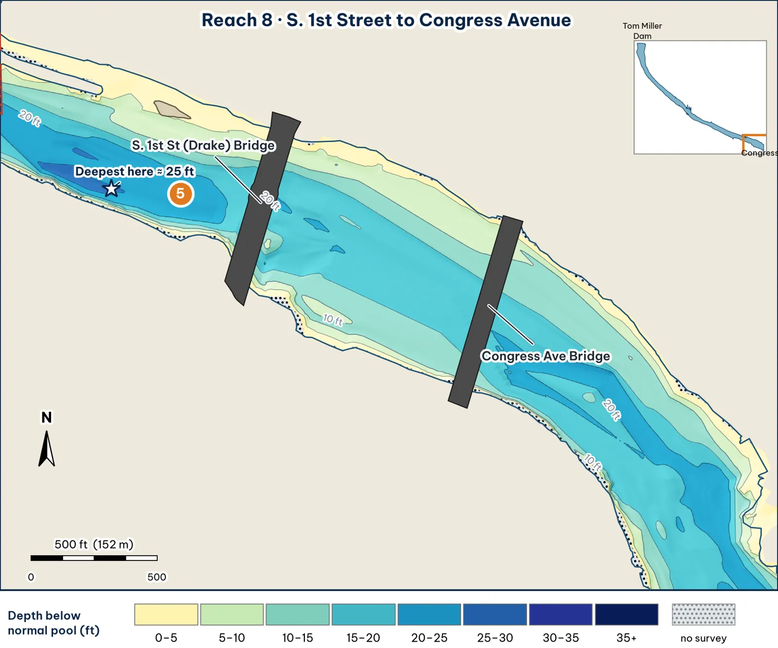
Two big bridges over the widest water in this guide. The deepest cell marked here sits on the tail of the Reach 7 hole, just below First Street analysis.
The bottom
- Wide, with the channel in the middle analysis:
- It's about 715 ft wide, and the deepest point of each cross-section runs 18–20 ft through most of the reach.
- The deeper water just below First Street is the tail of the Reach 7 hole, about 25 ft.
- Banks analysis:
- The north shelf is wide: 10 ft about 145 ft out.
- The south bank is steeper: 10 ft about 50 ft out.
- What the old contours show. TWDB's printed contours show 410-contour (19+ ft) areas around the First Street pilings and just below Congress (TWDB 2008).
Cover and grass
- Bridge pilings. South First Street (Drake) Bridge and Congress Avenue (Ann W. Richards) Bridge (OSM; TPWD paddling trail).
- Grass. Fanwort grows on the north shelf in summer. The City's range for it runs to I-35 inference.
- Bats. Congress is the bat bridge, and crowds gather there on summer evenings (TPWD paddling trail).
Water: clarity and current
- Clarity. Stained to dirty. Visibility keeps dropping toward I-35 (Torwick).
- Current. The river is widest here, so release current is at its weakest analysis.
Through the seasons
| Season | What to expect | Play analysis |
|---|---|---|
| Spring | The north shelf warms | Grass edge on the north shelf |
| Summer | Bat crowds and tour boats at dusk | Early-morning pilings |
| Fall | Stained water | Jig or big worm on the pier bases; swimbait on the shelf edge |
| Winter | Deep pilings | Jig on the 18–20 ft pier bases |
How to fish it for a giant
The Approach
- Where a giant sits. The First Street and Congress pier bases (18–20 ft) and the outer edge of the north shelf analysis.
- How. Pitch a jig or 10-in worm to the deepest piers; swim a glide down the shade line in the morning. Avoid the Congress bat crowds and tour boats at dusk analysis.
- Line. 20–25 lb fluorocarbon at the piers analysis.
Access, hazards and rules
- Access. There are no trailer ramps in this guide's stretch. The nearest are the Holiday Inn ramp (one lane, unimproved, room for about 5 trailers, no fee, west of I-35) and the Festival Beach ramp (TPWD access). The Holiday Inn ramp is about 0.8 miles in a straight line from Congress analysis.
- Rentals. Austin Rowing Club and Congress Avenue Kayaks are at 74 Trinity St., east of Congress (TPWD paddling trail).
Hazard
A submerged dam is documented near the old Green plant intake, but its location is unverified (TWDB 1999) unverified. Watch your graph for a sudden hard rise.
Pro tip
If you launch from the Holiday Inn ramp, this is your first reach. Fish the Congress pilings on the way up while your batteries are fresh, and save some charge for the trip back analysis.
Reach 8 Spots: First Street to Congress
4 spots: 8A, 8B, 8C, 8D. Close-up maps from the 2008 survey; scores from the giant ranking.
8A · South 1st Street Bridge piling row
#11 of 51Deep water3Cover4Forage4Low pressure2Data5Best: Post-spawn and summer
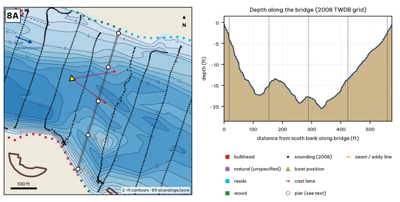
The bridge line is the OSM road or rail centerline. Pier markers are inferred from NBI span counts by assuming equal spans centered on the channel, except at the railroad bridge, where TWDB's footing outlines are used. Orange dashes show where a downstream eddy line should form during a release inference. Contours: 2-ft, at 65 soundings per acre within 250 ft.
| Measure | Value |
|---|---|
| Bridge (NBI 2025) | 6 main + 1 approach spans, 247.5 m (812 ft), longest span 45.7 m (150 ft), built 1951 |
| Water width along the deck | 577 ft (2008 TWDB shoreline) analysis |
| Deepest water under the deck | 20.6 ft, 332 ft from the south end analysis |
| Deep-water access | deepest within 300 ft: 23 ft analysis |
| Data support | 65 soundings per acre; nearest sounding 66 ft from the crossing center |
Why a giant would use it. The South 1st Street Bridge piling row: 6+1 spans (NBI). Score factors: cover = bridge pilings; forage = shad; pressure = downtown. inference
Wind and current. Release seams. Shelter. inference
Sun and shade today (Oct 12). Shade under the deck at all hours. analysis
Boat position and cast lanes. Hold upstream of the deepest span (yellow triangle) and cast down-current to the eddy behind each pier (magenta arrows) inference.
Big-bass plan by season (★ = this spot is a seasonal pick) inference
- Winter / pre-spawn: 3/4 oz football jig or a 10-in Texas-rigged worm crawled along the pier bases in the deepest span (about 21 ft). Pause 5–10 seconds at each pier.
- Spawn: 6–8 in slow-sinking glide (sunfish or shad colors) swum past the shady side of each pier and killed beside it. Give followers the 180° turn.
- ★ Summer: The deck shades the piers all day. Pitch a 3/4 oz jig or a 10-in worm to the pier bases at first light and from dusk to the 10 pm fishing cutoff.
- Fall: 6–7 in swimbait or soft glide down the current seam past each pier when Tom Miller is releasing.
Hazard · Bridge debris Broken concrete and rebar lie under the bridges (City of Austin 2025). Expect snags.
8B · Congress Avenue Bridge piling row
#16 of 51Deep water3Cover4Forage4Low pressure2Data4Best: Post-spawn and summer
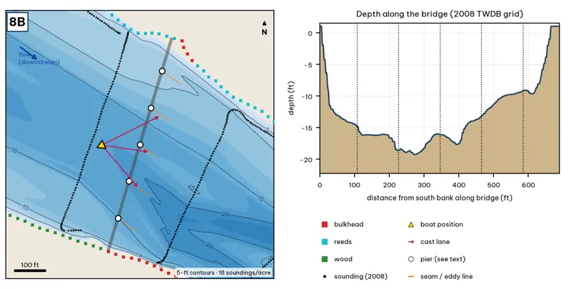
The bridge line is the OSM road or rail centerline. Pier markers are inferred from NBI span counts by assuming equal spans centered on the channel, except at the railroad bridge, where TWDB's footing outlines are used. Orange dashes show where a downstream eddy line should form during a release inference. Contours: 5-ft, at 18 soundings per acre within 250 ft.
| Measure | Value |
|---|---|
| Bridge (NBI 2025) | 8 spans, 290.8 m (954 ft), longest span 36.2 m (119 ft), built 1909 |
| Water width along the deck | 692 ft (2008 TWDB shoreline) analysis |
| Deepest water under the deck | 19.3 ft, 270 ft from the south end analysis |
| Deep-water access | deepest within 300 ft: 22 ft analysis |
| Data support | 18 soundings per acre; nearest sounding 145 ft from the crossing center |
Why a giant would use it. The Congress Avenue Bridge piling row: 8 spans (NBI). Score factors: cover = bridge pilings; forage = shad; pressure = downtown. inference
Wind and current. Release seams. Shelter. inference
Sun and shade today (Oct 12). Shade under the deck at all hours. analysis
Boat position and cast lanes. Hold upstream of the deepest span (yellow triangle) and cast down-current to the eddy behind each pier (magenta arrows) inference.
Big-bass plan by season (★ = this spot is a seasonal pick) inference
- Winter / pre-spawn: 3/4 oz football jig or a 10-in Texas-rigged worm crawled along the pier bases in the deepest span (about 19 ft). Pause 5–10 seconds at each pier.
- Spawn: 6–8 in slow-sinking glide (sunfish or shad colors) swum past the shady side of each pier and killed beside it. Give followers the 180° turn.
- ★ Summer: The deck shades the piers all day. Pitch a 3/4 oz jig or a 10-in worm to the pier bases at first light and from dusk to the 10 pm fishing cutoff.
- Fall: 6–7 in swimbait or soft glide down the current seam past each pier when Tom Miller is releasing.
Hazard · Bridge debris Broken concrete and rebar lie under the bridges (City of Austin 2025). Expect snags.
8C · North-bank reed shelf between the bridges
#47 of 51Deep water1Cover3Forage3Low pressure2Data5Best: any season (not a seasonal pick)
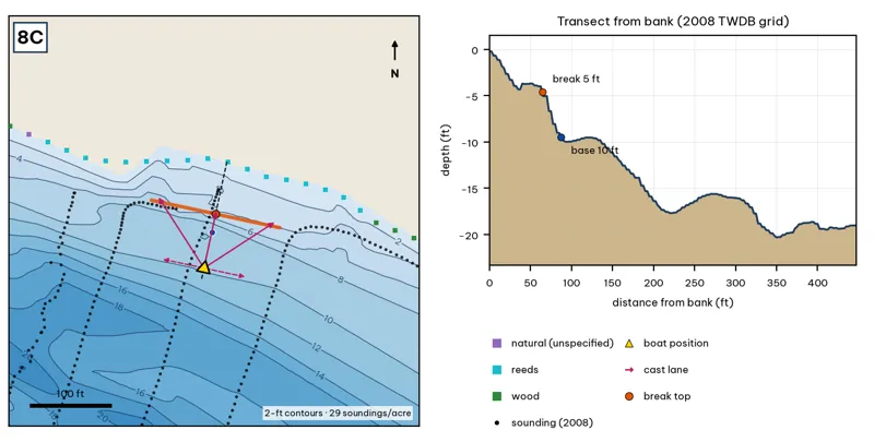
Orange line: break top. Blue dot: base of the break. Black dots: 2008 TWDB soundings. Shoreline squares: bank type (see the Bank-Type Map chapter). Contour interval: 2 ft, at 29 soundings per acre within 250 ft.
| Measure | Value |
|---|---|
| Depth at the bank | 0.2 ft (first wet grid cell, 0 ft from the OSM shoreline) analysis |
| Break top | 4.3 ft, 60 ft from the bank analysis |
| Base of the break | 9.5 ft, 90 ft from the bank analysis |
| Slope | steepest 2.2 ft per 10 ft; average 1.7 ft per 10 ft across the break analysis |
| Bank type | reeds (confidence: medium) |
| Deep-water access | 20-ft water 329 ft away; 25-ft water 892 ft away; deepest within 300 ft: 19 ft analysis |
| Data support | good (a 2008 sounding lies within 15 ft of the break) |
Why a giant would use it. A reed shelf on the north bank: from about 5 to 10 ft at 65–88 ft out. TPWD mapped water willow here in 2019. Score factors: cover = reed shelf; forage = sunfish; pressure = downtown. inference
Wind and current. Best wind: from the SSW (blowing onto this bank) analysis. A SSW wind blows onto it. Mild current. inference
Sun and shade today (Oct 12). This is the NE bank of the reach. With 40-ft trees, a shade band of 25 ft or more falls on the water at: 8:05 am. analysis
Boat position and cast lanes. Hold over about 12 ft, roughly 135 ft off the bank (yellow triangle). Fan three casts to the break top (magenta arrows), then turn and work parallel to the break along the dashed lane inference.
Big-bass plan by season (★ = this spot is a seasonal pick) inference
- Winter / pre-spawn: Suspending jerkbait or a 3/4 oz jig worked slowly off the edge at about 10 ft.
- Spawn: Wake bait or slow glide over the flat, then let it fall off the 4-ft edge, where pre-spawn females stage.
- Summer: Big walking topwater over the flat at dawn and dusk; a 10–12 in worm dragged along the 4–10 ft edge after sun-up.
- Fall: Swimbait run parallel to the edge, best when wind blows onto the flat.
8D · South-shore piers below 1st St
#51 of 51Deep water1Cover4Forage3Low pressure2Data3Best: any season (not a seasonal pick)
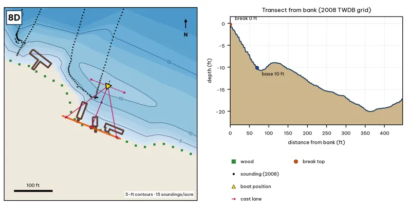
Orange line: break top. Blue dot: base of the break. Black dots: 2008 TWDB soundings. Shoreline squares: bank type (see the Bank-Type Map chapter). Contour interval: 5 ft, at 15 soundings per acre within 250 ft.
| Measure | Value |
|---|---|
| Depth at the bank | 0.3 ft (first wet grid cell, 0 ft from the OSM shoreline) analysis |
| Break top | 0.7 ft, 0 ft from the bank analysis |
| Base of the break | 10.3 ft, 72 ft from the bank analysis |
| Slope | steepest 1.6 ft per 10 ft; average 1.3 ft per 10 ft across the break analysis |
| Bank type | wood (confidence: low-medium) |
| Deep-water access | 20-ft water 341 ft away; 25-ft water 937 ft away; deepest within 300 ft: 20 ft analysis |
| Data support | low (nearest sounding 75 ft away; the break is interpolated) |
Why a giant would use it. South-shore piers below 1st St (OSM), with a slope from 0 to 10 ft at 70 ft out. Score factors: cover = piers; forage = sunfish; pressure = downtown. inference
Wind and current. Best wind: from the NNE (blowing onto this bank) analysis. An NNE wind blows onto it. Mild current. inference
Sun and shade today (Oct 12). This is the SW bank of the reach. With 40-ft trees, a shade band of 25 ft or more falls on the water at: 1:00 pm, 2:00 pm, 3:00 pm, 4:00 pm, 5:00 pm, 6:00 pm, 6:30 pm. analysis
Boat position and cast lanes. Hold over about 12 ft, roughly 118 ft off the bank (yellow triangle). Fan three casts to the break top (magenta arrows), then turn and work parallel to the break along the dashed lane inference.
Big-bass plan by season (★ = this spot is a seasonal pick) inference
- Winter / pre-spawn: 3/4 oz jig crawled down the slope off the dock ends.
- Spawn: Soft glide skipped or 'chopped' beside the dock posts so it hangs near the cover.
- Summer: Skip a jig or a 7-in stick worm deep under the shade; the slope reaches 10 ft about 72 ft out.
- Fall: Swimbait along the outside edge of the dock line.