Reach 12 · Lower Basin and Longhorn Dam
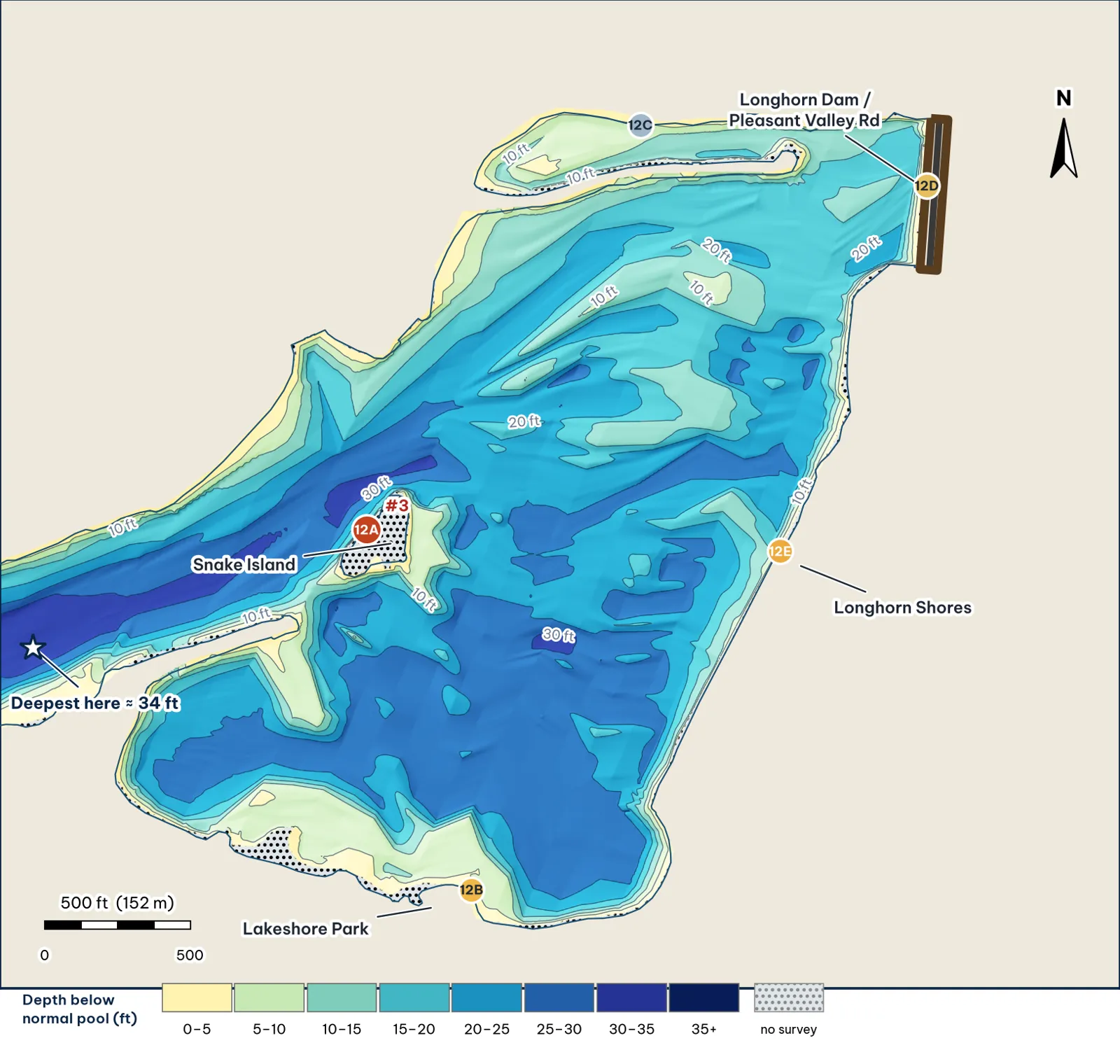
The widest part of the lake: Snake Island, the Lakeshore Park lobe, the Metz-side arm and Longhorn Dam. Depths from my grid of TWDB 2008 points analysis.
The bottom analysis
- A wide basin with a 30-ft channel. The median deepest point is about 27 ft; the deepest cell is about 31 ft, in the channel off Snake Island's west tip (12A).
- The dam face is shallow. Only about 15–21 ft against Longhorn Dam (12D), not the deepest water on the lake.
- Long shelves. The south lobe off Lakeshore Park breaks to about 24 ft roughly 250 ft out (12B); the north arm has a 6–9 ft flat edge (12C).
- Offshore humps. TPWD noted submerged plants on offshore humps near Longhorn Dam (TPWD 2019). The 2008 grid shows one offshore hump east of Congress; I could not tie TPWD's note to it unverified.
Cover and forage
- Snake Island splits the flow at the head of the basin analysis.
- Riprap on the dam face pins bait against the structure inference.
- The least-pressured bank in the guide: the wooded east bank at Longhorn Shores (12E) inference.
- Boggy Creek and Montopolis are below Longhorn Dam, not in the lake analysis.
Through the seasons inference
| Season | Giant play |
|---|---|
| Winter / pre-spawn | Jig on the 30-ft channel off Snake Island (12A) |
| Spawn | The north arm (12C) and the Lakeshore lobe (12B): protected, shallow water near the basin |
| Summer | Wind-blown shelves at dawn; jig on the 12E drop |
| Fall | Glide or swimbait off the island tip and along the dam riprap |
How to fish it for a giant
The Approach
- Island tip. Sit in the channel and cast to the tip, letting a swimbait or glide swing past it with the current analysis.
- Wind. This reach has the longest south-wind fetch east of downtown (median about 1,290 ft), so pick the wind-blown bank in fall and summer analysis.
- Line. 20 lb fluorocarbon analysis.
Access, hazards and rules
- Launch at Festival Beach in Reach 11 (TPWD access).
Longhorn Dam
Longhorn Dam has gates. Keep well back from the structure, and leave if gates are open or water is pulling toward the dam unverified.
Reach 12 Spots: Lower basin, Snake Island and Longhorn Dam
5 spots: 12A, 12B, 12C, 12D, 12E. Close-up maps from the 2008 survey; scores from the giant ranking.
12A · Snake Island west tip and the 30-ft channel
#3 of 51Deep water5Cover4Forage4Low pressure4Data5Best: Winter and pre-spawn · Fall
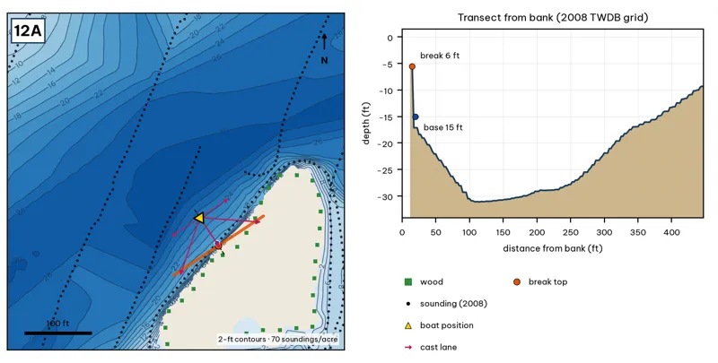
Orange line: break top. Blue dot: base of the break. Black dots: 2008 TWDB soundings. Shoreline squares: bank type (see the Bank-Type Map chapter). Contour interval: 2 ft, at 70 soundings per acre within 250 ft.
| Measure | Value |
|---|---|
| Depth at the bank | 5.6 ft (first wet grid cell, 12 ft from the OSM shoreline) analysis |
| Break top | 9.4 ft, 12 ft from the bank analysis |
| Base of the break | 18.5 ft, 28 ft from the bank analysis |
| Slope | steepest 6.4 ft per 10 ft; average 6.0 ft per 10 ft across the break analysis |
| Bank type | wood (confidence: low-medium) |
| Deep-water access | 20-ft water 35 ft away; 25-ft water 61 ft away; deepest within 300 ft: 31 ft analysis |
| Data support | good (a 2008 sounding lies within 15 ft of the break) |
Why a giant would use it. Snake Island's west tip drops from about 9 ft to 18 ft in under 20 ft, with 30-ft channel water 60 ft away. Island tips concentrate bait, and this one is far from both ramps. Score factors: cover = island tip on a 30-ft channel; forage = bait on the channel edge; pressure = far from ramps. inference
Wind and current. Best wind: from the NNW (blowing onto this bank) analysis. NNW wind blows onto it. Current is weak this close to Longhorn Dam. inference
Sun and shade today (Oct 12). This is the SE bank of the reach. With 40-ft trees, a shade band of 25 ft or more falls on the water at: 8:05 am, 9:00 am, 10:00 am, 11:00 am, 12:00 pm, 1:00 pm, 2:00 pm. analysis
Boat position and cast lanes. Hold over about 20 ft, roughly 72 ft off the bank (yellow triangle). Fan three casts to the break top (magenta arrows), then turn and work parallel to the break along the dashed lane inference.
Big-bass plan by season (★ = this spot is a seasonal pick) inference
- ★ Winter / pre-spawn: 3/4–1 oz football jig or 10-in Texas-rigged worm dragged down the face from 9 to 18 ft, then on into the 31-ft water. Long pauses.
- Spawn: Slow-sinking glide counted down to the break top (9 ft), swum along it and killed at the edge.
- Summer: Walking topwater or wake bait along the bank in the first and last hour; a 10–12 in worm on the 18-ft base in between.
- ★ Fall: Swimbait or glide run parallel to the break top as shad push up.
12B · Lakeshore Park south lobe drop
#18 of 51Deep water2Cover3Forage4Low pressure5Data4Best: Spawn
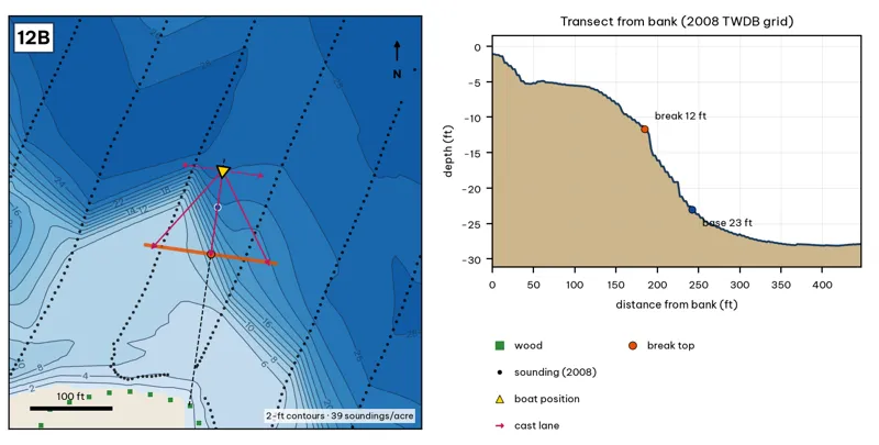
Orange line: break top. Blue dot: base of the break. Black dots: 2008 TWDB soundings. Shoreline squares: bank type (see the Bank-Type Map chapter). Contour interval: 2 ft, at 39 soundings per acre within 250 ft.
| Measure | Value |
|---|---|
| Depth at the bank | 1.1 ft (first wet grid cell, 0 ft from the OSM shoreline) analysis |
| Break top | 10.7 ft, 175 ft from the bank analysis |
| Base of the break | 24.1 ft, 252 ft from the bank analysis |
| Slope | steepest 2.5 ft per 10 ft; average 1.7 ft per 10 ft across the break analysis |
| Bank type | wood (confidence: low-medium) |
| Deep-water access | 20-ft water 156 ft away; 25-ft water 191 ft away; deepest within 300 ft: 28 ft analysis |
| Data support | fair (nearest sounding 37 ft from the break) |
Why a giant would use it. The south lobe of the lower basin: a long shallow shelf off Lakeshore Park breaking to about 24 ft roughly 250 ft out. TPWD reports submerged plants on offshore humps in the lower lake near Longhorn Dam. Score factors: cover = basin drop, offshore humps (TPWD grass); forage = bait on humps; pressure = farthest from ramps. inference
Wind and current. Best wind: from the N (blowing onto this bank) analysis. N wind blows onto it; the long S fetch (up to about 2,200 ft) builds waves from the south. Almost none. inference
Sun and shade today (Oct 12). This is the SE bank of the reach. With 40-ft trees, a shade band of 25 ft or more falls on the water at: 8:05 am, 9:00 am, 10:00 am, 11:00 am, 12:00 pm, 1:00 pm, 2:00 pm. analysis
Boat position and cast lanes. Hold over about 26 ft, roughly 298 ft off the bank (yellow triangle). Fan three casts to the break top (magenta arrows), then turn and work parallel to the break along the dashed lane inference.
Big-bass plan by season (★ = this spot is a seasonal pick) inference
- Winter / pre-spawn: 3/4–1 oz football jig or 10-in Texas-rigged worm dragged down the face from 11 to 24 ft. Long pauses.
- ★ Spawn: Slow-sinking glide counted down to the break top (11 ft), swum along it and killed at the edge.
- Summer: Walking topwater or wake bait along the bank in the first and last hour; a 10–12 in worm on the 24-ft base in between.
- Fall: Swimbait or glide run parallel to the break top as shad push up.
12C · North arm flat edge (Metz side)
#49 of 51Deep water1Cover2Forage3Low pressure4Data4Best: Spawn
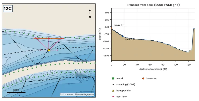
Orange line: break top. Blue dot: base of the break. Black dots: 2008 TWDB soundings. Shoreline squares: bank type (see the Bank-Type Map chapter). Contour interval: 2 ft, at 45 soundings per acre within 250 ft.
| Measure | Value |
|---|---|
| Depth at the bank | 5.5 ft (first wet grid cell, 0 ft from the OSM shoreline) analysis |
| Break top | 6.0 ft, 0 ft from the bank analysis |
| Base of the break | 8.8 ft, 25 ft from the bank analysis |
| Slope | steepest 1.4 ft per 10 ft; average 1.1 ft per 10 ft across the break analysis |
| Bank type | wood (confidence: low-medium) |
| Deep-water access | 20-ft water 340 ft away; 25-ft water 825 ft away; deepest within 300 ft: 18 ft analysis |
| Data support | fair (nearest sounding 37 ft from the break) |
Why a giant would use it. A protected north arm with a 6–9 ft flat edge. It is spawning-type water close to deeper basin water. Score factors: cover = flat edge; forage = sunfish; pressure = quiet arm. inference
Wind and current. Best wind: from the S (blowing onto this bank) analysis. S wind blows onto it. None. inference
Sun and shade today (Oct 12). This is the NW bank of the reach. With 40-ft trees, a shade band of 25 ft or more falls on the water at: 6:30 pm. analysis
Boat position and cast lanes. Hold over about 11 ft, roughly 70 ft off the bank (yellow triangle). Fan three casts to the break top (magenta arrows), then turn and work parallel to the break along the dashed lane inference.
Big-bass plan by season (★ = this spot is a seasonal pick) inference
- Winter / pre-spawn: Suspending jerkbait or a 3/4 oz jig worked slowly off the edge at about 9 ft.
- ★ Spawn: Wake bait or slow glide over the flat, then let it fall off the 6-ft edge, where pre-spawn females stage.
- Summer: Big walking topwater over the flat at dawn and dusk; a 10–12 in worm dragged along the 6–9 ft edge after sun-up.
- Fall: Swimbait run parallel to the edge, best when wind blows onto the flat.
12D · Longhorn Dam face
#23 of 51Deep water2Cover4Forage3Low pressure4Data4Best: Fall
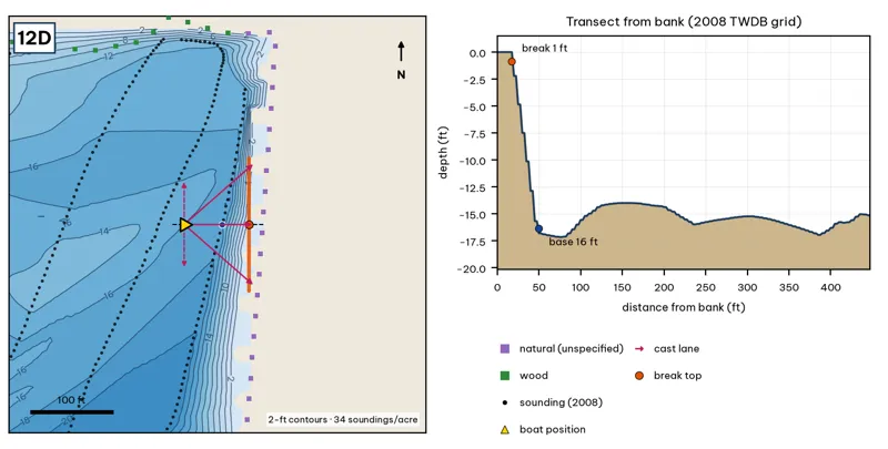
Orange line: break top. Blue dot: base of the break. Black dots: 2008 TWDB soundings. Shoreline squares: bank type (see the Bank-Type Map chapter). Contour interval: 2 ft, at 34 soundings per acre within 250 ft.
| Measure | Value |
|---|---|
| Depth at the bank | 0.0 ft (first wet grid cell, 0 ft from the OSM shoreline) analysis |
| Break top | 1.0 ft, 15 ft from the bank analysis |
| Base of the break | 15.7 ft, 50 ft from the bank analysis |
| Slope | steepest 5.4 ft per 10 ft; average 4.2 ft per 10 ft across the break analysis |
| Bank type | natural (confidence: low) |
| Deep-water access | 20-ft water 153 ft away; 25-ft water 644 ft away; deepest within 300 ft: 21 ft analysis |
| Data support | fair (nearest sounding 34 ft from the break) |
Why a giant would use it. The face of Longhorn Dam: about 16 ft at 50 ft out, along riprap. Bait gets pinned against the dam. Score factors: cover = dam riprap; forage = bait pinned at the dam; pressure = quiet. inference
Wind and current. Best wind: from the W (blowing onto this bank) analysis. W wind blows onto the dam face. Gate releases pull water toward the dam. Stay well back from the gates. inference
Sun and shade today (Oct 12). This is the SE bank of the reach. With 40-ft trees, a shade band of 25 ft or more falls on the water at: 8:05 am, 9:00 am, 10:00 am, 11:00 am, 12:00 pm, 1:00 pm, 2:00 pm. analysis
Boat position and cast lanes. Hold over about 17 ft, roughly 95 ft off the bank (yellow triangle). Fan three casts to the break top (magenta arrows), then turn and work parallel to the break along the dashed lane inference.
Big-bass plan by season (★ = this spot is a seasonal pick) inference
- Winter / pre-spawn: 3/4–1 oz football jig or 10-in Texas-rigged worm dragged down the face from 1 to 16 ft, then on into the 21-ft water. Long pauses.
- Spawn: Slow-sinking glide counted down to the break top (1 ft), swum along it and killed at the edge.
- Summer: Walking topwater or wake bait along the bank in the first and last hour; a 10–12 in worm on the 16-ft base in between.
- ★ Fall: Swimbait or glide run parallel to the break top as shad push up.
Hazard · Dam gates Longhorn Dam has gates and a spillway. Keep well back from the structure, and leave if gates are open or flow is pulling toward the dam unverified.
12E · Longhorn Shores bank drop (east bank)
#14 of 51Deep water3Cover3Forage3Low pressure5Data4Best: any season (not a seasonal pick)
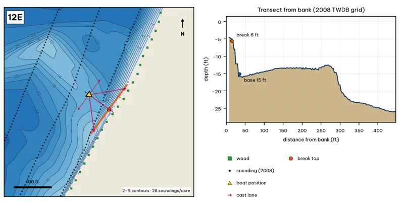
Orange line: break top. Blue dot: base of the break. Black dots: 2008 TWDB soundings. Shoreline squares: bank type (see the Bank-Type Map chapter). Contour interval: 2 ft, at 28 soundings per acre within 250 ft.
| Measure | Value |
|---|---|
| Depth at the bank | 4.7 ft (first wet grid cell, 8 ft from the OSM shoreline) analysis |
| Break top | 5.6 ft, 12 ft from the bank analysis |
| Base of the break | 14.7 ft, 35 ft from the bank analysis |
| Slope | steepest 4.9 ft per 10 ft; average 4.1 ft per 10 ft across the break analysis |
| Bank type | wood (confidence: low-medium) |
| Deep-water access | 20-ft water 71 ft away; 25-ft water 225 ft away; deepest within 300 ft: 26 ft analysis |
| Data support | fair (nearest sounding 24 ft from the break) |
Why a giant would use it. A wooded east bank (Longhorn Shores) with a 6-ft to 15-ft break within 35 ft and 25-ft water within 225 ft. It is the least-pressured bank in the guide. Score factors: cover = wooded bank drop; forage = sunfish; pressure = quiet. inference
Wind and current. Best wind: from the NW (blowing onto this bank) analysis. NW wind blows onto it. Little current. inference
Sun and shade today (Oct 12). This is the SE bank of the reach. With 40-ft trees, a shade band of 25 ft or more falls on the water at: 8:05 am, 9:00 am, 10:00 am, 11:00 am, 12:00 pm, 1:00 pm, 2:00 pm. analysis
Boat position and cast lanes. Hold over about 17 ft, roughly 80 ft off the bank (yellow triangle). Fan three casts to the break top (magenta arrows), then turn and work parallel to the break along the dashed lane inference.
Big-bass plan by season (★ = this spot is a seasonal pick) inference
- Winter / pre-spawn: 3/4–1 oz football jig or 10-in Texas-rigged worm dragged down the face from 6 to 15 ft, then on into the 26-ft water. Long pauses.
- Spawn: Slow-sinking glide counted down to the break top (6 ft), swum along it and killed at the edge.
- Summer: Walking topwater or wake bait along the bank in the first and last hour; a 10–12 in worm on the 15-ft base in between.
- Fall: Swimbait or glide run parallel to the break top as shad push up.