Reach 2 · Red Bud to MoPac
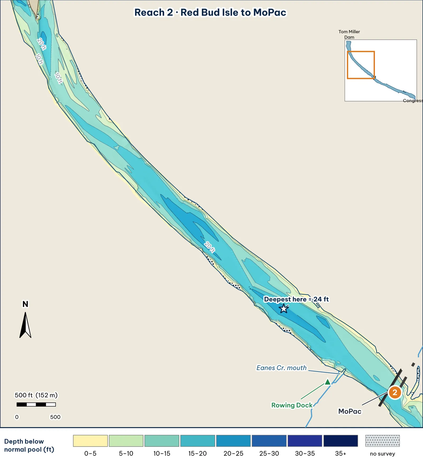
Red Bud to MoPac: the longest, most uniform reach. A deep channel runs between two steep banks.
The bottom
- It's a narrow, deep river channel. The reach is about 450 ft wide (roughly 420–550 ft). Across the reach, the deepest point of each cross-section runs 15–24 ft, with a median of about 20 ft analysis. The deepest cell, about 24 ft, sits about 1.4 miles below the dam (see the star on the map).
- The channel favors the south (right) bank. Its deepest line runs about 160 ft off the south bank and about 325 ft off the north bank (medians) analysis.
-
Both banks drop fast analysis:
- 5 ft within about 20 ft of either bank.
- 10 ft within about 40–45 ft of either bank.
- 15 ft: about 80 ft off the south bank, and about 120 ft off the north bank.
The south bank is the steeper channel wall, and the north side has a slightly wider shoulder. - No textbook ledge. In 1999, TWDB reported "no distinct river channel" between Longhorn Dam and Red Bud and called the bottom "quite irregular" (TWDB 1999). Expect humps and troughs rather than a clean ledge. The flat-bottomed cross-section in the front of this guide shows this.
Cover and grass
- Steep banks with wood. TPWD says most of the lake's cover is along the bank: "laydown logs and trees, overhanging brush, cypress tree roots, bulrush, and cattails" (TPWD). Bald cypress, sycamore, cottonwood and elm line the banks (TPWD paddling trail).
- Grass. Fanwort grows through this reach, which falls inside the City's "from Red Bud to I-35" range (City of Austin, FY2024–25). With the banks this steep, the strip of bottom that's shallow enough for grass is narrow analysis.
Water: clarity and current
- Clarity. Clear: this reach is above Lamar (City of Austin, FY2023).
- Current. The river is narrow here, so release current stays concentrated through the whole reach analysis.
Through the seasons
| Season | What to expect | Play analysis |
|---|---|---|
| Spring | Clear water, and fish using submerged grass (Captain Experiences) | Parallel the 5–10 ft band along both banks. Natural colors |
| Summer | Fanwort at the surface from July to September (City). Stained, with 2–3 ft visibility, at about 81°F in mid-summer 2026 (Captain Experiences) | Low light. Shade lines under the cypress. Work the outer grass edge |
| Fall | Grass tops back below the surface (City) | Soft glide or swimbait parallel to the banks while the grass is thin |
| Winter | Cold, with less flow (TXST 2019) | Jig or big worm on the south channel wall, 12–18 ft |
How to fish it for a giant
The Approach
- Where a giant sits. Cypress roots and laydowns on the steep south (right) bank, where 15 ft is within about 80 ft of the bank analysis.
- Boat position. About 50–70 ft off the bank, over 10–15 ft. Cast at a shallow angle, nearly parallel to the bank analysis.
- Baits. Skip a 3/4 oz jig or a 7-in stick worm into the root wads; swim a soft glide or 6-in swimbait down the bank in low light. A weightless soft jerkbait (Fluke) is worth trying around wood in clear water; the lake record ate one inference.
- Line. 20 lb fluorocarbon around wood analysis.
Access, hazards and rules
- Access. Carry in at Red Bud at the top of the reach. Rowing Dock (2418 Stratford Dr., on the south shore just west of MoPac) rents kayaks for $20–25 an hour (Rowing Dock).
Rule
Traffic rule: "east-bound traffic should stay on the south side, the west-bound traffic should stay on the north side," and the central channel is kept for fast-moving racing shells (Austin Rowing Club). Fish the bank lanes, not the middle.
Pro tip
Look at the cross-sections in the front of this guide. The south bank reaches 15 ft about 40 ft sooner than the north bank does. On a cold day, the south wall puts deep water within one cast of the cover analysis.
Reach 2 Spots: Red Bud to MoPac
4 spots: 2A, 2B, 2C, 2D. Close-up maps from the 2008 survey; scores from the giant ranking.
2A · South-bank rock bluff
#10 of 51Deep water3Cover4Forage3Low pressure4Data4Best: Winter and pre-spawn
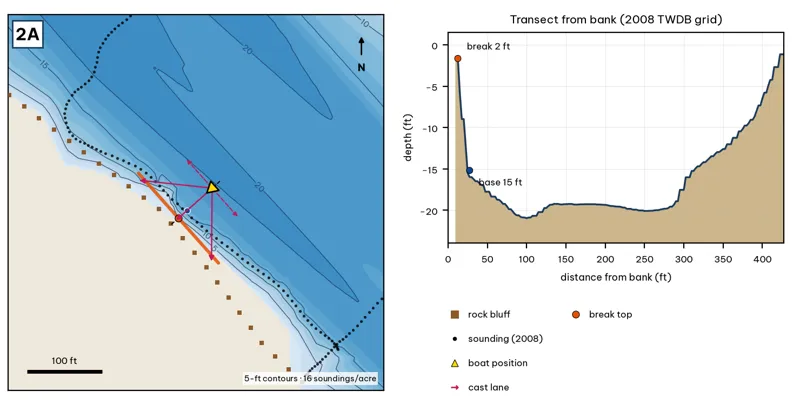
Orange line: break top. Blue dot: base of the break. Black dots: 2008 TWDB soundings. Shoreline squares: bank type (see the Bank-Type Map chapter). Contour interval: 5 ft, at 16 soundings per acre within 250 ft.
| Measure | Value |
|---|---|
| Depth at the bank | 1.7 ft (first wet grid cell, 10 ft from the OSM shoreline) analysis |
| Break top | 3.7 ft, 10 ft from the bank analysis |
| Base of the break | 15.8 ft, 32 ft from the bank analysis |
| Slope | steepest 6.5 ft per 10 ft; average 5.4 ft per 10 ft across the break analysis |
| Bank type | rock bluff (confidence: medium) |
| Deep-water access | 20-ft water 81 ft away; 25-ft water 5697 ft away; deepest within 300 ft: 22 ft analysis |
| Data support | fair (nearest sounding 16 ft from the break) |
Why a giant would use it. The best example of a true channel wall in the guide: TPWD-mapped rock bluff that drops from about 2 ft to 15 ft in about 16 ft of distance, with the 20-ft channel right outside it. Bass can move vertically without moving far. Score factors: cover = TPWD-mapped rock bluff; forage = crawfish, sunfish; pressure = quiet stretch. inference
Wind and current. Best wind: from the NE (blowing onto this bank) analysis. A NE wind blows onto it. Under S/SE winds this bank is in the lee. The narrow reach keeps release current concentrated against this wall. inference
Sun and shade today (Oct 12). This is the SW bank of the reach. With 40-ft trees, a shade band of 25 ft or more falls on the water at: 2:00 pm, 3:00 pm, 4:00 pm, 5:00 pm, 6:00 pm, 6:30 pm. analysis
Boat position and cast lanes. Hold over about 18 ft, roughly 78 ft off the bank (yellow triangle). Fan three casts to the break top (magenta arrows), then turn and work parallel to the break along the dashed lane inference.
Big-bass plan by season (★ = this spot is a seasonal pick) inference
- ★ Winter / pre-spawn: 3/4–1 oz football jig or 10-in Texas-rigged worm dragged down the face from 4 to 16 ft, then on into the 22-ft water. Long pauses.
- Spawn: Slow-sinking glide counted down to the break top (4 ft), swum along it and killed at the edge.
- Summer: Walking topwater or wake bait along the bank in the first and last hour; a 10–12 in worm on the 16-ft base in between.
- Fall: Swimbait or glide run parallel to the break top as shad push up.
2B · The 24-ft trough
#15 of 51Deep water3Cover3Forage3Low pressure4Data4Best: any season (not a seasonal pick)
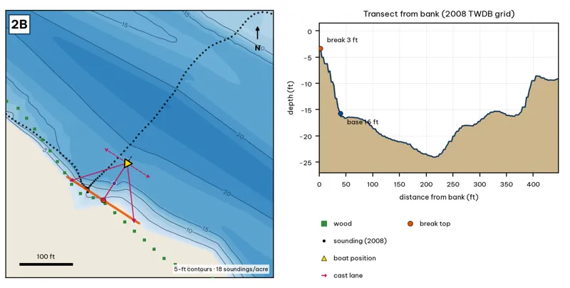
Orange line: break top. Blue dot: base of the break. Black dots: 2008 TWDB soundings. Shoreline squares: bank type (see the Bank-Type Map chapter). Contour interval: 5 ft, at 18 soundings per acre within 250 ft.
| Measure | Value |
|---|---|
| Depth at the bank | 3.4 ft (first wet grid cell, 0 ft from the OSM shoreline) analysis |
| Break top | 4.7 ft, 5 ft from the bank analysis |
| Base of the break | 15.7 ft, 42 ft from the bank analysis |
| Slope | steepest 3.9 ft per 10 ft; average 2.9 ft per 10 ft across the break analysis |
| Bank type | wood (confidence: low-medium) |
| Deep-water access | 20-ft water 116 ft away; 25-ft water 6923 ft away; deepest within 300 ft: 24 ft analysis |
| Data support | fair (nearest sounding 33 ft from the break) |
Why a giant would use it. The south-bank approach to the 24-ft trough, the deepest water between Red Bud and MoPac. Deep-water refuge next to the wooded bank. Score factors: cover = wooded bank over trough; forage = sunfish; pressure = quiet stretch. inference
Wind and current. Best wind: from the NNE (blowing onto this bank) analysis. An NNE wind blows onto this bank (rare). S/SE winds leave it in the lee. Release current speeds up over the trough; fish the upstream lip. inference
Sun and shade today (Oct 12). This is the SW bank of the reach. With 40-ft trees, a shade band of 25 ft or more falls on the water at: 2:00 pm, 3:00 pm, 4:00 pm, 5:00 pm, 6:00 pm, 6:30 pm. analysis
Boat position and cast lanes. Hold over about 18 ft, roughly 88 ft off the bank (yellow triangle). Fan three casts to the break top (magenta arrows), then turn and work parallel to the break along the dashed lane inference.
Big-bass plan by season (★ = this spot is a seasonal pick) inference
- Winter / pre-spawn: 3/4–1 oz football jig or 10-in Texas-rigged worm dragged down the face from 5 to 16 ft, then on into the 24-ft water. Long pauses.
- Spawn: Slow-sinking glide counted down to the break top (5 ft), swum along it and killed at the edge.
- Summer: Walking topwater or wake bait along the bank in the first and last hour; a 10–12 in worm on the 16-ft base in between.
- Fall: Swimbait or glide run parallel to the break top as shad push up.
2C · Deep Eddy / Eilers Park north shelf
#50 of 51Deep water1Cover2Forage3Low pressure3Data4Best: any season (not a seasonal pick)
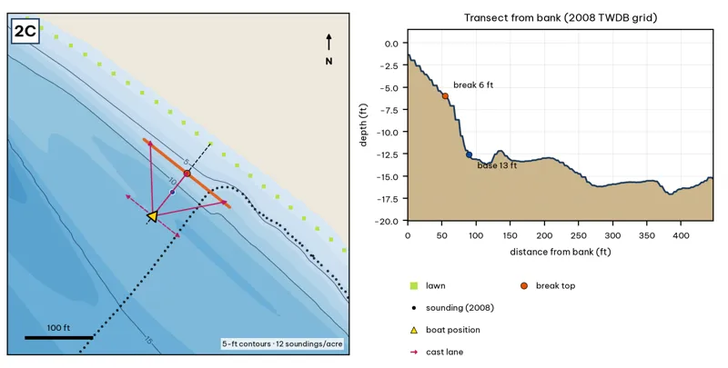
Orange line: break top. Blue dot: base of the break. Black dots: 2008 TWDB soundings. Shoreline squares: bank type (see the Bank-Type Map chapter). Contour interval: 5 ft, at 12 soundings per acre within 250 ft.
| Measure | Value |
|---|---|
| Depth at the bank | 1.4 ft (first wet grid cell, 0 ft from the OSM shoreline) analysis |
| Break top | 5.6 ft, 50 ft from the bank analysis |
| Base of the break | 12.7 ft, 92 ft from the bank analysis |
| Slope | steepest 2.4 ft per 10 ft; average 1.7 ft per 10 ft across the break analysis |
| Bank type | lawn (confidence: low-medium) |
| Deep-water access | 20-ft water 381 ft away; 25-ft water 7592 ft away; deepest within 300 ft: 19 ft analysis |
| Data support | fair (nearest sounding 43 ft from the break) |
Why a giant would use it. A lawn-bank shelf at Eilers Park: 2–6 ft flat out to about 55 ft, then a soft break to 12–13 ft. Shelf edges like this are where shad and sunfish get pinned. Score factors: cover = shelf, lawn bank; forage = sunfish; pressure = park bank access. inference
Wind and current. Best wind: from the SW (blowing onto this bank) analysis. A SW wind blows onto it. Weak current along the shelf; the edge sees a little more flow. inference
Sun and shade today (Oct 12). This is the NE bank of the reach. With 40-ft trees, a shade band of 25 ft or more falls on the water at: 8:05 am, 9:00 am. analysis
Boat position and cast lanes. Hold over about 15 ft, roughly 138 ft off the bank (yellow triangle). Fan three casts to the break top (magenta arrows), then turn and work parallel to the break along the dashed lane inference.
Big-bass plan by season (★ = this spot is a seasonal pick) inference
- Winter / pre-spawn: Suspending jerkbait or a 3/4 oz jig worked slowly off the edge at about 13 ft.
- Spawn: Wake bait or slow glide over the flat, then let it fall off the 6-ft edge, where pre-spawn females stage.
- Summer: Big walking topwater over the flat at dawn and dusk; a 10–12 in worm dragged along the 6–13 ft edge after sun-up.
- Fall: Swimbait run parallel to the edge, best when wind blows onto the flat.
2D · Eanes Creek mouth
#39 of 51Deep water2Cover3Forage4Low pressure3Data2Best: Spawn
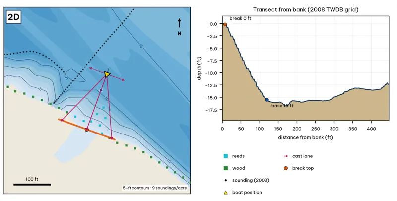
Orange line: break top. Blue dot: base of the break. Black dots: 2008 TWDB soundings. Shoreline squares: bank type (see the Bank-Type Map chapter). Contour interval: 5 ft, at 9 soundings per acre within 250 ft.
| Measure | Value |
|---|---|
| Depth at the bank | 0.0 ft (first wet grid cell, 0 ft from the OSM shoreline) analysis |
| Break top | 0.4 ft, 8 ft from the bank analysis |
| Base of the break | 15.3 ft, 118 ft from the bank analysis |
| Slope | steepest 1.7 ft per 10 ft; average 1.4 ft per 10 ft across the break analysis |
| Bank type | reeds (confidence: medium) |
| Deep-water access | 20-ft water 459 ft away; 25-ft water 7920 ft away; deepest within 300 ft: 20 ft analysis |
| Data support | low (nearest sounding 113 ft away; the break is interpolated) |
Why a giant would use it. The Eanes Creek mouth. It has a small delta and reeds; after rain it carries a mud line and fresh food. Score factors: cover = creek delta, reeds; forage = creek inflow bait; pressure = paddle traffic. inference
Wind and current. Best wind: from the NNE (blowing onto this bank) analysis. An NNE wind blows into the mouth. Creek inflow after rain. The lake current here is moderate. inference
Sun and shade today (Oct 12). This is the SW bank of the reach. With 40-ft trees, a shade band of 25 ft or more falls on the water at: 2:00 pm, 3:00 pm, 4:00 pm, 5:00 pm, 6:00 pm, 6:30 pm. analysis
Boat position and cast lanes. Hold over about 17 ft, roughly 162 ft off the bank (yellow triangle). Fan three casts to the break top (magenta arrows), then turn and work parallel to the break along the dashed lane inference.
Big-bass plan by season (★ = this spot is a seasonal pick) inference
- Winter / pre-spawn: Jig or big Texas-rigged worm crawled down the delta slope to 15 ft. Go slow.
- ★ Spawn: Sight-fish from a distance in clear water: weightless soft jerkbait (Fluke) or stick worm to beds on the delta. The lake record (14.05 lb) took a Zoom Fluke from a creek in February.
- Summer: Walking bait or wake bait over the delta at dawn. After a storm, a big white spinnerbait along the mud line.
- Fall: Glide or swimbait across the delta lip (0–15 ft) as shad move toward the creek.