Reach 7 · Shoal Creek to South First Street
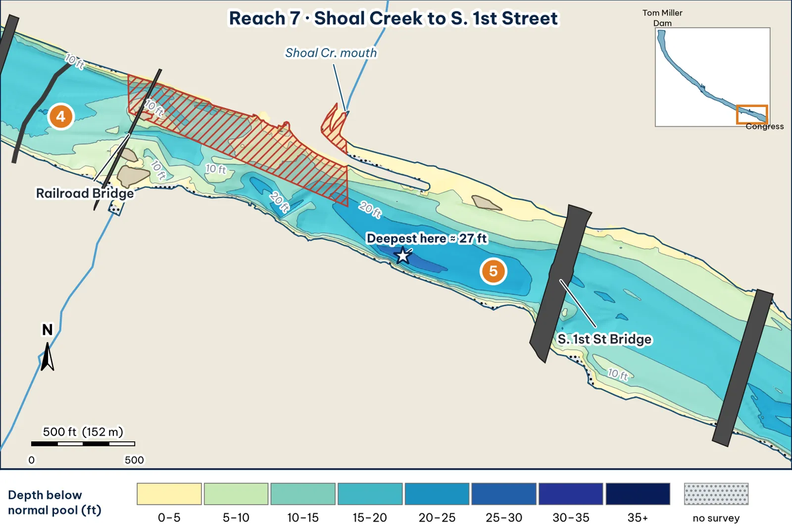
The second-deepest water in this guide. A trough runs along the south bank opposite the Shoal Creek delta.
The bottom
- The channel swings hard to the south bank analysis:
- It's about 440 ft wide, and the deepest point of each cross-section runs 12–27 ft.
- The deepest line runs about 95 ft off the south bank.
- The south bank is a wall: 10 ft within about 20 ft, and 15 ft within about 30 ft.
- The deep hole. It reaches about 27.5 ft, about 3.25 miles below the dam, roughly halfway between Shoal Creek and First Street, near the south bank analysis. TWDB's printed contours show a 405 contour here, meaning 24+ ft (TWDB 2008).
-
The Shoal Creek delta (north side) analysis:
- 5 ft about 40 ft out.
- 10 ft about 115 ft out.
- 15 ft about 200 ft out.
On the sample cross-section, the bottom stays shallower than about 5 ft for the first 100 ft from the north bank, then slides down to 25 ft.
Cover and grass
- Grass at the creek mouth. Shoal Creek's mouth has a City trash boom, and a shore-to-shore fanwort mat formed behind it in 2014 (Shoal Creek Conservancy).
- Hard bottom or snags. TWDB mapped "a shallow water dam that spans across the lake near the intake structure at Green Water Treatment facility" (TWDB 1999). The old Green plant stood downtown on the north shore, and the City listed its "abandoned intake structure" for a 3-D scan in 2025 (City of Austin). The exact location of the submerged dam is unverified unverified.
Water: clarity and current
- Clarity. Stained. This is the first water to muddy after rain, because Shoal Creek, West Bouldin Creek and downtown storm drains all come in here (analysis; TXST 2019).
- Bacteria. E. coli rises at every City site, including First Street, one to two days after rain (City of Austin 2020).
- Temperature. Long-term samples at Auditorium Shores, across from Shoal Creek, ranged from 41°F to 98°F (TXST 2019).
Through the seasons
| Season | What to expect | Play analysis |
|---|---|---|
| Spring | Delta flat warms | The outer edge of the Shoal delta |
| Summer | The widest temperature swings on the stretch (TXST) | Low light only. The south wall in shade |
| Fall | Stained water and grass on the delta | Glide on the delta lip; jig on the wall |
| Winter | Deep water right next to the bank | Football jig down the south wall to 20 ft |
How to fish it for a giant
The Approach
- Where a giant sits. The steep south wall below Shoal Creek, the deepest bank on the upper lake (15–25 ft within one cast), and the outer lip of the Shoal Creek delta analysis.
- The south wall. Sit 50–70 ft off the south bank. Count a glide or swimbait down 5–10 seconds and swim it parallel to the wall. In winter, crawl a football jig down the wall to 20+ ft analysis.
- The delta lip. Sit in about 15 ft, roughly 200 ft off the north bank, and work a glide or big worm down the slope analysis.
- Line. 20 lb fluorocarbon analysis.
Access, hazards and rules
- Access. Bank fishing at Auditorium Shores, which TPWD lists as good bank access (TPWD access).
Rule
The no-boat zone runs from the railroad bridge to the Shoal Creek mouth, north of the centerline. Fish the delta east of the creek mouth or south of the centerline (City code 8-5-82).
Hazard
- The ARC map marks "unmarked hazards (shallow)" on the north side just upstream of First Street (ARC map).
- The City advises staying out of the water for three days after rain (City of Austin).
Pro tip
This is the only place in the guide where a 15-ft drop and a 27-ft hole sit on opposite sides of the same 440-ft-wide river. A slow, deep presentation along the south wall is the coldest-weather play below Barton analysis.
Reach 7 Spots: Shoal Creek to First Street
3 spots: 7A, 7B, 7C. Close-up maps from the 2008 survey; scores from the giant ranking.
7A · South wall at the 27-ft hole
#8 of 51Deep water5Cover3Forage3Low pressure2Data4Best: Winter and pre-spawn
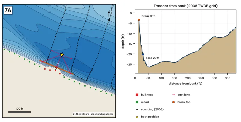
Orange line: break top. Blue dot: base of the break. Black dots: 2008 TWDB soundings. Shoreline squares: bank type (see the Bank-Type Map chapter). Contour interval: 2 ft, at 25 soundings per acre within 250 ft.
| Measure | Value |
|---|---|
| Depth at the bank | 3.3 ft (first wet grid cell, 12 ft from the OSM shoreline) analysis |
| Break top | 6.2 ft, 12 ft from the bank analysis |
| Base of the break | 24.1 ft, 40 ft from the bank analysis |
| Slope | steepest 8.9 ft per 10 ft; average 6.5 ft per 10 ft across the break analysis |
| Bank type | bulkhead (confidence: medium) |
| Deep-water access | 20-ft water 29 ft away; 25-ft water 40 ft away; deepest within 300 ft: 27 ft analysis |
| Data support | fair (nearest sounding 50 ft from the break) |
Why a giant would use it. The steepest wall in the guide: a bulkhead drops from about 3 to 20 ft within 15 ft, next to the 27-ft hole. Score factors: cover = bulkhead into 27-ft hole; forage = sunfish, shad; pressure = downtown. inference
Wind and current. Best wind: from the NNE (blowing onto this bank) analysis. An NNE wind blows onto it. Moderate current. inference
Sun and shade today (Oct 12). This is the S bank of the reach. With 40-ft trees, a shade band of 25 ft or more falls on the water at: 1:00 pm, 2:00 pm, 3:00 pm, 4:00 pm, 5:00 pm, 6:00 pm, 6:30 pm. analysis
Boat position and cast lanes. Hold over about 26 ft, roughly 85 ft off the bank (yellow triangle). Fan three casts to the break top (magenta arrows), then turn and work parallel to the break along the dashed lane inference.
Big-bass plan by season (★ = this spot is a seasonal pick) inference
- ★ Winter / pre-spawn: 3/4–1 oz football jig or 10-in Texas-rigged worm dragged down the face from 6 to 24 ft. Long pauses.
- Spawn: Slow-sinking glide counted down to the break top (6 ft), swum along it and killed at the edge.
- Summer: Walking topwater or wake bait along the bank in the first and last hour; a 10–12 in worm on the 24-ft base in between.
- Fall: Swimbait or glide run parallel to the break top as shad push up.
7B · Shoal Creek delta lip
#34 of 51Deep water2Cover3Forage4Low pressure2Data4Best: Spawn
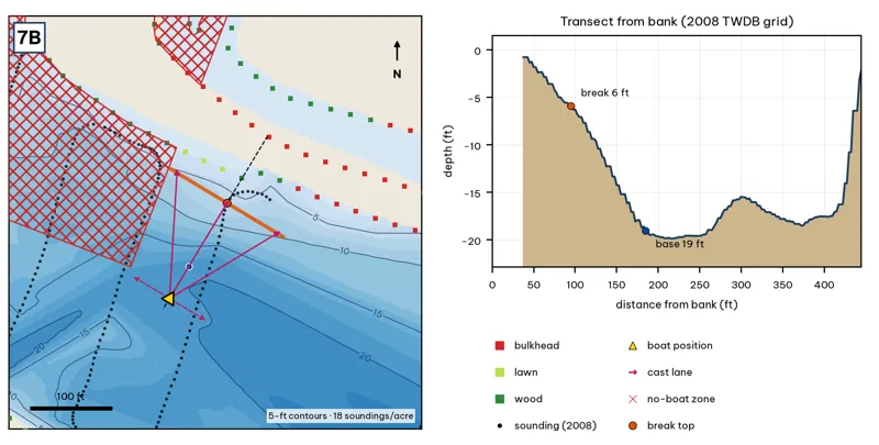
Orange line: break top. Blue dot: base of the break. Black dots: 2008 TWDB soundings. Shoreline squares: bank type (see the Bank-Type Map chapter). Contour interval: 5 ft, at 18 soundings per acre within 250 ft.
| Measure | Value |
|---|---|
| Depth at the bank | 0.8 ft (first wet grid cell, 38 ft from the OSM shoreline) analysis |
| Break top | 1.3 ft, 45 ft from the bank analysis |
| Base of the break | 19.1 ft, 188 ft from the bank analysis |
| Slope | steepest 1.7 ft per 10 ft; average 1.2 ft per 10 ft across the break analysis |
| Bank type | bulkhead (confidence: medium) |
| Deep-water access | 20-ft water 188 ft away; 25-ft water 455 ft away; deepest within 300 ft: 22 ft analysis |
| Data support | fair (nearest sounding 28 ft from the break) |
Why a giant would use it. The lip of the Shoal Creek delta: about 6 ft at 95 ft from the bank to 19 ft at 185 ft. Score factors: cover = creek delta; forage = creek inflow; pressure = downtown. inference
Wind and current. Best wind: from the SSW (blowing onto this bank) analysis. A SSW wind blows onto it. Creek inflow after rain. inference
Sun and shade today (Oct 12). This is the N bank of the reach. With 40-ft trees, a shade band of 25 ft or more falls on the water at: 8:05 am. analysis
Boat position and cast lanes. Hold over about 20 ft, roughly 232 ft off the bank (yellow triangle). Fan three casts to the break top (magenta arrows), then turn and work parallel to the break along the dashed lane inference.
Big-bass plan by season (★ = this spot is a seasonal pick) inference
- Winter / pre-spawn: Jig or big Texas-rigged worm crawled down the delta slope to 19 ft. Go slow.
- ★ Spawn: Sight-fish from a distance in clear water: weightless soft jerkbait (Fluke) or stick worm to beds on the delta. The lake record (14.05 lb) took a Zoom Fluke from a creek in February.
- Summer: Walking bait or wake bait over the delta at dawn. After a storm, a big white spinnerbait along the mud line.
- Fall: Glide or swimbait across the delta lip (1–19 ft) as shad move toward the creek.
No-boat zone
The red hatching marks the City no-boat zone: north of the centerline, between the railroad bridge and the Shoal Creek mouth (City code 8-5-82). The zone outline here is approximate analysis. Keep the boat south and east of it.
7C · South bank below the railroad bridge
#28 of 51Deep water3Cover2Forage3Low pressure2Data5Best: any season (not a seasonal pick)
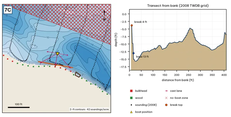
Orange line: break top. Blue dot: base of the break. Black dots: 2008 TWDB soundings. Shoreline squares: bank type (see the Bank-Type Map chapter). Contour interval: 2 ft, at 42 soundings per acre within 250 ft.
| Measure | Value |
|---|---|
| Depth at the bank | 3.8 ft (first wet grid cell, 8 ft from the OSM shoreline) analysis |
| Break top | 6.4 ft, 8 ft from the bank analysis |
| Base of the break | 14.8 ft, 25 ft from the bank analysis |
| Slope | steepest 5.3 ft per 10 ft; average 4.8 ft per 10 ft across the break analysis |
| Bank type | bulkhead (confidence: medium) |
| Deep-water access | 20-ft water 122 ft away; 25-ft water 742 ft away; deepest within 300 ft: 22 ft analysis |
| Data support | good (a 2008 sounding lies within 15 ft of the break) |
Why a giant would use it. The south bulkhead below the railroad bridge: from about 4 to 13 ft within 8 ft. Score factors: cover = bulkhead; forage = sunfish; pressure = downtown. inference
Wind and current. Best wind: from the N (blowing onto this bank) analysis. A north wind blows onto it. Moderate current. inference
Sun and shade today (Oct 12). This is the S bank of the reach. With 40-ft trees, a shade band of 25 ft or more falls on the water at: 1:00 pm, 2:00 pm, 3:00 pm, 4:00 pm, 5:00 pm, 6:00 pm, 6:30 pm. analysis
Boat position and cast lanes. Hold over about 16 ft, roughly 70 ft off the bank (yellow triangle). Fan three casts to the break top (magenta arrows), then turn and work parallel to the break along the dashed lane inference.
Big-bass plan by season (★ = this spot is a seasonal pick) inference
- Winter / pre-spawn: 3/4–1 oz football jig or 10-in Texas-rigged worm dragged down the face from 6 to 15 ft, then on into the 22-ft water. Long pauses.
- Spawn: Slow-sinking glide counted down to the break top (6 ft), swum along it and killed at the edge.
- Summer: Walking topwater or wake bait along the bank in the first and last hour; a 10–12 in worm on the 15-ft base in between.
- Fall: Swimbait or glide run parallel to the break top as shad push up.