Reach 4 · MoPac to Barton Creek (Zilker)
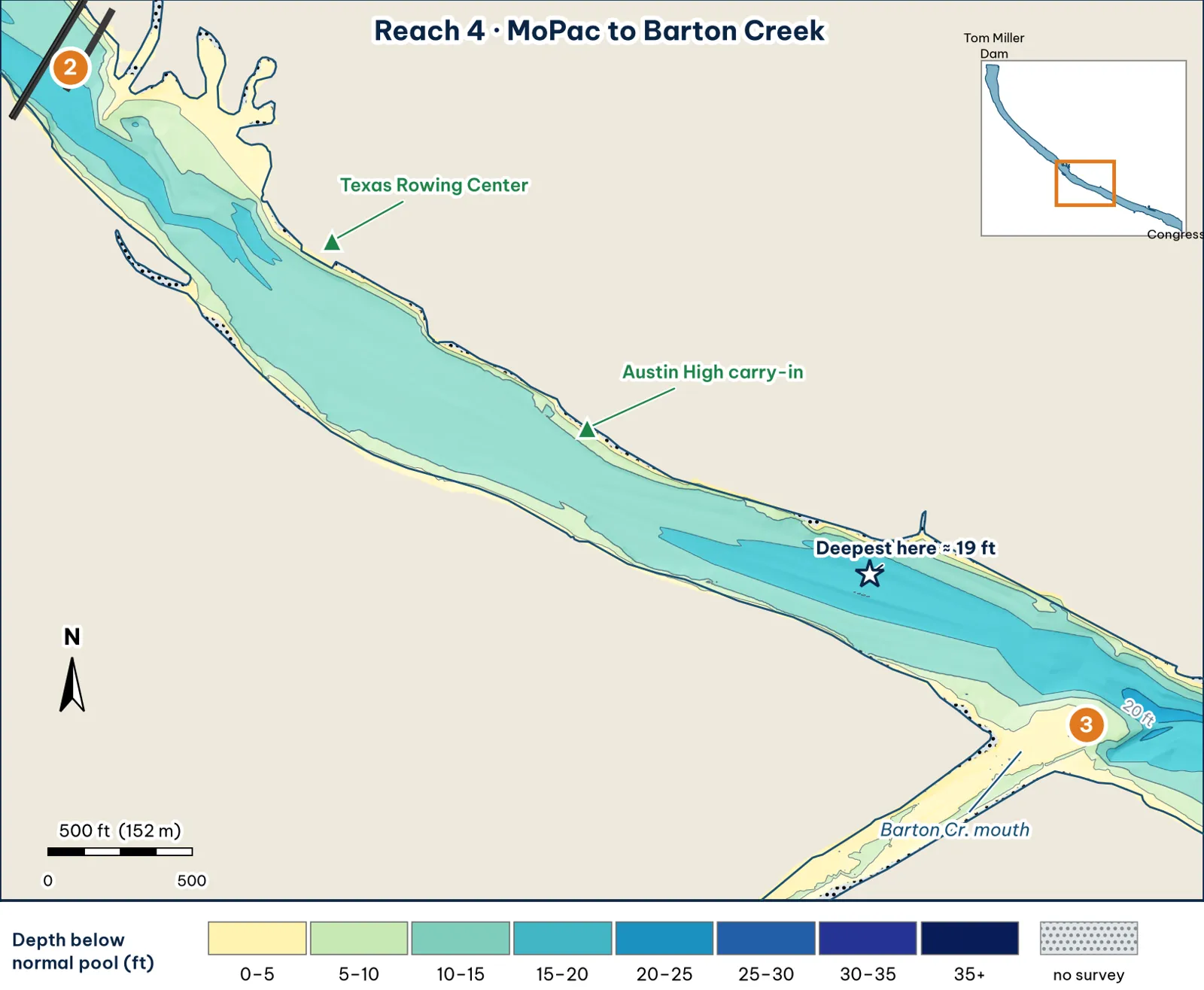
The Zilker stretch: a narrow, even-bottomed channel. The deepest water sits at its lower end, as the lake approaches Barton Creek.
The bottom
- The most even bottom in the guide analysis:
- It's about 390 ft wide (roughly 340–490 ft).
- The deepest point of each cross-section runs 13–19 ft, with a median of about 14 ft.
- The deepest line runs near the middle and drifts gently from side to side.
- Banks analysis:
- 10 ft comes about 35–40 ft off either bank.
- 15 ft shows up only in scattered deeper pockets, mostly toward the downstream end. The deepest cell, about 19 ft, is about 2.4 miles below the dam, just above Barton Creek.
- What the old contours show. TWDB's 2008 contour map shows this as a wide, flat basin, mostly 14–19 ft, with no 410 contour (19+ ft) (TWDB 2008).
Cover and grass
- Grass. This is the heart of the "between MoPac and I-35" grass buildup, which forced evening cruises to be cancelled (City of Austin, FY2024–25). Clear water lets fanwort grow "in relatively deep water" (City of Austin, FY2023).
- Docks. The Texas Rowing Center docks are on the north shore (TPWD paddling trail).
Water: clarity and current
- Clarity. Clear.
- Current. Release current spreads evenly across this uniform channel. There isn't much to break it up except bank points and any grass edges analysis.
Through the seasons
| Season | What to expect | Play analysis |
|---|---|---|
| Spring | Clear water and grass growing back. A spring 2026 guide report had fish on Texas-rigged stick worms in submerged grass (Captain Experiences) | Burn the grass tops |
| Summer | Surface mats (City). Schools chasing shad in open water (Captain Experiences) | Dawn. Cover water down the open lane between the mats |
| Fall | Grass tops below the surface | Long drifts along the grass edges. Wind-blown banks |
| Winter | Cold and even, with little to set one spot apart | Pass through to Reach 5's Barton water |
How to fish it for a giant
The Approach
- Where a giant sits. Breaks in the grass edge along the 5–10 ft band, and any wood. This reach has little deep water close to cover, so it scores lower for giants analysis.
- How. Cover water with a 6-in swimbait or a glide along the grass edge in low light, then slow down with a big worm where the edge bends inference.
- Line. Braid with a fluorocarbon leader when the grass is thick analysis.
Access, hazards and rules
- Austin High carry-in ramp. It's across Stephen F. Austin Dr. from the school. TPWD says it's "suitable only for canoes or small cartop boats." There's no fee, and parking is paid street parking (TPWD access; City of Austin).
- Zilker parking. It costs $3 an hour on weekends and holidays from spring break through Labor Day. In fall it's normally free (City of Austin).
Rule
Gas motors are banned. Electric motors are limited to 5 hp, and only from 5 am to 10 pm (City code 8-5-82).
Pro tip
On an even bottom like this, the grass edge is the structure. Idle down the reach watching your graph. Any spot where the grass line pokes out toward the channel or dents in toward the bank is worth a dozen casts analysis.
Reach 4 Spots: Austin High to Zilker
3 spots: 4A, 4B, 4C. Close-up maps from the 2008 survey; scores from the giant ranking.
4A · Texas Rowing Center north bank
#40 of 51Deep water2Cover3Forage3Low pressure2Data4Best: any season (not a seasonal pick)
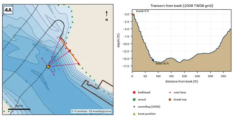
Orange line: break top. Blue dot: base of the break. Black dots: 2008 TWDB soundings. Shoreline squares: bank type (see the Bank-Type Map chapter). Contour interval: 2 ft, at 33 soundings per acre within 250 ft.
| Measure | Value |
|---|---|
| Depth at the bank | 0.2 ft (first wet grid cell, 2 ft from the OSM shoreline) analysis |
| Break top | 0.6 ft, 2 ft from the bank analysis |
| Base of the break | 15.2 ft, 78 ft from the bank analysis |
| Slope | steepest 2.5 ft per 10 ft; average 2.0 ft per 10 ft across the break analysis |
| Bank type | bulkhead (confidence: medium) |
| Deep-water access | 20-ft water 1944 ft away; 25-ft water 6757 ft away; deepest within 300 ft: 17 ft analysis |
| Data support | fair (nearest sounding 38 ft from the break) |
Why a giant would use it. The Texas Rowing Center north bank. A bulkhead and docks drop to about 15 ft within 80 ft. Docks give shade, and the bulkhead gives hard cover. Score factors: cover = docks, bulkhead; forage = sunfish under docks; pressure = rental docks, heavy traffic. inference
Wind and current. Best wind: from the SW (blowing onto this bank) analysis. A SW wind blows onto it. Moderate current. inference
Sun and shade today (Oct 12). This is the NE bank of the reach. With 40-ft trees, a shade band of 25 ft or more falls on the water at: 8:05 am. analysis
Boat position and cast lanes. Hold over about 16 ft, roughly 122 ft off the bank (yellow triangle). Fan three casts to the break top (magenta arrows), then turn and work parallel to the break along the dashed lane inference.
Big-bass plan by season (★ = this spot is a seasonal pick) inference
- Winter / pre-spawn: 3/4 oz jig crawled down the slope off the dock ends.
- Spawn: Soft glide skipped or 'chopped' beside the dock posts so it hangs near the cover.
- Summer: Skip a jig or a 7-in stick worm deep under the shade; the slope reaches 15 ft about 78 ft out.
- Fall: Swimbait along the outside edge of the dock line.
4B · South bank wood line, Zilker
#32 of 51Deep water2Cover3Forage3Low pressure3Data4Best: any season (not a seasonal pick)
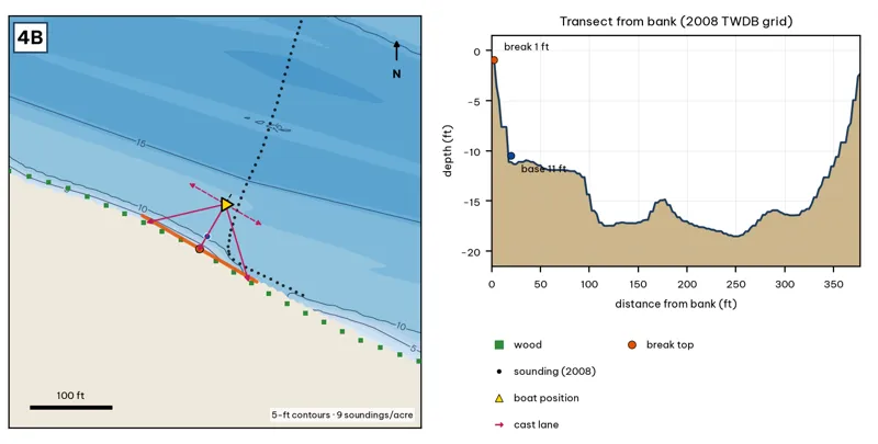
Orange line: break top. Blue dot: base of the break. Black dots: 2008 TWDB soundings. Shoreline squares: bank type (see the Bank-Type Map chapter). Contour interval: 5 ft, at 9 soundings per acre within 250 ft.
| Measure | Value |
|---|---|
| Depth at the bank | 0.9 ft (first wet grid cell, 0 ft from the OSM shoreline) analysis |
| Break top | 2.4 ft, 0 ft from the bank analysis |
| Base of the break | 10.0 ft, 20 ft from the bank analysis |
| Slope | steepest 4.6 ft per 10 ft; average 3.8 ft per 10 ft across the break analysis |
| Bank type | wood (confidence: low-medium) |
| Deep-water access | 20-ft water 1006 ft away; 25-ft water 4324 ft away; deepest within 300 ft: 19 ft analysis |
| Data support | fair (nearest sounding 36 ft from the break) |
Why a giant would use it. The wooded south bank at Zilker. It drops steeply from about 1 to 10 ft within 20 ft. Score factors: cover = wooded bank; forage = sunfish; pressure = moderate. inference
Wind and current. Best wind: from the NNE (blowing onto this bank) analysis. An NNE wind blows onto it. Under S winds it is in the lee. Moderate current. inference
Sun and shade today (Oct 12). This is the SW bank of the reach. With 40-ft trees, a shade band of 25 ft or more falls on the water at: 1:00 pm, 2:00 pm, 3:00 pm, 4:00 pm, 5:00 pm, 6:00 pm, 6:30 pm. analysis
Boat position and cast lanes. Hold over about 12 ft, roughly 65 ft off the bank (yellow triangle). Fan three casts to the break top (magenta arrows), then turn and work parallel to the break along the dashed lane inference.
Big-bass plan by season (★ = this spot is a seasonal pick) inference
- Winter / pre-spawn: 3/4–1 oz football jig or 10-in Texas-rigged worm dragged down the face from 2 to 10 ft, then on into the 19-ft water. Long pauses.
- Spawn: Slow-sinking glide counted down to the break top (2 ft), swum along it and killed at the edge.
- Summer: Walking topwater or wake bait along the bank in the first and last hour; a 10–12 in worm on the 10-ft base in between.
- Fall: Swimbait or glide run parallel to the break top as shad push up.
4C · North-bank drop into the 19-ft pocket
#24 of 51Deep water2Cover3Forage3Low pressure3Data5Best: any season (not a seasonal pick)
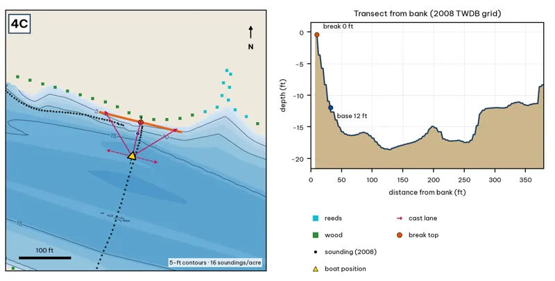
Orange line: break top. Blue dot: base of the break. Black dots: 2008 TWDB soundings. Shoreline squares: bank type (see the Bank-Type Map chapter). Contour interval: 5 ft, at 16 soundings per acre within 250 ft.
| Measure | Value |
|---|---|
| Depth at the bank | 0.4 ft (first wet grid cell, 8 ft from the OSM shoreline) analysis |
| Break top | 1.7 ft, 8 ft from the bank analysis |
| Base of the break | 14.2 ft, 42 ft from the bank analysis |
| Slope | steepest 5.1 ft per 10 ft; average 3.5 ft per 10 ft across the break analysis |
| Bank type | wood (confidence: low-medium) |
| Deep-water access | 20-ft water 1003 ft away; 25-ft water 4347 ft away; deepest within 300 ft: 19 ft analysis |
| Data support | good (a 2008 sounding lies within 15 ft of the break) |
Why a giant would use it. A north-bank drop into the 19-ft pocket just above Barton Creek: from about 0 to 12 ft within 32 ft. Score factors: cover = wooded bank drop; forage = sunfish; pressure = moderate. inference
Wind and current. Best wind: from the SSW (blowing onto this bank) analysis. A SSW wind blows onto it. This is the prevailing wind, so it is often windblown. Moderate current. inference
Sun and shade today (Oct 12). This is the NE bank of the reach. With 40-ft trees, a shade band of 25 ft or more falls on the water at: 8:05 am. analysis
Boat position and cast lanes. Hold over about 16 ft, roughly 88 ft off the bank (yellow triangle). Fan three casts to the break top (magenta arrows), then turn and work parallel to the break along the dashed lane inference.
Big-bass plan by season (★ = this spot is a seasonal pick) inference
- Winter / pre-spawn: 3/4–1 oz football jig or 10-in Texas-rigged worm dragged down the face from 2 to 14 ft. Long pauses.
- Spawn: Slow-sinking glide counted down to the break top (2 ft), swum along it and killed at the edge.
- Summer: Walking topwater or wake bait along the bank in the first and last hour; a 10–12 in worm on the 14-ft base in between.
- Fall: Swimbait or glide run parallel to the break top as shad push up.