Landing giants · 8 lb and up · v3 whole lake
Lady Bird Lake
Big Bass Guide
Tom Miller Dam to Longhorn Dam: 6.0 river miles in twelve reaches, every spot ranked for giant potential, mapped from the Texas Water Development Board's 2008 sonar survey.
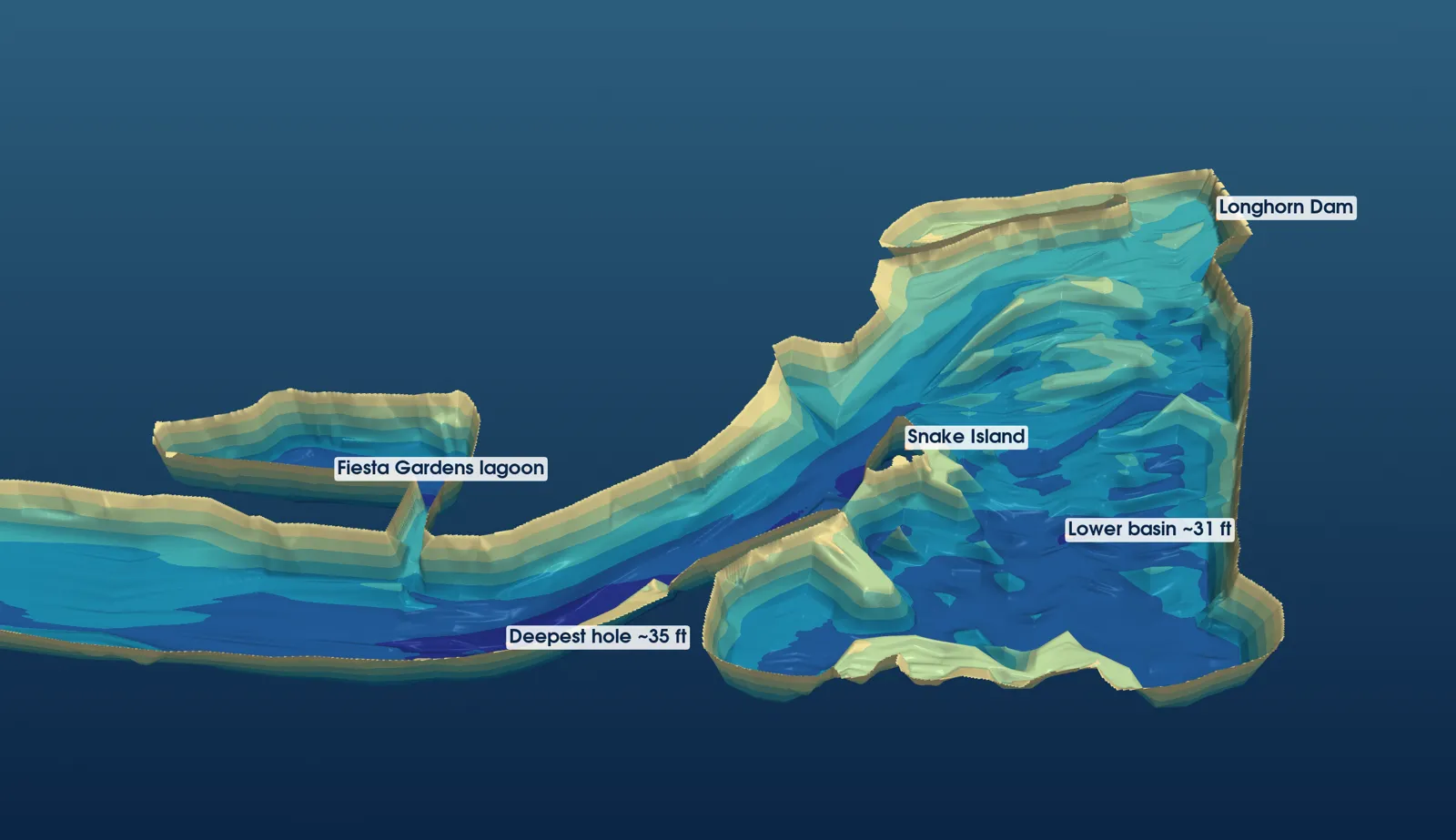
3-D view of the Holly bend and lower basin, the deepest water in the lake (about 35 ft), from TWDB 2008 survey points, depth exaggerated.
12reaches · 6.0 mi
51spots ranked
14.05 lblake record (2025)
69Lady Bird ShareLunkers
Explore
Interactive map51 spots on OpenStreetMapTop giant spotsScored and rankedSpot finderFilter by reach and seasonSeasonsWhere giants live, month by monthRecords & ShareLunkers14.05-lb lake record; 69 entriesLures & techniquesGlides, jigs, big worms, night, live baitTackle & landingLanding giants near pilingsFish careHandling and ShareLunker entry
Quick-reference card
| Top 5 spots | 1A tailrace (90) · 10C Harpers Branch hole (90) · 12A Snake Island tip (90) · 10A I-35 piers (87) · 11B Fiesta Gardens lagoon (83) |
| Giant months | Feb (14 entries) and Mar (12) of 69 Lady Bird ShareLunkers; 6 of 8 fish over 10 lb came Jan 22–Mar 30 |
| Lake record | 14.05 lb, 27.75 in, Willie Pipkin, Feb 5, 2025; bedding fish, Barton Creek shoreline, Texas-rigged Zoom Fluke |
| Deepest water | ~35 ft, Holly bend (11C) · 33 ft, Harpers Branch (10C) · 31 ft, Snake Island channel (12A) · 30 ft, tailrace (1A) and lagoon (11B) |
| Winter | Football jig / 10-in worm into the deep holes: 10C, 11C, 12A, 7A, 1A |
| Spawn | Soft jerkbait / stick worm, sight-fishing: 9E, 9A, 5B, 12B, 12C |
| Summer | Shade and piers, dawn and 7–10 pm: 10A, 8A, 8B, 6A, 3A |
| Fall | Glide / swimbait on creek deltas and island tips: 9A, 10C, 12A, 1E |
| Glide countdown | 4 in/s: 10 s ≈ 3.3 ft · 6 in/s: 10 s = 5 ft · 7 in/s: 10 s ≈ 5.8 ft |
| Line | 20–25 lb fluorocarbon at piers (zebra mussels); retie after contact |
| Rules | 14–21 in slot; 5 bass, 1 over 21 in · electric only, 5 hp, 5 am–10 pm · no game fish as bait; sunfish OK on this lake |
| ShareLunker | 8 lb or 24 in: enter in the app · 13 lb+ Jan 1–Mar 31: call (903) 681-0550, keep her in the water |
| Ramps | Holiday Inn (west of I-35, unimproved) · Festival Beach (one lane, ~5 trailers) |
Every line is sourced in the chapters above.
The twelve reaches
Reach 1Dam–Red BudReach 2Red Bud–MoPacReach 3MoPacReach 4ZilkerReach 5Barton mouthReach 6Lamar–RR bridgeReach 7Shoal–1st StReach 81st St–CongressReach 9Congress–BlunnReach 10Blunn–Festival (I-35)Reach 11Festival–HollyReach 12Lower basin–Longhorn Dam
Not a navigation chart
Depths are from TWDB's December 2008 survey, gridded by me analysis. TWDB says its maps are "not intended for use as recreational boating maps, fishing maps." Spot GPS is ±50–100 ft unverified.